
Monitoring method and system for farmland fire and straw burning based on multisource remote sensing data

A technology of remote sensing data and fire, which is applied in the field of remote sensing, can solve the problems of difficulty in meeting the requirements of precision effects, insufficient application, small time resolution of LandsatTM, etc., and achieve the effect of overcoming the limitations of effectiveness and precision

Active Publication Date: 2017-08-18
INST OF REMOTE SENSING & DIGITAL EARTH CHINESE ACADEMY OF SCI
View PDF2 Cites 17 Cited by
  • Summary
  • Abstract
  • Description
  • Claims
  • Application Information

AI Technical Summary

Problems solved by technology

The multi-spectral technical methods using MODIS, Landsat TM and other data are also mainly focused on the research of forest and grassland fires. If the related models and methods are transplanted to the underlying surface of farmland, they will be affected by water bodies, ravines, roads, etc., and the accuracy of extraction The effect is difficult to meet the requirements, and the relatively small time resolution of Landsat TM is also one of the main reasons for the insufficient application

Method used


Image

  • Monitoring method and system for farmland fire and straw burning based on multisource remote sensing data
  • Monitoring method and system for farmland fire and straw burning based on multisource remote sensing data
  • Monitoring method and system for farmland fire and straw burning based on multisource remote sensing data

Examples


Embodiment Construction

[0064] In order to make the purpose, technical solutions and advantages of the embodiments of the present invention clearer, the technical solutions in the embodiments of the present invention will be clearly and completely described below in conjunction with the drawings in the embodiments of the present invention. Obviously, the described embodiments It is a part of embodiments of the present invention, but not all embodiments. Based on the embodiments of the present invention, all other embodiments obtained by persons of ordinary skill in the art without creative efforts fall within the protection scope of the present invention.

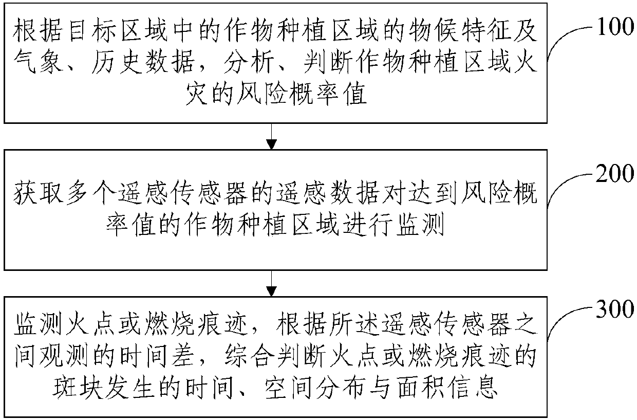
[0065] Embodiment 1 of the present invention discloses a specific implementation of a method for monitoring farmland fires and straw burning based on multi-source remote sensing data, see figure 1 , the monitoring method specifically includes the following content:

[0066] Step 100: According to the phenological characteristics, meteorological a...


PUM


Abstract

The invention provides a monitoring method and a system for farmland fire and straw burning based on multisource remote sensing data. The method comprises steps: according to phenological characteristics and meteorological and historical data of a crop growing area in a target area, a fire risk possibility value of the crop growing area is analyzed and judged; remote sensing data of multiple remote sensors are acquired to monitor a crop growing area which achieves the risk possibility value; a fire point or a burning mark is monitored, and according to an observation time difference between the remote sensors, the fire point or burning mark spot happening time, spatial distribution and area information are judged comprehensively. Accurate and reliable monitoring can be carried out on farmland fire and straw burning, the monitoring result acquisition efficiency is high, the monitored result precision is high, limitations of effectiveness and precision by a single remote sensor and a single monitoring method can be overcome at the same time, a more accurate data support is provided for controlling the farmland fire and straw burning, and a support is further provided for accurate fire monitoring.

Description

technical field [0001] The invention relates to the technical field of remote sensing, in particular to a method and system for monitoring farmland fire and straw burning based on multi-source remote sensing data. Background technique [0002] The annual summer and autumn harvest seasons are often the seasons of high incidence of farmland fires and straw burning. Farmland fires are often caused by dry climate or man-made accidents, resulting in a large amount of food, population and property losses; straw burning in farmland fires is one of the causes of seasonal serious air pollution. In addition to causing soil compaction and biodiversity decline and other damage to the soil environment, straw burning will also cause serious problems in transportation, civil aviation, insurance claims, and food management. Therefore, it is urgent to carry out effective supervision on farmland fire and straw burning. [0003] At present, the main method of farmland fire and straw burning ...

Claims


Application Information

Patent Timeline
Patent Type & Authority Applications(China)
IPC IPC(8): G06Q50/02G06Q50/26G06K9/00
CPCG06Q50/02G06Q50/265G06V20/188
Inventor 王树东宋雨伦杨邦会吴太夏王楠占玉林黄长平郑姚敏翟涌光
Owner INST OF REMOTE SENSING & DIGITAL EARTH CHINESE ACADEMY OF SCI
Learn More