Laser scanning measurement device

A technology of laser scanning and measuring device, applied in the field of surveying and mapping, can solve the problem of inability to obtain building specification data and so on

Inactive Publication Date: 2017-09-01
SHANGHAI HUACE NAVIGATION TECH
View PDF5 Cites 27 Cited by
  • Summary
  • Abstract
  • Description
  • Claims
  • Application Information

AI Technical Summary

Problems solved by technology

[0003] But at present, the street view map can only be viewed, and the specification data (length, width and height) of the building cannot be obtained based on the street view map data.

Method used


Image

  • Laser scanning measurement device

Examples


Embodiment Construction

[0025] In the following description, numerous specific details are given in order to provide a more thorough understanding of the present invention. It will be apparent, however, to one skilled in the art that the present invention may be practiced without one or more of these details. In other examples, some technical features known in the art are not described in order to avoid confusion with the present invention.

[0026] In order to thoroughly understand the present invention, detailed steps and detailed structures will be provided in the following description, so as to illustrate the technical solution of the present invention. Preferred embodiments of the present invention are described in detail below, however, the present invention may have other embodiments besides these detailed descriptions.

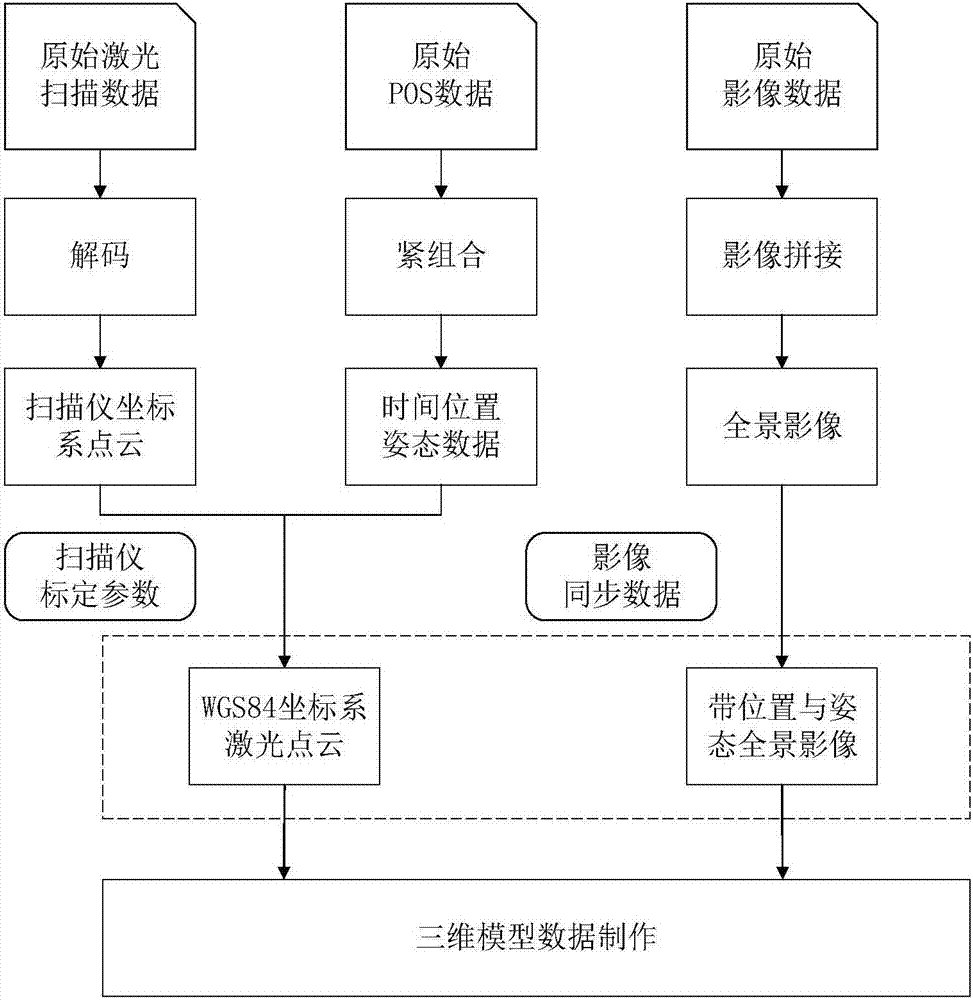
[0027] The invention provides a laser scanning measuring device, comprising:

[0028] 3D laser scanner, used for laser scanning measurement and output coordinate system poi...


PUM


Abstract

The invention provides a laser scanning measurement device. The laser scanning measurement device comprises a three-dimensional laser scanner used for carrying out laser scanning measurement and outputting coordinate system point cloud data, a GNSS / IMU combined positioning attitude determination system used for carrying out calculation according to GNSS data and IMU data to acquire time position attitude data, a panorama camera used for acquiring panorama image data containing position and attitude data, a point cloud data processing system used for calibrating scanner parameters according to the coordinate system point cloud data and the time position attitude data to generate WGS84 coordinate system laser point cloud, and a three-dimensional model modeling system used for carrying out three-dimensional model data establishment according to the coordinate system laser point cloud and the panorama image data. The laser scanning measurement device is advantaged in that the laser scanning measurement device can be widely applied to the three-dimensional digital city, general urban management part survey, highway reorganization and expansion, traffic infrastructure measurement, mine three-dimensional measurement, navigation channel embankment measurement and island reef shoreline three-dimensional measurement fields.

Description

technical field [0001] The invention relates to the field of surveying and mapping, in particular to a laser scanning measuring device. Background technique [0002] Street View is a reality map service. Provide users with 360-degree panoramic images of cities, streets or other environments, and users can obtain an immersive map browsing experience through this service. Through Street View, you can truly see high-definition scenes on the street as long as you sit in front of the computer. It is a good tool for traveling and driving, just like the GPS in people's hearts. [0003] But at present, the street view map can only be viewed, and the specification data (length, width and height) of the building cannot be obtained according to the street view map data. Contents of the invention [0004] The invention provides a laser scanning measuring device, comprising: [0005] 3D laser scanner, used for laser scanning measurement and output coordinate system point cloud data...

Claims


Application Information

Patent Timeline
Patent Type & Authority Applications(China)
IPC IPC(8): G01B11/00G01S19/45G01S19/47G01C21/16G01C21/00G01C11/00G06T17/05
CPCG01B11/002G01C11/00G01C21/005G01C21/165G01S19/45G01S19/47G06T17/05
Inventor 何伟姜春生毛勋晔杨洋魏立龙
Owner SHANGHAI HUACE NAVIGATION TECH
Why Eureka
Try Eureka