A method and system for monitoring soil wind erosion based on remote sensing data
A technology of remote sensing data and soil, applied in the field of remote sensing, can solve the problems of lack of data support, can only assess soil wind erosion at a specific time and in a specific area, and it is difficult to assess wind erosion, so as to improve the accuracy. Effect
Active Publication Date: 2019-10-01
INST OF REMOTE SENSING & DIGITAL EARTH CHINESE ACADEMY OF SCI
View PDF5 Cites 0 Cited by
- Summary
- Abstract
- Description
- Claims
- Application Information
AI Technical Summary
Problems solved by technology
However, most of the relevant models and methods in the prior art come from the meteorological data of ground stations and auxiliary data of field samples (such as vegetation coverage, etc.), and lack dynamic data such as land use, soil texture, and soil moisture in different spatial distributions. Supported by data, the assessment of soil wind erosion can only be carried out at a specific time and in a specific area
Therefore, it is difficult to assess wind erosion in time and space dynamics, which further affects the monitoring results of soil wind erosion to a certain extent.
Method used
View moreImage
Smart ImageViewing Examples
Examples
Embodiment Construction
Login to View More PUM
 Abstract
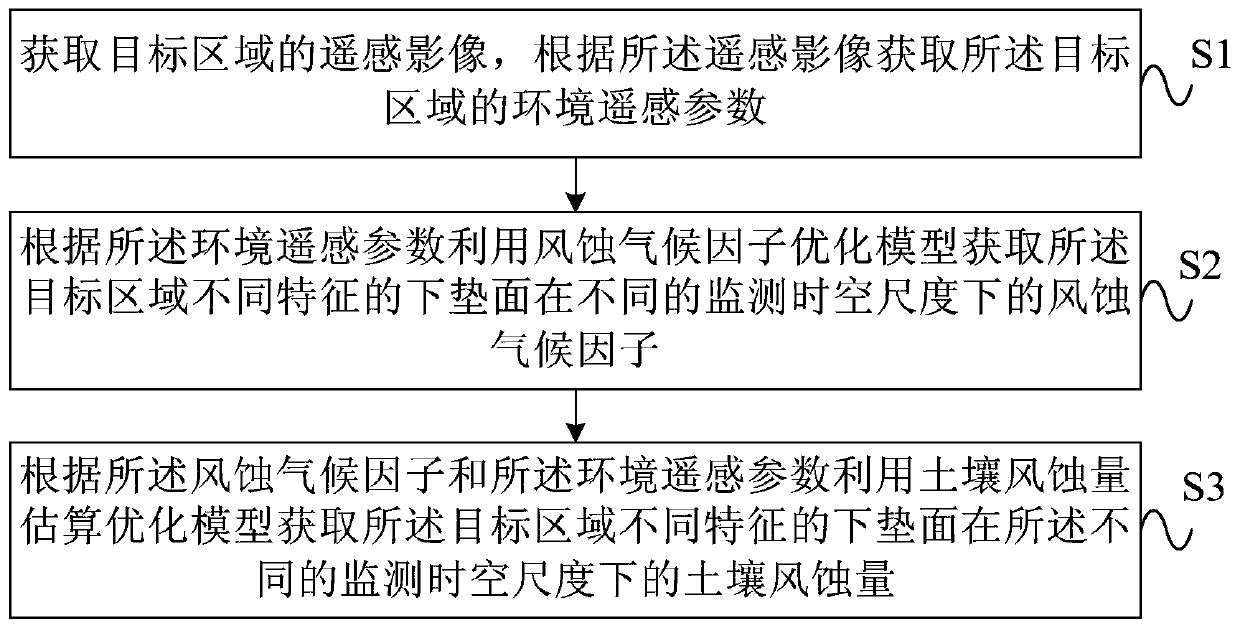
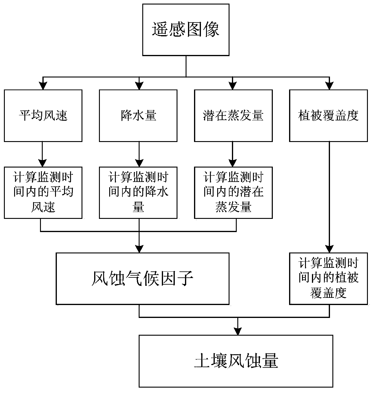
An embodiment of the present invention provides a soil wind erosion monitoring method and system based on remote sensing data. The method includes: acquiring remote sensing images of the target area, and acquiring environmental remote sensing parameters of the target area according to the remote sensing images; The factor optimization model obtains the wind erosion climate factors of the underlying surface with different characteristics in the target area at different monitoring time and space scales; according to the wind erosion climate factors and environmental remote sensing parameters, the soil wind erosion estimation optimization model is used to obtain the target area under different monitoring time and space scales The amount of soil wind erosion; the system is used to implement the above method. The embodiments of the present invention use environmental remote sensing parameters to obtain the soil wind erosion in different time and space distributions in the target area according to the wind erosion climate factor optimization model and the soil wind erosion estimation optimization model. Realize the monitoring of soil wind erosion at any time and space in the target area, realize the dynamic evaluation of soil wind erosion in time and space, and improve the objectivity and accuracy of soil wind erosion evaluation.
Description
technical field The embodiments of the present invention relate to the technical field of remote sensing, and in particular to a method and system for monitoring soil wind erosion based on remote sensing data. Background technique Wind erosion refers to the process of wind erosion, transportation and accumulation of soil and its loose parent material, referred to as wind erosion. It blows off the fine soil and nutrients in the soil cultivation layer, exposes the core soil and even the rocks, and reduces land productivity; it exposes the seeds during the planting season, or causes mechanical damage to the seedlings; the dust and sand produced enter the atmosphere and cause environmental pollution. pollute. Wind erosion, especially in arid and semi-arid regions, can lead to soil nutrient loss, sandstorms, vegetation destruction, and even large-scale desertification, seriously threatening regional sustainable development. Therefore, wind erosion monitoring of soil is a necess...
Claims
Login to View More Application Information
Patent Timeline
 Patent Type & Authority Patents(China)
IPC IPC(8): G06K9/00
CPCG06V20/13
Inventor 王树东丁建丽刘素红吴太夏王玉娟占玉林陈云坪王楠宋雨伦翟涌光
Owner INST OF REMOTE SENSING & DIGITAL EARTH CHINESE ACADEMY OF SCI
Features
- R&D
- Intellectual Property
- Life Sciences
- Materials
- Tech Scout
- Unparalleled Data Quality
- Higher Quality Content
- 60% Fewer Hallucinations
Learn More Browse by: Latest US Patents, China's latest patents, Technical Efficacy Thesaurus, Application Domain, Technology Topic, Popular Technical Reports.
© 2025 PatSnap. All rights reserved.Legal|Privacy policy|Modern Slavery Act Transparency Statement|Sitemap|About US| Contact US: help@patsnap.com


