MEMS (micro-electromechanical system) pressure sensor-based collaborative satellite positioning method and system

A pressure sensor and satellite positioning technology, applied in the field of satellite navigation, to achieve the effects of low energy consumption, convenience for civilian use and low cost

Inactive Publication Date: 2017-09-15
姜军毅
View PDF3 Cites 5 Cited by
  • Summary
  • Abstract
  • Description
  • Claims
  • Application Information

AI Technical Summary

Problems solved by technology

The MEMS pressure sensor can calculate the elevation dimension information with a certain precision, which can provide users with accur

Method used


Image

  • MEMS (micro-electromechanical system) pressure sensor-based collaborative satellite positioning method and system
  • MEMS (micro-electromechanical system) pressure sensor-based collaborative satellite positioning method and system
  • MEMS (micro-electromechanical system) pressure sensor-based collaborative satellite positioning method and system

Examples


Embodiment Construction

[0049] The following will clearly and completely describe the technical solutions in the embodiments of the present invention with reference to the accompanying drawings in the embodiments of the present invention. Obviously, the described embodiments are only some, not all, embodiments of the present invention. Based on the embodiments of the present invention, all other embodiments obtained by persons of ordinary skill in the art without making creative efforts belong to the protection scope of the present invention.

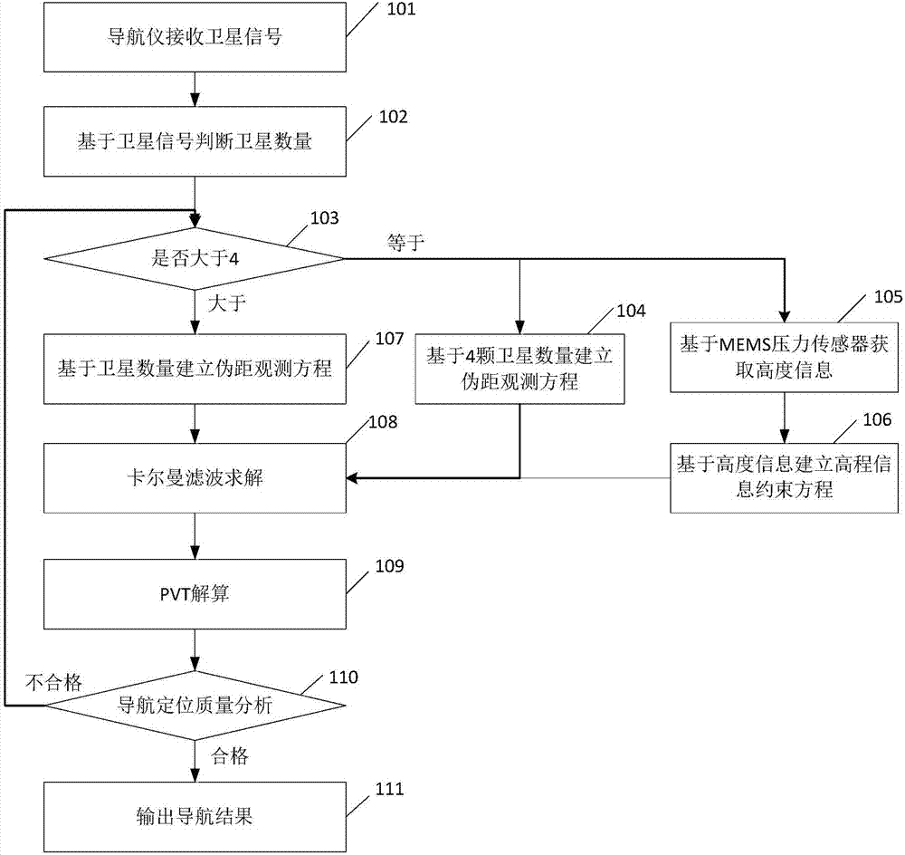
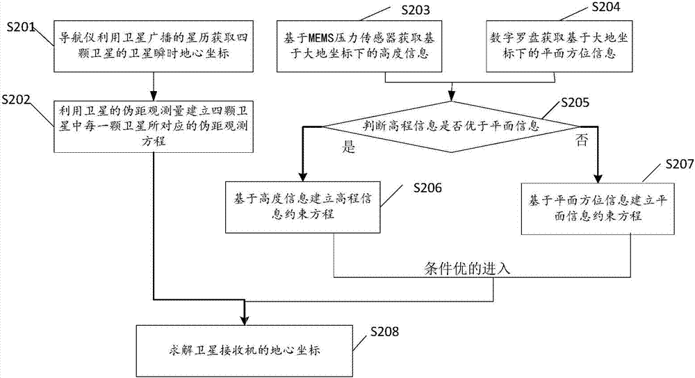
[0050] The method for coordinating satellite positioning based on MEMS pressure sensors involved in the present invention is mainly realized as follows: the navigator utilizes the ephemeris broadcast by satellites to obtain the instantaneous earth-centered coordinates of four satellites, based on the conversion relationship between the earth-centered coordinates and the geodetic coordinates, with The geodetic coordinates of the navigator is the solution target,...


PUM


Abstract

The invention discloses an MEMS (micro-electromechanical system) pressure sensor-based collaborative satellite positioning method and system. The method comprises the following steps that: a navigator obtains the satellite instantaneous geocentric coordinates of four satellites through using ephemeris broadcasted by the satellites, and the navigator, based on the conversion relationship of geocentric coordinates and geodetic coordinates, builds a pseudorange observation equation corresponding to each of the four satellites through using the pseudorange observation quantities of the satellites with the geodetic coordinate system of the navigator adopted as a solving objective; geodetic coordinate-based height information is obtained based on an MEMS pressure sensor, and an elevation information constraint equation is established based on the height information; and the current geodetic coordinate solving model of the navigator is formed based on the pseudorange observation equation and the elevation information constraint equation, and the geocentric coordinates of the navigator are obtained based on the conversion relationship of the geocentric coordinates and the geodetic coordinates. According to the MEMS (micro-electromechanical system) pressure sensor-based collaborative satellite positioning method and system provided by the embodiments of the invention, the MEMS pressure sensor and the satellite signals are combined to perform positioning, and therefore, a collaborative positioning function is realized under a condition that satellite signal difference or only four satellites exist.

Description

technical field [0001] The invention relates to the technical field of satellite navigation, in particular to a method and system for coordinating satellite positioning based on MEMS pressure sensors. Background technique [0002] The existing satellite positioning system receives satellite signals through a navigator, first uses the ephemeris broadcast by satellites to calculate the exact position coordinates of each satellite, and then uses the pseudo-range observations of the satellites to establish ρ to establish the pseudo-range observation equation (1), Because there is a clock error in the receiver, it is necessary to take the receiver clock error as an unknown and solve it together with the receiver position coordinates (X, Y, Z) on the navigator. [0003] [0004] Among them, (X i , Y i ,Z i ) is the instantaneous geocentric coordinates of the satellite obtained from the satellite ephemeris, (X, Y, Z) is the geocentric coordinates of the receiver to be obtaine...

Claims


Application Information

Patent Timeline
IPC IPC(8): G01S19/47G01C21/16
CPCG01C21/165G01S19/47
Inventor 夏敬廷李倩霞花城易家莉李彩霞
Owner 姜军毅
Why Eureka
Try Eureka