Urban GNSS navigation quality evaluation and predication method and system

A quality assessment and urban technology, applied in the field of satellite navigation, can solve the problems of occlusion information considering the multipath effect of the environment, and the trajectory environment cannot be predicted, so as to achieve the effect of suppressing the multipath effect

Active Publication Date: 2017-09-22
深圳中铭高科信息产业股份有限公司
View PDF6 Cites 19 Cited by
  • Summary
  • Abstract
  • Description
  • Claims
  • Application Information

AI Technical Summary

Problems solved by technology

The system only calculates the occlusion angle through the angle of the building, not the real-time position of the satellite, and does not use the occlusion information to consider

Method used


Image

  • Urban GNSS navigation quality evaluation and predication method and system
  • Urban GNSS navigation quality evaluation and predication method and system
  • Urban GNSS navigation quality evaluation and predication method and system

Examples


Embodiment Construction

[0044] The following will clearly and completely describe the technical solutions in the embodiments of the present invention with reference to the accompanying drawings in the embodiments of the present invention. Obviously, the described embodiments are only some, not all, embodiments of the present invention. Based on the embodiments of the present invention, all other embodiments obtained by persons of ordinary skill in the art without making creative efforts belong to the protection scope of the present invention.

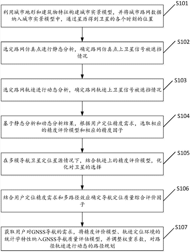
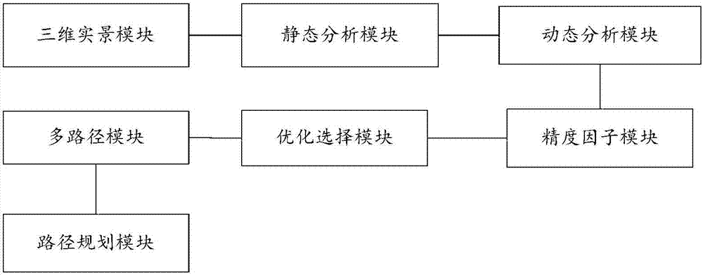
[0045] The method for assessing and predicting the quality of urban GNSS navigation involved in the present invention comprises the following steps: constructing a city real-scene model by using urban topography and building features, and incorporating urban road network data into the city real-scene model, and obtaining each of the satellites through the ephemeris. position at any time; select the road network simulation point for static analysis to determine ...


PUM


Abstract

The invention discloses an urban GNSS navigation quality evaluation and predication method and system. The method comprises the following steps: obtaining position of a satellite at each moment through ephemeris; selecting a road network simulation point to carry out static analysis, and determining satellite signal shield situations on the road network simulation point; selecting a road network path for dynamic analysis, and determining satellite signal shield situations on the road network path; selecting a corresponding precision evaluation model and a corresponding precision factor; under the condition of a multi-mode navigation satellite positioning satellite source, through the precision evaluation model on the path, optimizing selection of satellites; with user positioning accuracy requirements and multipath effect being combined, determining navigation positioning quality comprehensive evaluation factors; and carrying out dynamic path planning on the path trajectory. According to the urban GNSS navigation quality evaluation and predication method and system, through high-precision basic 3D model simulation, a high-precision space satellite orbit, a ground segment multi-path effect model, a navigation positioning quality evaluation model and a sequence quality prediction mechanism are established.

Description

technical field [0001] The invention relates to the technical field of satellite navigation, in particular to a method and system for assessing and predicting the quality of urban GNSS navigation. Background technique [0002] Global Navigation Satellite System (Beidou System, GPS, GLONASS, GALILE) has formed a powerful application of global space positioning. Blind areas hinder the comprehensive application of satellite navigation and positioning. Therefore, it is necessary to conduct a detailed investigation of the positioning environment of modern cities, provide a basis for the design and analysis of urban navigation and positioning enhancements, strengthen the construction of the basic space-time environment for location services, and provide a basis for enhanced positioning. Supporting platform and technical framework. [0003] In recent years, major map manufacturers have begun to draw accurate 3D maps of various cities. The 3D map can accurately describe the enviro...

Claims


Application Information

Patent Timeline
IPC IPC(8): G01S19/08
CPCG01S19/08
Inventor 李倩霞夏敬廷花城易家莉李彩霞李欢乐
Owner 深圳中铭高科信息产业股份有限公司
Why Eureka
Try Eureka