Drone's low-altitude remote-sensing image high-resolution landform classifying method based on characteristic fusion

A technology of low-altitude remote sensing and feature fusion, which is applied to computer components, instruments, calculations, etc. It can solve the problems of low-altitude remote sensing images of unmanned aerial vehicles with unobvious features, large clutter interference, and inability to describe objects or objects.

Active Publication Date: 2017-10-24
CHONGQING UNIV
View PDF4 Cites 43 Cited by
  • Summary
  • Abstract
  • Description
  • Claims
  • Application Information

AI Technical Summary

Problems solved by technology

Its disadvantage is that it cannot describe the local distribution of colors in the image and the spatial position of each color, that is, it cannot describe a specific object or object in the image.
The SVM algorithm seeks the optimal classification surface between data based on statistics, and linearizes the nonlinear data by mapping it to the kernel function space, thereby simplifying the computational complexity and having a better classification effect; but how to choose Subspace and establishing a suitable model become the difficulty in the application of SVM
[0022] It can be seen from the introduction o

Method used


Image

  • Drone's low-altitude remote-sensing image high-resolution landform classifying method based on characteristic fusion
  • Drone's low-altitude remote-sensing image high-resolution landform classifying method based on characteristic fusion
  • Drone's low-altitude remote-sensing image high-resolution landform classifying method based on characteristic fusion

Examples


Embodiment Construction

[0080] The present invention will be described in further detail below in conjunction with the accompanying drawings of the description.

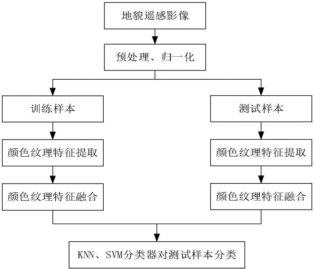
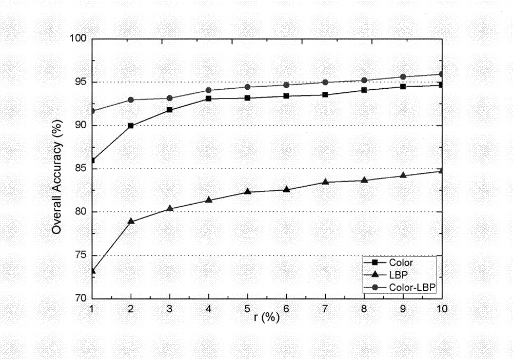
[0081]In order to effectively and quickly classify and identify the types of architectural landforms in a certain area, the present invention proposes a method for the classification of UAV high-resolution remote sensing image landforms based on the fusion of color and texture features. A landform classification model for computer-based high-resolution remote sensing images was obtained, and a map of the accuracy of landform classification was obtained.

[0082] The present invention is described in detail below in conjunction with accompanying drawing, specifically can be combined figure 1 .

[0083] 1) Import the images collected by drone aerial photography into the computer, and do basic image preprocessing such as filtering, so as to eliminate the interference of light, noise and other factors in the actual aerial photography environme...


PUM


Abstract

The invention discloses a drone's low-altitude remote-sensing image high-resolution landform classifying method based on characteristic fusion. The method comprises the following steps: selecting common and representative landforms from to-be-processed remote sensing images and using them as the training samples of the landforms; extracting the color characteristics and the texture characteristics from the training samples of each landform; fusing the color characteristics and the texture characteristics; using a classifying method to classify and learn the fused characteristics to obtain the classifying model for each landform; extracting and fusing the color characteristics and the texture characteristics of the low-altitude remote sensing images of the to-be-classified drones; and finally, based on the fused characteristics of the classifying objects and in combination with the classifying model of each obtained landform, using the classifiers to divide the classifying objects into a certain landform. Therefore, the classification of the drone's low-altitude remote sensing images is achieved. According to the method of the invention, it is possible to more effectively and more quickly to extract the verification characteristics so that the classification result becomes more accurate.

Description

technical field [0001] The invention relates to landform classification, specifically a method for high-resolution landform classification of low-altitude remote sensing images of drones based on fusion of color and texture features, and belongs to the technical field of landform classification of drone remote sensing images. Background technique [0002] UAV remote sensing is one of the development trends in the field of remote sensing. The UAV remote sensing system has the advantages of low operating cost and high task flexibility, and is an important tool for remote sensing data acquisition. With the maturity of technology and the needs of the civilian field, drones have gradually penetrated into various industries in the civilian field. In recent years, UAVs with different performances have been widely used in military battlefield reconnaissance and surveillance tasks and civilian research. According to the purpose, it can be divided into civil communication relay drone...

Claims


Application Information

Patent Timeline
IPC IPC(8): G06K9/62
CPCG06F18/2411G06F18/253
Inventor 黄鸿段宇乐陈美利刘嘉敏张丽梅
Owner CHONGQING UNIV
Why Eureka
Try Eureka