Mobile robot real-time positioning method based on laser radar and map matching

A mobile robot and laser radar technology, applied in two-dimensional position/channel control, instruments, surveying and navigation, etc., can solve the problem that the robot cannot perceive the position, and achieve the effect of improving time and space efficiency and wide applicability

Active Publication Date: 2017-11-24
SOUTH CHINA UNIV OF TECH
View PDF8 Cites 45 Cited by
  • Summary
  • Abstract
  • Description
  • Claims
  • Application Information

AI Technical Summary

Problems solved by technology

And the traditional mobile robot, even if it is given a map of the environment it reads in, the robot cannot perceive its own position before controlling its movement. The system can track the position of the robot using the Monte Carlo method

Method used


Image

  • Mobile robot real-time positioning method based on laser radar and map matching
  • Mobile robot real-time positioning method based on laser radar and map matching
  • Mobile robot real-time positioning method based on laser radar and map matching

Examples


Embodiment Construction

[0050] The present invention will be further described below in conjunction with specific examples.

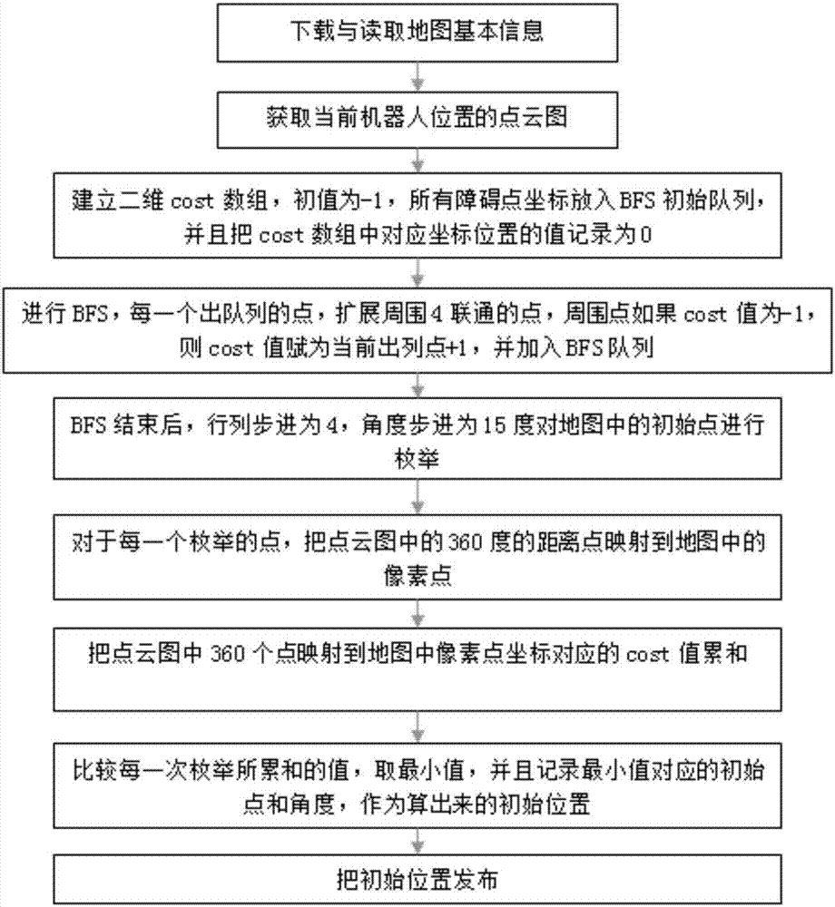
[0051] Such as figure 1 As shown, the real-time positioning method of a mobile robot based on lidar and map matching provided in this embodiment includes the following steps:

[0052] 1) Establish a 2D map: use the SLAM algorithm to establish a 2D obstacle map of the environment according to the principle of lidar ranging when the robot is moving in the environment. In the map, valid areas are divided into two categories, namely obstacle pixels and free pixels. Among them, the obstacle pixel indicates that there is an obstacle in the real space corresponding to this pixel, and the robot cannot reach or cross it, while the free pixel indicates that there is no obstacle in the space, and the robot can pass through.

[0053] 2) Divide the 2D map into blocks: Divide the map horizontally and vertically at equal distances, so that the map is divided into square blocks similar to a...


PUM


Abstract

The invention discloses a mobile robot real-time positioning method based on laser radar and map matching. The method comprises the steps that a 2D map of the environment is established; transverse and longitudinal checkerboard average blocking is performed on the 2D map according to the fixed interval distance; assumption deduction is performed on each block of the map, assuming that the upper left position of the block is the initial position of the robot, direction enumeration is performed on the basis of each block; as for each assumption, the point cloud data of laser radar are mapped to the map pixels; a matching degree model is established to judge the score of each assumption, and the sum of the pixel distance "obstacle pixel" Manhattan distance corresponding to all the point cloud data of the laser radar is accumulated as for each assumption; the block and the direction of the minimum sum are selected to act as the initial position and the direction of the robot; and the real-time position of the robot is tracked by using the Monte Carlo method in the movement of the robot. The robot is enabled to perceive its position only through the built-in laser sensor and the known map without assistance of artificial intervention or environmental markers.

Description

technical field [0001] The invention relates to the technical field of mobile robot positioning, in particular to a real-time positioning method for a mobile robot based on laser radar and map matching. Background technique [0002] With the high development of science and technology, the application fields of robot system are more and more extensive, such as industry, agriculture, medical treatment and so on. With the widespread application of robotic systems, intelligence has become an important direction of its development. As one of the important types of service robots, mobile robots, one of the directions of intelligence is navigation and obstacle avoidance during the movement process. An important link in the movement process of a mobile robot controlled by a computer is that the computer needs to know where the robot is, that is, the problem of robot positioning. [0003] In recent years, the field of sensors has emerged with a variety of products suitable for the ...

Claims


Application Information

Patent Timeline
Patent Type & Authority Applications(China)
IPC IPC(8): G05D1/02G01C21/20G01S17/93G01S17/48
Inventor 毕盛冯里千董敏
Owner SOUTH CHINA UNIV OF TECH
Why Eureka
Try Eureka