
Large-angle oblique imaging aerocamera targeted target positioning method

An aerial camera and target positioning technology, which is applied in surveying, mapping and navigation, measuring devices, instruments, etc., can solve problems affecting target positioning, volume application, and small laser ranging devices cannot meet the distance requirements.

Inactive Publication Date: 2017-12-19
CHANGCHUN INST OF OPTICS FINE MECHANICS & PHYSICS CHINESE ACAD OF SCI
View PDF3 Cites 15 Cited by
  • Summary
  • Abstract
  • Description
  • Claims
  • Application Information

AI Technical Summary

Problems solved by technology

At present, most target positioning algorithms are based on distance measurement, and the distance value of the target relative to the airborne optoelectronic equipment needs to be given by the target ranging equipment. The positioning accuracy is better than 15m and 20m respectively; however, when the aerial camera is flying at an altitude of 18,000m and obliquely imaging a target 50km away, the small laser ranging device cannot meet the distance requirements, and the large laser ranging is limited by its size and cannot be used in the aviation field. At the same time, long-distance laser ranging will also be affected by various factors such as the atmosphere, resulting in a decrease in ranging accuracy, thereby affecting the positioning of the target

Method used


Image

  • Large-angle oblique imaging aerocamera targeted target positioning method
  • Large-angle oblique imaging aerocamera targeted target positioning method
  • Large-angle oblique imaging aerocamera targeted target positioning method

Examples


Embodiment Construction

[0030] The present invention will be described in detail below with reference to the accompanying drawings and examples.

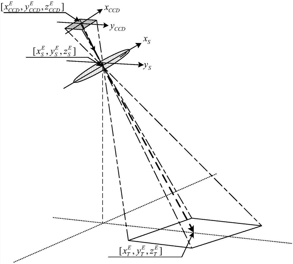
[0031] Target positioning is to obtain the geographical location information of the target area in the captured image, so as to effectively evaluate and analyze the target area. The airborne POS system is composed of GPS (Global Positioning System) and IMU (Inertial Measurement Unit). It integrates the advantages of GPS and IMU, greatly improves the performance and reliability, and can accurately measure the position and attitude of the aircraft. information.

[0032] use Represents the transformation matrix from the A coordinate system to the B coordinate system.

[0033]

[0034] Among them, [x A the y A z A ] T and [x B the y B z B ] T are the coordinates of the same point in the A coordinate system and the B coordinate system.

[0035] Four basic coordinate systems are needed in the target positioning process, the earth coordinate sy...


PUM


Abstract

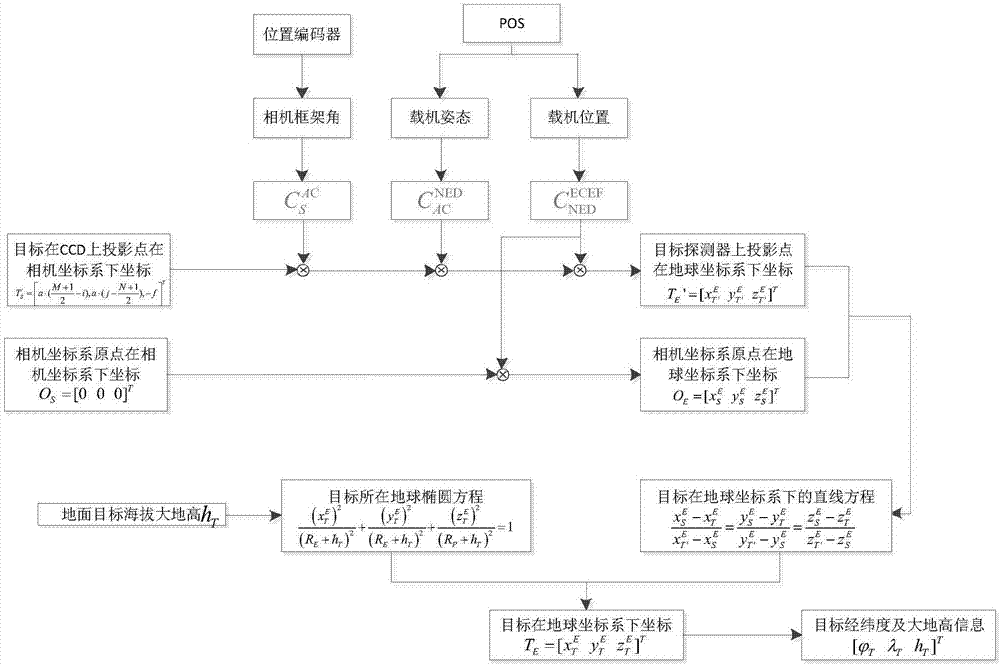
The invention discloses a large-angle oblique imaging aero-camera targeted target positioning method. In accordance with the problems that the shooting distance of a large-angle oblique imaging aero-camera is long, and the operating distance of laser distance measuring equipment is limited, and the invention provides a direct targeted target positioning algorithm which is independent of the distance measuring equipment. According to the position and the attitude information of a carrying aerial vehicle, measured by the carrying aerial vehicle POS ( position and orientation system) and frame angular position information measured by a position encoder in the aero-camera; a homogeneous coordinate conversion method is used for solving the direction of a target under a geodetic coordinate system; and an earth ellipsoid model and a digital elevation model are used for determining latitude and longitude information of the target point. According to the large-angle oblique imaging aero-camera targeted target positioning method disclosed by the invention, flight test data is used for verifying the validity of the target positioning algorithm; and when the flight height is 18000m, and the rolling angle of a shooting frame is smaller than 63 degrees, the target positioning circular probable error is smaller than 70m, so that engineering actual requirements can be met.

Description

technical field [0001] The invention belongs to the technical field of aerial imaging and measurement and control, and in particular relates to a ground target positioning method for a large-angle oblique imaging aerial camera. Background technique [0002] In addition to high-resolution imaging, the aerial camera also needs to perform high-precision positioning of the target at the same time. At present, most target positioning algorithms are based on distance measurement, and the distance value of the target relative to the airborne optoelectronic equipment needs to be given by the target ranging equipment. The positioning accuracy is better than 15m and 20m respectively; however, when the aerial camera is flying at an altitude of 18,000m and obliquely imaging a target 50km away, the small laser ranging device cannot meet the distance requirements, and the large laser ranging is limited by its size and cannot be used in the aviation field. , At the same time, long-distanc...

Claims


Application Information

Patent Timeline
Patent Type & Authority Applications(China)
IPC IPC(8): G01C11/00
CPCG01C11/00
Inventor 刘志明李清军丁亚林刘禹乔川
Owner CHANGCHUN INST OF OPTICS FINE MECHANICS & PHYSICS CHINESE ACAD OF SCI
Learn More