Remote sensing image missing data restoration method based on multi-image local interpolation

A technology for missing data and remote sensing images, which is applied in the field of missing data restoration of remote sensing images, can solve problems such as the inability to balance repair accuracy and repair efficiency, the inability to apply quantitative remote sensing research, and the lack of full consideration of the uncertainty of the same ground object spectrum, etc., to achieve Quick and easy to implement, highlighting substantive features, and avoiding the effect of regression statistics

Inactive Publication Date: 2017-12-22
LUDONG UNIVERSITY
View PDF3 Cites 15 Cited by
  • Summary
  • Abstract
  • Description
  • Claims
  • Application Information

AI Technical Summary

Problems solved by technology

[0004] The purpose of the present invention is to overcome the deficiencies of the above-mentioned prior art, and provide a remote sensing image missing data repair method based on multi-image local interpolation, which mainly solves the problem that the traditio...

Method used


Image

  • Remote sensing image missing data restoration method based on multi-image local interpolation

Examples


Embodiment 1

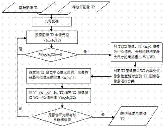
[0018] Example 1, see figure 1 , a method for repairing missing data of remote sensing images based on multi-image local interpolation, comprising the following steps:

[0019] The first step is to geometrically register the basic image T1 without missing data (called the basic image) with the image T2 to be repaired with missing data; the missing data of the remote sensing image refers to the remote sensing sensor software, hardware failure or artificial There are some missing pixels in the image caused by factors;

[0020] The second step is to search for all pixels with missing data in the image T2 to be repaired with missing data;

[0021] The third step is to record the number of rows and columns (y, x) or latitude and longitude coordinates (lon, lat) of the pixels currently missing data in the image to be repaired T2, and use the number of rows and columns (y, x) in the basic image T1 and the image to be repaired T2 x) or latitude and longitude coordinate value (lon, l...


PUM


Abstract

The invention discloses a remote sensing image missing data restoration method based on multi-image local interpolation. According to the method, based on the principle that satellite remote sensing image pixels and identical ground object pixels within a local range around the satellite remote sensing image pixels have similar spectral features, a missing data pixel is searched for in a to-be-restored image, and windows with a preset maximum search size are constructed respectively with the location of the pixel and the location of a corresponding pixel in a non-missing-data image being center points; the spectral features of pixels, corresponding to pixels with values in the window of the to-be-restored image, in the non-missing-data image are classified in the non-missing-data image to determine the location of the pixel in a minimum spectral difference with the center pixel; the spectral value of the pixel at the same location in the window of the to-be-restored image is used to replace a missing spectral value of the center point pixel in the window of the to-be-restored image; and the non-missing-data image is adopted to determine whether the missing data pixel in the to-be-restored image is the same as a certain non-missing-data pixel in a local window or has a maximum spectral similarity, and the spectral value of the non-missing-data pixel is used to fill up the spectral value of the missing data pixel. In this way, complicated calculation such as regression statistical analysis, image segmentation and geostatistical analysis on the to-be-restored image is avoided, and the method has the advantages that calculation efficiency is moderate, restoration precision is high, and the method is fast and easy to realize.

Description

Technical field: [0001] The invention relates to the technical field of image computer restoration, in particular to a method for repairing missing data of remote sensing images based on multi-image local interpolation. This method is based on the fact that spatially adjacent pixels in remote sensing images are usually similar ground objects, so spatially adjacent pixels usually have strong spectral similarity. Class relationship or spectral similarity, estimate the value of the missing data pixel in the image to be filled; the invention can be used to quickly and effectively repair the missing data in the remote sensing image, improve the utilization rate of the remote sensing image, and is based on multi-temporal remote sensing Time-series analysis of images provides a restoration and correction method for basic data. Background technique: [0002] At present, there are thousands of land resource remote sensing satellites in the world, and the images of the earth's surfac...

Claims


Application Information

Patent Timeline
IPC IPC(8): G06T5/00
CPCG06T5/005G06T2207/10032
Inventor 王涛顾丽娟张振华蒋卫国吴孟泉
Owner LUDONG UNIVERSITY
Why Eureka
Try Eureka