Unmanned plane image geometric processing method giving consideration to precision and speed

A processing method, UAV technology, applied in the geometric processing of UAV images, taking into account the accuracy and speed of UAV image geometry processing field, can solve the problem of slow speed, to reduce time-consuming, ensure accuracy, with geographic The effect of coordinates

Active Publication Date: 2017-12-29
宁夏空间信息科技有限公司
View PDF3 Cites 15 Cited by
  • Summary
  • Abstract
  • Description
  • Claims
  • Application Information

AI Technical Summary

Problems solved by technology

Since it only needs to match the UAV image with the historical reference map in the corresponding range, this method also overcomes the problem of slow speed caused by blind matching based on the method of feature matching between images, and is a method that takes both speed and accuracy into account. improvement method

Method used


Image

  • Unmanned plane image geometric processing method giving consideration to precision and speed
  • Unmanned plane image geometric processing method giving consideration to precision and speed

Examples


Embodiment Construction

[0044] The following is a further description of the technical solution of a UAV image geometry processing method with both accuracy and speed in combination with the accompanying drawings, so that those skilled in the art can better understand the present invention and implement it.

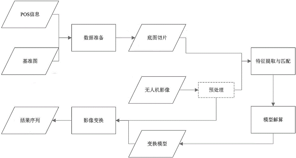
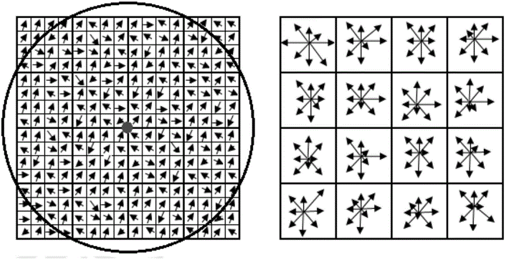
[0045] see Figure 1 to Figure 2 , a UAV image geometry processing method that takes into account both accuracy and speed provided by the present invention, adopts a method based on historical reference map matching, the method goes through: data preprocessing, data preparation (coverage estimation and historical reference map slicing), feature Extraction and matching, RANSAC error removal, model solution. The key links involved are: UAV image ground coverage estimation, SIFT feature extraction and matching, RANSAC gross error elimination, model solution and image resampling. The specific process of the model solution is to use the matching results to establish a fitting polynomial or a triangu...


PUM


Abstract

The invention provides an unmanned plane image geometric processing method giving consideration to precision and speed, and the method is a method improved based on historical reference image matching, makes the most of the precision of a historical reference images, and aims at directly registering an unmanned plane image to a historical reference image coordinate system in a feature matching mode through a historical DOM or a historical reference image of the same region. The method maintains the flexibility of the feature matching mode, and also guarantees the precision of a product through the historical reference image. Because the method just needs the matching of the unmanned plane image with the historical reference image in the corresponding range, the method also solves a problem that a method based on image feature matching is low in speed because of blind matching, and is a method giving consideration to the speed and precision. The method is quick, enables the image to have the geographic coordinates, is high in precision, can achieve the real-time previewing, and can achieve the control of distortion.

Description

technical field [0001] The invention relates to a geometric processing method of an unmanned aerial vehicle image, in particular to a geometric processing method of an unmanned aerial vehicle image taking into account both precision and speed, and belongs to the technical field of unmanned aerial vehicle image processing. Background technique [0002] In recent years, drones have been widely used in emergency incidents and have great advantages. It is mainly manifested in the occurrence of floods, earthquakes and other disasters. Usually, the transportation and communication facilities in the disaster area will be damaged to varying degrees, or even completely destroyed. At this time, external personnel cannot enter the disaster area to conduct actual investigations, and personnel in the disaster area cannot communicate with the outside world. Even if the transportation, communication and other facilities can operate normally, it is impossible to obtain a detailed and compre...

Claims


Application Information

Patent Timeline
Patent Type & Authority Applications(China)
IPC IPC(8): G06T5/00G06T7/30
CPCG06T5/006G06T7/30G06T2207/10016
Inventor 扆冰礼车雨琴扆冰蕾
Owner 宁夏空间信息科技有限公司
Why Eureka
Try Eureka