
Method for establishing heavy metal content space model of coal mining area

A technology of spatial model and establishment method, which is applied in special data processing applications, instruments, electrical digital data processing, etc., can solve the problems of ineffective evaluation of soil heavy metal pollution characteristics in coal mining areas, unreasonable data, etc., so as to improve the effective rationality, Effects with high research value and strong feasibility

Pending Publication Date: 2018-01-05
ANHUI ACADEMY OF ENVRIONMENTAL SCIENCE RESEARCH
View PDF2 Cites 10 Cited by
  • Summary
  • Abstract
  • Description
  • Claims
  • Application Information

AI Technical Summary

Problems solved by technology

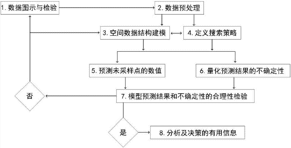
[0003] The purpose of the present invention is to provide a method for establishing a spatial model of soil heavy metal content in coal mining areas. This method can solve the problem that the existing methods cannot effectively evaluate the characteristics of heavy metal pollution in coal mining area soil, and at the same time solve the problem of the collected sample data and uncollected data of heavy metal pollution in coal mining area soil. The sample data explores data variability, finds unreasonable data, and checks the overall change trend of the data at the same time. On the basis of these data, studies the degree of spatial correlation of the regionalization variables of soil heavy metal content, and realizes the problem of preprocessing the spatial data of soil heavy metal content.

Method used


Image

  • Method for establishing heavy metal content space model of coal mining area
  • Method for establishing heavy metal content space model of coal mining area
  • Method for establishing heavy metal content space model of coal mining area

Examples


Embodiment

[0030] The establishment method of the spatial model of soil heavy metal content in the Huainan Coal Mining Area of ​​Huainan City is as follows:

[0031] The ArcGIS Geostatistical Analyst module is an extension module of ArcGIS Desktop. It is a tool for spatial data detection, determination of data anomalies, optimization of predictions, evaluation of prediction uncertainty, and generation of data planes. It can explore data variability, find unreasonable data, Check the overall change trend of the data, analyze the spatial autocorrelation and the relationship between multiple data sets, and realize the functions of spatial data preprocessing, geostatistical analysis, contour line analysis and post-processing.

[0032] Combined with the basic data of heavy metal content in Huainan mining area, the unit of statistical results is mg / kg (as shown in Table 1), and the original data of As, Cu, Zn, Cr, Ni, Cd, Pb, and Hg are skewed distribution. For the normal distribution test dat...


PUM


Abstract

The invention discloses a method for establishing the heavy metal content space model of a coal mining area. The method is characterized in comprising the step of utilizing an ArcGIS Geostatistical Analyst expansion module to research the spatial structure features of the contents and the comprehensive pollution indexes of eight heavy metals in the coal mining area. Specifically, eight steps are adopted. The contents, which are measured in the same area, of eight heavy metals and Nemerow comprehensive indexes are analyzed by two Kriging interpolation methods and eleven semivariable function models, and the contents of eight heavy metals in unmeasured areas in the same area and the Nemerow comprehensive indexes are predicted. By use of the method, data variability can be explored, unreasonable data is searched, the integral change tendency of the data is checked, the spatial correlation degree of the regionalized variable of the heavy metal content of the soil can be presented, spatialdata preprocessing is realized, decision support is provided for preventing, curing and repairing the heavy metal pollution soil of the coal mining area, and the method is suitable for the heavy metalpollution environment research of the coal mining area soil.

Description

technical field [0001] The invention relates to the technical field of environmental evaluation of heavy metal polluted soil, in particular to a method for establishing a spatial model of soil heavy metal content in a coal mining area. Background technique [0002] my country's energy structure is dominated by coal, which accounts for about 70% of primary energy consumption, and will not change in recent decades. While coal has made great contributions to my country's economic development, it has also seriously affected the soil environment in mining areas. Soil is an important natural resource of the country. How to use reasonable soil environmental assessment techniques and methods to study soil pollution in coal mining areas has far-reaching significance for the development of coal mining areas. Soil environmental quality evaluation in coal mining area can provide scientific basis for rational use of land, environmental management, environmental planning and comprehensiv...

Claims


Application Information

Patent Timeline
IPC IPC(8): G06F17/50G06Q10/04G06Q50/02
Inventor 王晓辉刘慧杜艳孙雷高翔何祥亮王宏超许克祥
Owner ANHUI ACADEMY OF ENVRIONMENTAL SCIENCE RESEARCH
Learn More