Unmanned plane remote sensing emergency monitoring and command vehicle

A technology of unmanned aerial vehicles and command vehicles, which is applied to motor vehicles, goods transport vehicles, and vehicles used for freight transportation, etc., can solve the problems of complex operation, poor compatibility of acquisition equipment and application software, and delays in the best time for emergency rescue. To achieve the effect of ensuring the car body environment

Inactive Publication Date: 2018-02-09
TIANJIN ZHONGKE REMOTE SENSING INFORMATION TECH +1
View PDF5 Cites 6 Cited by
  • Summary
  • Abstract
  • Description
  • Claims
  • Application Information

AI Technical Summary

Problems solved by technology

[0002] At present, when natural disasters occur, most departments do not have the equipment and capabilities required for remote sensing emergency monitoring, and still rely on traditional monitoring methods, which cannot provide fast and accurate guidance data for emergency decision-making departments
With the comprehensive development of remote sensing technology, remote sensing emergency monitoring capabilities are also constantly improving, but the way of data acquisition is still limited by factors such as weather, region, and traffic.
Remote sensing data acquisition equipment is too large, inconvenient to load, and complicated to operate, which limits the effective role of the equipment
At the same time, the ability to process the acquired remote sensing data is not timely enough to provide monitoring and implementation personnel with first-hand remote sensing data to detect danger and take emergency measures in time, which delays the best time for emergency rescue. In addition, various Poor compatibility between acquisition equipment and application software is also a limitation of existing equipment

Method used


Image

  • Unmanned plane remote sensing emergency monitoring and command vehicle
  • Unmanned plane remote sensing emergency monitoring and command vehicle
  • Unmanned plane remote sensing emergency monitoring and command vehicle

Examples


Embodiment Construction

[0044] The present invention will be described in further detail below through specific embodiments and in conjunction with the accompanying drawings.

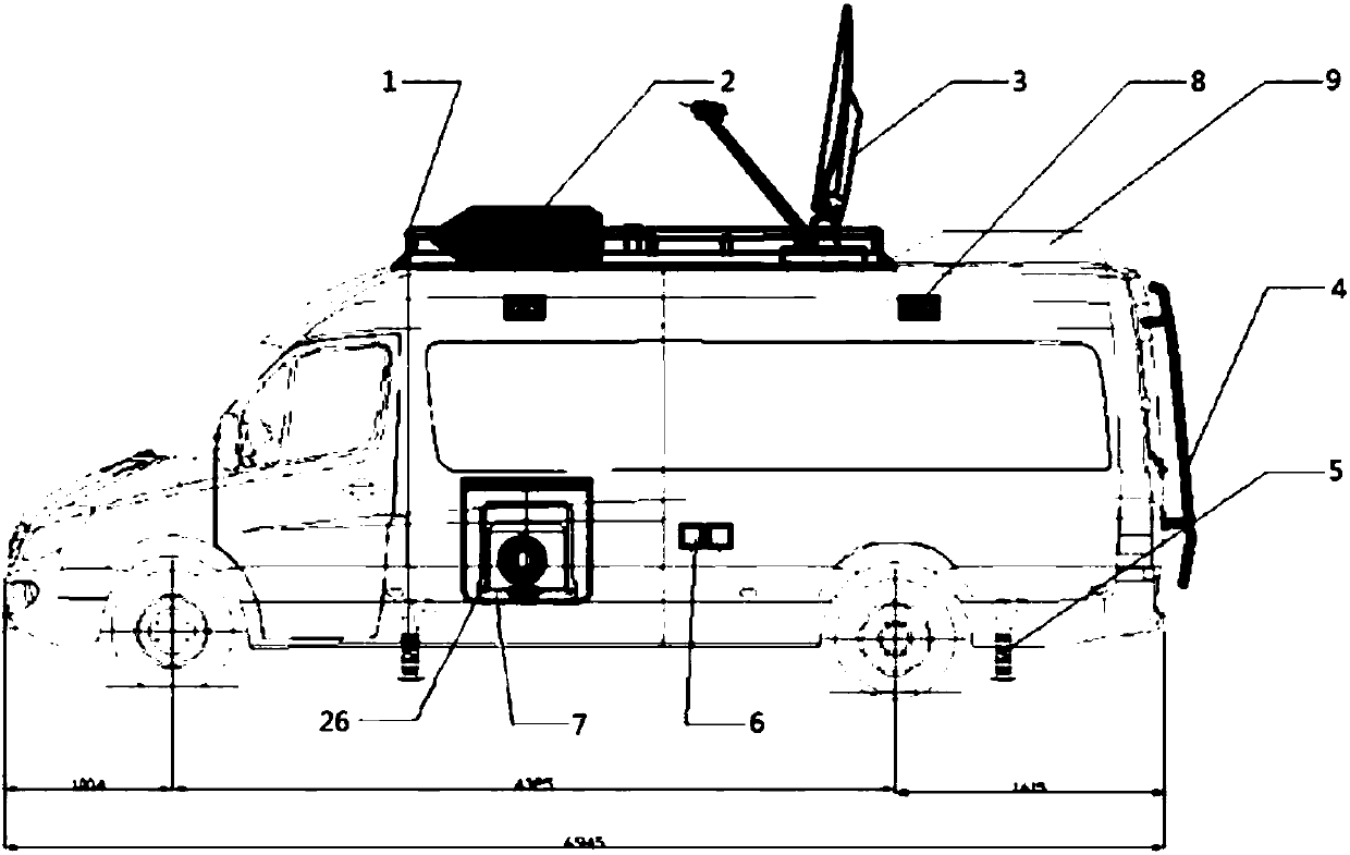
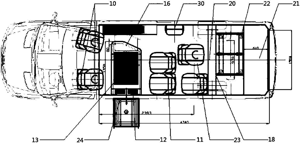
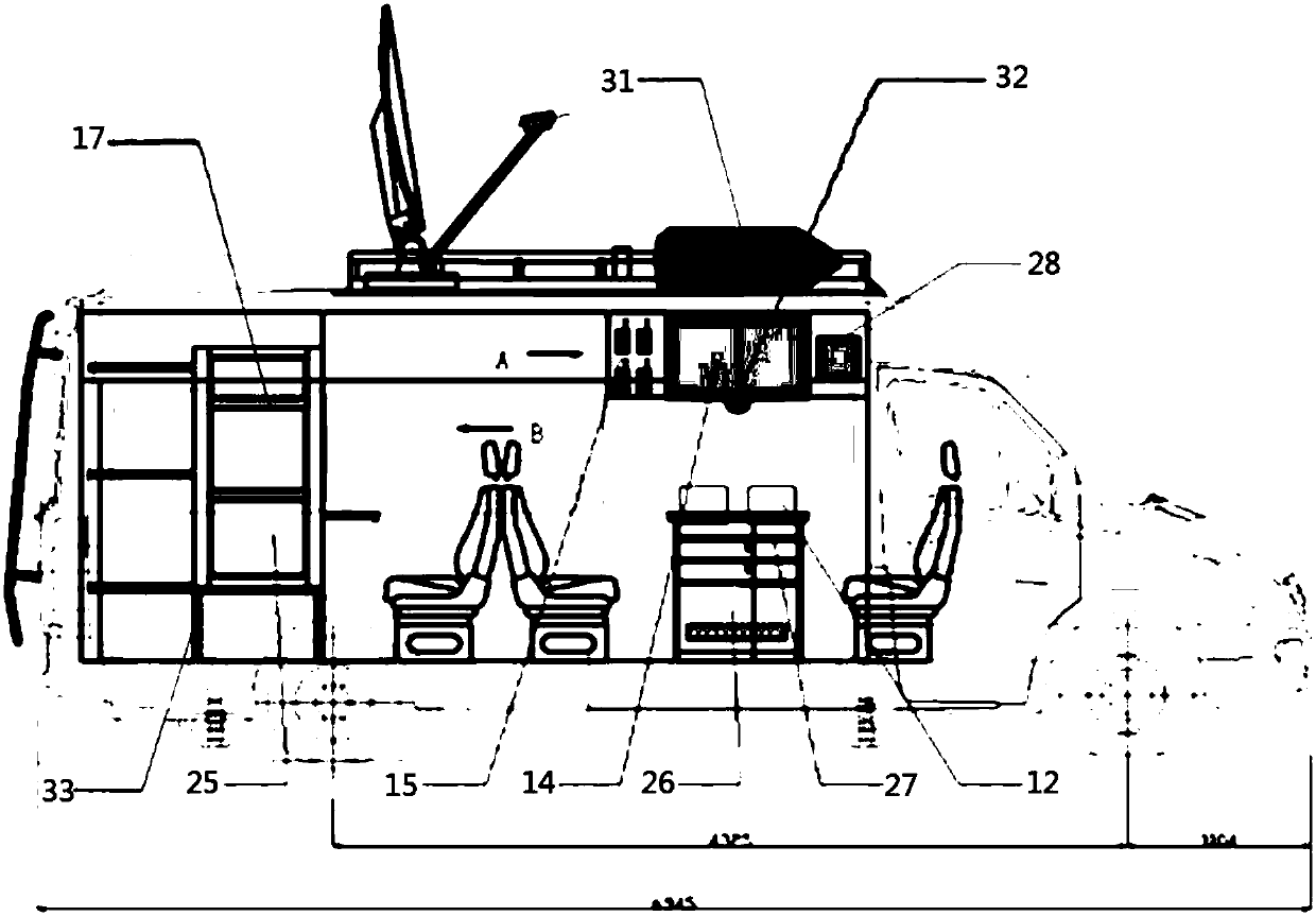
[0045] like Figure 1-4 As shown, an unmanned aerial vehicle remote sensing emergency monitoring and command vehicle described in the embodiment of the present invention is equipped with a roof platform (1), a parking air conditioner (2), a satellite antenna (3) and an awning (31) Fixed on the roof platform (1); the satellite antenna (3) can ensure access to the Internet, and can perform various information inquiries, file transfers and data exchanges; the parking air conditioner (2) is used to adjust the ambient temperature in the car , to ensure the normal operation of the instrument; the awning (31) is fixed on the outside of the right side of the roof platform, and is used to build a simple work area in the field; the climbing ladder (4) is located on the rear door of the compartment, so that the staff can climb on the roof ...


PUM


Abstract

The invention discloses an unmanned plane remote sensing emergency monitoring and command vehicle, including a roof platform, a parking air-conditioner, a satellite antenna, a climbing ladder, a chassis support, an external power supply, a power distribution room, body lights, travelling crane air-conditioner, driver and second driver seats, individual seat x 3, IPAD x 4, a touch display screen, a32'' liquid crystal screen, an interphone, a workbench, a device bracket, a partition, tail lights, a computer operation board, an equipment compartment, damping gaskets, a swivel chair, a 5 KW powergenerator, a working group equipment cabinet, a pull-push damping structure, a storage cabinet, a small liquid crystal screen, a loudspeaker, an individual folding seat, an awning, a conference maincamera, an equipment cabinet underframe, emergency communication equipment, a remote sensing data acquisition facility, data processing and output equipment, high-resolution satellite data push equipment, commanding and dispatching and news releasing equipment, and expert long-distance consultation equipment. Beneficial effects of the vehicle are that monitoring equipment required by remote sensing emergency monitoring and command is integrated in a compartment, the vehicle can comprehensively acquire and process remote sensing information in fixed points at fixed time, and provides visual data products and emergency solutions, and satisfies mobility and real-time property of emergency disaster rescue.

Description

technical field [0001] The invention relates to the technical field of aviation remote sensing emergency monitoring, in particular to an unmanned aerial vehicle remote sensing emergency monitoring and command vehicle. Background technique [0002] At present, when natural disasters occur, most departments do not have the equipment and capabilities required for remote sensing emergency monitoring, and still rely on traditional monitoring methods, which cannot provide fast and accurate guidance data for emergency decision-making departments. With the comprehensive development of remote sensing technology, remote sensing emergency monitoring capabilities are also constantly improving, but data acquisition methods are still severely limited by factors such as weather, region, and traffic. Remote sensing data acquisition equipment is too large, inconvenient to load, and complicated to operate, which limits the effective role of the equipment. At the same time, the ability to pro...

Claims


Application Information

Patent Timeline
Patent Type & Authority Applications(China)
IPC IPC(8): B60P3/00H01Q1/32
CPCB60P3/00H01Q1/3208H01Q1/3275
Inventor 王晋年丁琳黄瑶李丹李增顺郝震寰张彩霞刘净净
Owner TIANJIN ZHONGKE REMOTE SENSING INFORMATION TECH
Why Eureka
Try Eureka