Image stitching method based on unmanned aerial vehicle POS information and image SURF feature combination

A technology of image stitching and drones, applied in image enhancement, image data processing, graphics and image conversion, etc., can solve the problems of unstable posture and different errors, reduce the amount of calculation, improve detection efficiency, stitching efficiency and visual Effect of effect improvement

Inactive Publication Date: 2018-03-16
BEIJING UNIV OF TECH
View PDF2 Cites 69 Cited by
  • Summary
  • Abstract
  • Description
  • Claims
  • Application Information

AI Technical Summary

Problems solved by technology

This information records the attitude of the aircraft at each exposure moment when it is flying. However, since the attitude of the drone is not fixed when it is taking aerial photography, two sets of POS data of

Method used


Image

  • Image stitching method based on unmanned aerial vehicle POS information and image SURF feature combination
  • Image stitching method based on unmanned aerial vehicle POS information and image SURF feature combination
  • Image stitching method based on unmanned aerial vehicle POS information and image SURF feature combination

Examples


Embodiment Construction

[0028] The present invention will be further described below in conjunction with accompanying drawing;

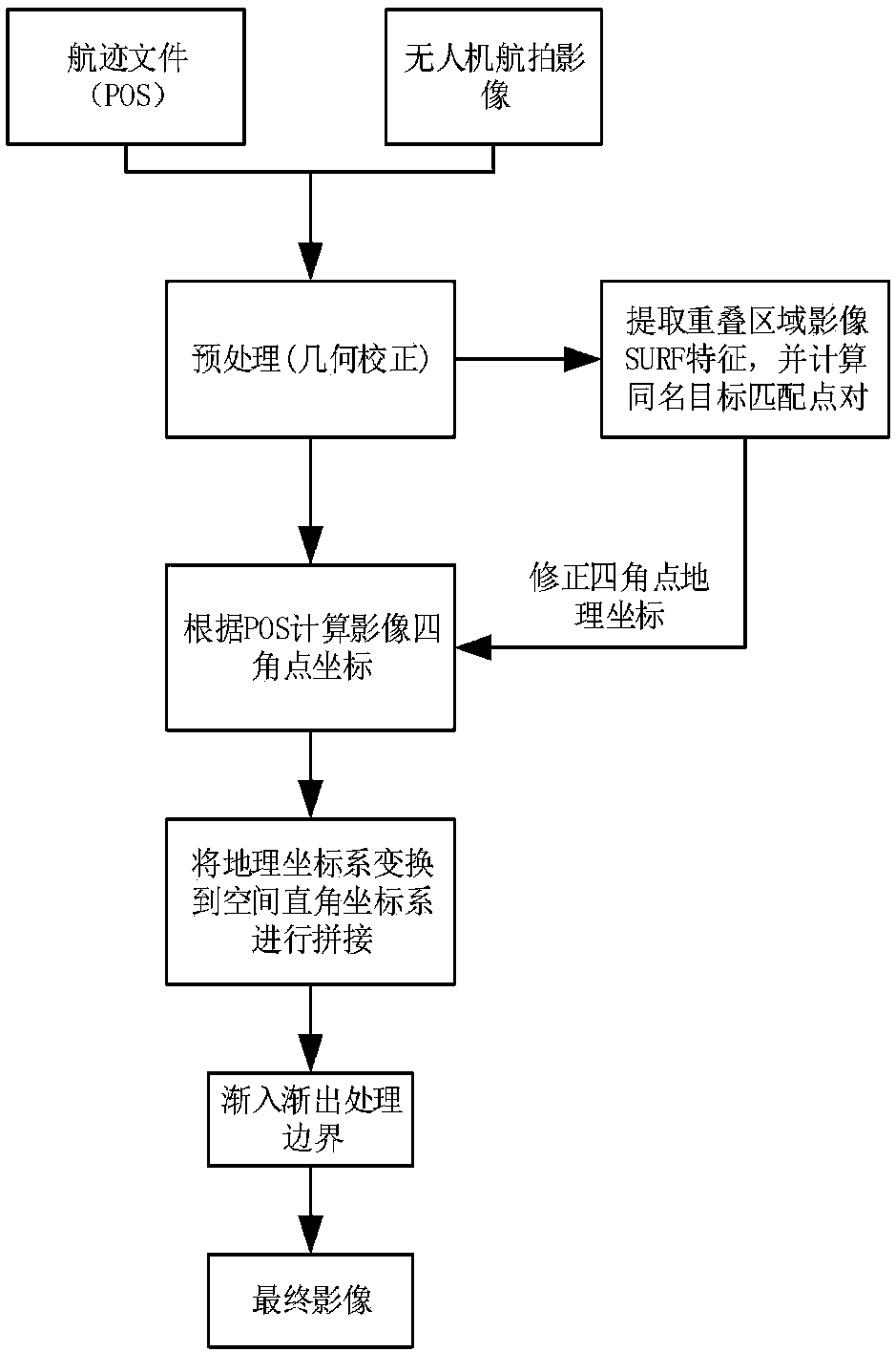
[0029] The overall process of the present invention is as figure 1 As shown, it is mainly divided into six major links: aerial image preprocessing link, aerial image overlapping area calculation link, image geographic coordinate calculation link, image SURF feature extraction link, and adjacent image SURF feature matching point pair correction link and image Fusion link. Among them, combining the adjacent image SURF feature matching points to correct the geographic coordinates of the image is the innovation layer of this method. In combination with the algorithm execution sequence, the specific implementation of the above-mentioned contents will be described below:

[0030] S1 aerial image preprocessing:

[0031] In the process of preprocessing geometric correction, the coordinate systems that need to be established in sequence are: earth coordinate system, geographic coo...


PUM


Abstract

The invention discloses an image stitching method based on unmanned aerial vehicle POS information and image SURF feature combination and relates to the digital image processing field, the GIS field,the survey field and other relevant fields. According to the method, first, geometric correction is performed on images; second, geographic coordinates of four corners of each image are calculated; based on the geographic coordinates of the first image, a position relation of homonymy matching target positions is obtained by extracting SURF features of adjacent image overlapping regions, and therefore the geographic coordinates of the following images are sequentially corrected; and last, an adaptive gradual-in-gradual-out fusion algorithm is adopted, a panoramic image with a good visual effect is obtained, and good stitching of the images is completed. Through the method, an image feature extraction algorithm and the geographic coordinates of the images are combined, and stitching efficiency and the visual effect are both improved greatly compared with traditional feature extraction and stitching algorithms; and the image obtained after stitching contains geographic information, so that the image has certain practical value.

Description

technical field [0001] The invention relates to a splicing method based on the combination of unmanned aerial vehicle POS (Position and Orientation System) information and image SURF features, and belongs to the fields of digital image processing, GIS, surveying and mapping, and other related fields. Background technique [0002] UAV (Unmanned Aerial Vehicle) has the characteristics of simple operation, quick response, flexible flight, and low cost. It has been widely used in disaster relief, military reconnaissance, maritime detection, environmental protection, and land dynamic monitoring. However, due to the limited viewing angle of UAV aerial photography sequence pictures, it is limited by the flying height of UAV and the parameters of the camera. In order to fully grasp and analyze the captured area and get more information about the target area, it is very urgent and necessary to quickly stitch images. [0003] At present, there are two main methods for stitching aeria...

Claims


Application Information

Patent Timeline
IPC IPC(8): G06T3/00G06T3/40G06T5/50G06T5/00
CPCG06T3/0068G06T3/4038G06T5/006G06T5/50
Inventor 赵德群王亚洲孙光民邓钱华
Owner BEIJING UNIV OF TECH
Why Eureka
Try Eureka