Collaborative synchronous positioning and map building method and system and interactive system

A technology for synchronous positioning and map construction, which is applied in transmission systems, 3D modeling, surveying and navigation, etc., and can solve problems that are only reflected in map construction, no SLAM information is stored, and data frame synchronization is difficult to achieve.

Active Publication Date: 2018-03-20
BEIJING HUAJIE IMI TECH CO LTD
View PDF9 Cites 25 Cited by
  • Summary
  • Abstract
  • Description
  • Claims
  • Application Information

AI Technical Summary

Problems solved by technology

This method has the following disadvantages: on the one hand, the method assumes that all cameras observe the same initial scene during initialization, which greatly limits the flexibility of the method and makes initialization very difficult; on the other hand, the same frame of different cameras There are two problems in re-triangulation of 3D positions and tracking feature points. One is that the synchronization of data frames is difficult to achieve. Reflected in map construction, task collaboration between devices cannot be realized
This method has the following deficiencies: on the one hand, the implementation method of the wide-area map referred to

Method used


Image

  • Collaborative synchronous positioning and map building method and system and interactive system
  • Collaborative synchronous positioning and map building method and system and interactive system
  • Collaborative synchronous positioning and map building method and system and interactive system

Examples


Embodiment Construction

[0093] Specific embodiments of the present invention will be described in detail below in conjunction with the accompanying drawings. It should be understood that the specific embodiments described here are only used to illustrate and explain the present invention, and are not intended to limit the present invention.

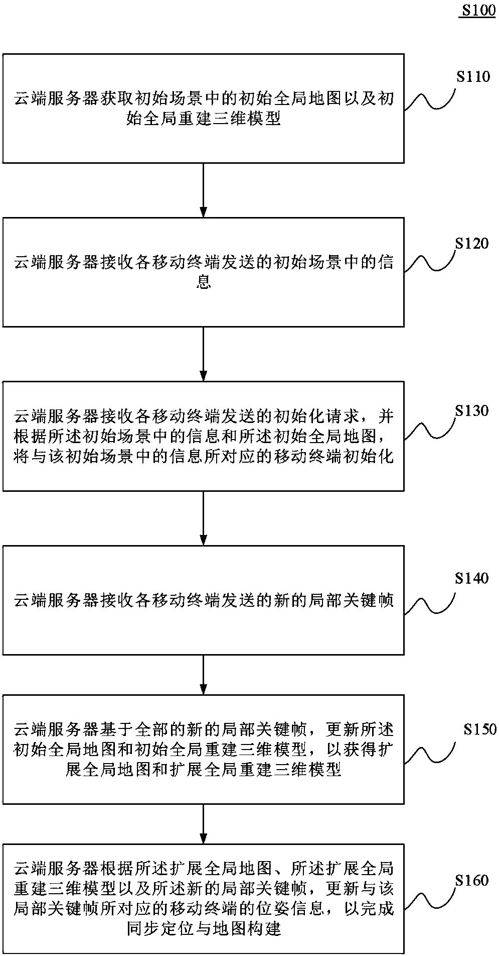
[0094] Such as figure 1 As shown, it is a flowchart of a collaborative synchronous positioning and map construction method S100 in the first embodiment of the present invention, and the method S100 includes:

[0095] S110. The cloud server acquires an initial global map and an initial global reconstructed 3D model in the initial scene.

[0096] Specifically, in this step, the initial scene may be the target scene or a part of the target scene of the following collaborative synchronous positioning and map construction system, but the initial scene itself is not too limited, and may be a part of the indoor area or a A room, or something larger than a room, such ...


PUM


Abstract

The invention discloses a collaborative synchronous positioning and map building method and system and an interactive system. The method comprises the steps: enabling a cloud server to obtain an initial global map in an initial scene and an initial global constructed three-dimensional model; receiving the information and initialization requests, sent by all mobile terminals, in the initial scene,and initializing the mobile terminal corresponding to the information in the initial scene according to the information and initial global map in the initial scene; receiving a new local key frame sent by each mobile terminal, updating the initial global map and the initial global constructed three-dimensional model, so as to obtain an extended global map and an extended global constructed three-dimensional model; updating the posture information of the mobile terminal corresponding to the local key frame according to the extended global map, the extended global constructed three-dimensional model and the new local key frame, so as to complete the synchronous positioning and map reconstruction. The method can achieve the cooperative work of all mobile terminals, and is very high in real-time performance, stability and robustness of a system.

Description

technical field [0001] The present invention relates to the technical field of synchronous positioning and map construction, in particular to a method for collaborative synchronous positioning and map construction, a system for cooperative synchronous positioning and map construction, and an interactive system for cooperative synchronous positioning and map construction. Background technique [0002] At present, Simultaneous Localization and Mapping (SLAM, Simultaneous Localization And Mapping) is a technology that enables mobile devices to automatically create maps in unknown environments and perform self-positioning based on estimates of their own state and maps. With robots, virtual reality (VR, Virtual Reality) and augmented reality (AR, AugmentReality) in recent years [0003] With the rapid development of SLAM technology, more and more attention has been paid to it. SLAM technology itself is not very mature. It has technical difficulties such as high algorithm complex...

Claims


Application Information

Patent Timeline
IPC IPC(8): G06T17/05G01C21/00H04L29/08
CPCH04L67/10G06T17/05G01C21/005
Inventor 王行周晓军李骊盛赞李朔
Owner BEIJING HUAJIE IMI TECH CO LTD
Why Eureka
Try Eureka