A design method and system of a cable pipeline laying project based on a geographic information system

A geographic information system and basic geographic information technology, applied in computer-aided design, calculation, electrical digital data processing, etc., can solve the gap between the accuracy and accuracy of underground detection and detection technology, increase the digital design of cable engineering, and the foundation of cable engineering Data inconsistency and other issues can be avoided to achieve the effect of avoiding on-site changes, digitizing design results, and realizing standardization

Pending Publication Date: 2019-01-08
CHINA ELECTRIC POWER RES INST +2
View PDF0 Cites 11 Cited by
  • Summary
  • Abstract
  • Description
  • Claims
  • Application Information

AI Technical Summary

Problems solved by technology

In the traditional cable engineering design, after the design work starts, the majors raise and collect funds from each other, and after modifying the drawings and adjusting the design, they have to raise and collect funds again, repeating the above steps, resulting in poor interaction of basic information , Insufficient synergy and inheritance, resulting in reduced design quality and efficiency
[0004] At present, the digital collaborative design of cable engineering is still in the exploratory stage, and the basic data of cable engineering does not match the site, and there is a certain gap in the accuracy and precision of underground detection and detection technology. design increases the difficulty

Method used


Image

  • A design method and system of a cable pipeline laying project based on a geographic information system
  • A design method and system of a cable pipeline laying project based on a geographic information system
  • A design method and system of a cable pipeline laying project based on a geographic information system

Examples


Embodiment 1

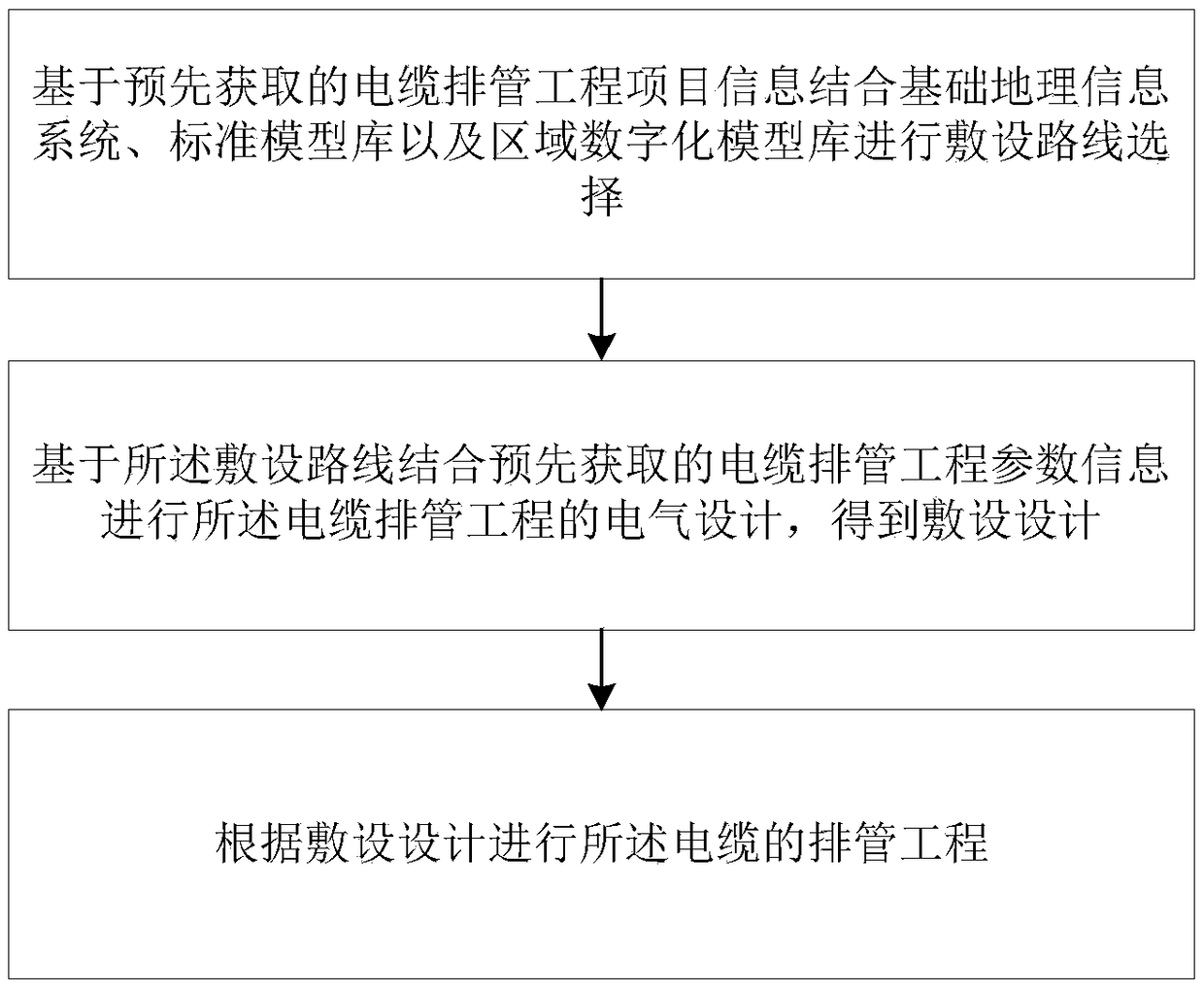
[0074] Such as figure 1 ,include:

[0075] S1. Select the laying route based on the pre-acquired cable piping project information combined with the basic geographic information system, standard model library and regional digital model library;

[0076] S2. Perform electrical design of the cable conduit project based on the laying route combined with pre-acquired cable conduit project parameter information to obtain a laying design;

[0077] S3. Carry out the cable pipe arrangement project according to the laying design.

[0078] Specific as figure 2 as shown,

[0079] S1 further includes:

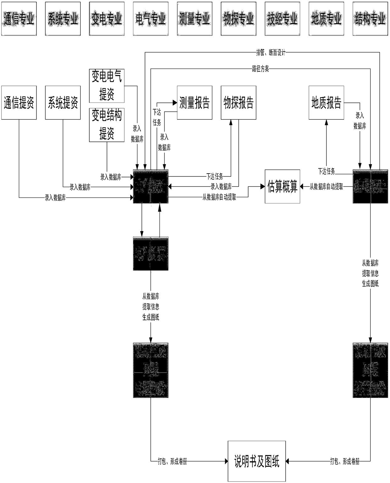
[0080] Step 1. Create a new cable piping project, collect project-related materials and information, and conduct unified management in the digital collaborative design system; determine the designers of each major participating in the project, and determine the authority of personnel at all levels participating in the project;

[0081] Among them, the information includes: general reg...

Embodiment 2

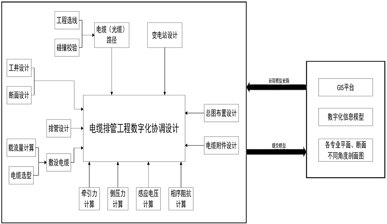
[0159] Based on the unified inventive concept, a geographical information system-based cable pipe engineering design system proposed by the present invention is similar to a geographical information system-based cable pipe engineering design method, including:

[0160] Line selection module, collaborative design module and engineering design module;

[0161] The following is a further description of the above three modules:

[0162] The route selection module is used to select the laying route based on the pre-acquired cable pipe engineering project information combined with the basic geographic information system, standard model library and regional digital model library;

[0163] The collaborative design module is used to perform the electrical design of the cable conduit project based on the laying route combined with the pre-acquired cable conduit project parameter information, and obtain the laying design;

[0164] Engineering design module, which is used to carry out ca...


PUM


Abstract

The invention relates to a design method and system of a cable pipeline laying project based on a geographical information system. The method comprises the following steps: carrying out laying route selection based on pre-acquired cable pipe laying project information combined with a basic geographical information system, a standard model library and a regional digital model library; carrying outelectrical design of the cable pipe laying project based on the laying route and the pre-acquired parameter information of the cable pipe laying project, and obtaining a laying design; according to the laying design, carrying out the pipeline drainage works of the cable. The technical scheme of the invention completes the digitalized cooperative design of the cable pipe arrangement project, realizes the standardization of the design object, the visualization of the design process, the collaborative design flow, the digitalization of the design result, the accuracy, convenience, the advanced technology and the like.

Description

technical field [0001] The invention belongs to the field of cable engineering, and in particular relates to a method and system for designing a cable pipe arrangement project based on a geographic information system. Background technique [0002] At present, the design of cable engineering mainly adopts the two-dimensional design method of AutoCAD, and the display of cable engineering results uses electronic documents and drawings in DWG format. Although the use of computer graphics can increase the accuracy and aesthetics of the design, and improve the portability of design results and repeated applications, this design method does not change the design process in essence, but only cancels the drawing link; In terms of management, only electronic graphics files have been added. Since the design drawings are still isolated data and various types of data have not been structured, the operations of information extraction, statistics, query, and analysis are relatively diffic...

Claims


Application Information

Patent Timeline
Patent Type & Authority Applications(China)
IPC IPC(8): G06F17/50
CPCG06F30/00G06F2113/14
Inventor 白旭周纬费香泽金欢王剑侯林波
Owner CHINA ELECTRIC POWER RES INST
Why Eureka
Try Eureka