Method and equipment for synchronous positioning and map establishing

A map construction and synchronous positioning technology, applied in structured data retrieval, geographic information database, design optimization/simulation, etc., can solve the problems of high calculation and storage space requirements, reduce storage and retrieval time, and simplify calculation The effect of increasing the quantity and improving the convenience

Active Publication Date: 2018-04-17
SUZHOU AGV ROBOT CO LTD
View PDF10 Cites 23 Cited by
  • Summary
  • Abstract
  • Description
  • Claims
  • Application Information

AI Technical Summary

Problems solved by technology

In this way, from the perspective of computational feasibility, the space complexity and time complexity increase with the increase of cells, so its main disadvantage is the high calculation and storage space requirements for positioning.

Method used


Image

  • Method and equipment for synchronous positioning and map establishing
  • Method and equipment for synchronous positioning and map establishing

Examples


Embodiment Construction

[0023] The following will clearly and completely describe the technical solutions in the embodiments of the present invention with reference to the accompanying drawings in the embodiments of the present invention. Obviously, the described embodiments are only some, not all, embodiments of the present invention. Based on the embodiments of the present invention, all other embodiments obtained by persons of ordinary skill in the art without making creative efforts belong to the protection scope of the present invention.

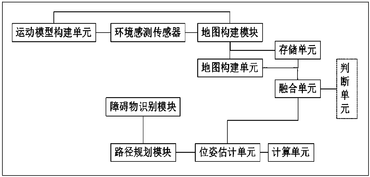
[0024] Such as figure 1 , figure 2 As shown, a method for synchronous positioning and map construction of the present invention is used for robots. It is characterized in that the map construction method includes the steps of: loading a pre-established robot kinematics model; Assume that an initial global map is established in the coordinate system, and the initial global map is represented by several geometric primitives, the geometric primitives are store...


PUM


Abstract

The invention discloses a method and equipment for synchronous positioning and map establishing. The method and the equipment are applied to robots. The map establishing method comprises the followingsteps: loading a preset robot dynamitic model; scanning an environment by using an environment sensor, establishing an initial global map in a preset coordinate system, expressing the initial globalmap by a plurality of geometric prototypes, storing the geometric prototypes in a same sequence, and marking with storage serial numbers; when being moved to a current position, scanning by using theenvironment sensor so as to obtain a current partial map, expressing the current partial map by using a plurality of geometric prototypes, storing the geometric prototypes in a sequence identical to that of the initial global map, marking with storage serial number, and combining according to comparison of the geometric prototype storage serial numbers of the current partial maps and the initial global map so as to obtain an updated global map; and according to the current partial maps, the initial global map and the updated global map, estimating a current posture of a robot. The calculationamount of map establishment is effectively simplified, and the storage space is effectively reduced.

Description

technical field [0001] The invention relates to the field of mobile robot navigation, in particular to a method for synchronous positioning and map construction. Background technique [0002] The simultaneous localization and mapping (SLAM) problem of autonomous mobile robots can be described as: in an unknown environment, mobile robots use airborne environment sensing sensors (such as odometers, visual environment sensing sensors, ultrasonic and laser, etc.) Perceive environmental information, gradually build a map of the surrounding environment, and use this map to estimate its position and attitude. This problem has always been a hot and difficult point in the field of mobile robot research. It is considered to be the key issue of whether the robot can truly realize autonomous navigation, and has broad application prospects. [0003] The existing map construction methods are mainly grid-based maps, which are also called occupancy grid (evidence grid) maps. For a grid ma...

Claims


Application Information

Patent Timeline
Patent Type & Authority Applications(China)
IPC IPC(8): G01C21/20G06F17/30G06F17/50
CPCG01C21/20G06F16/29G06F30/20
Inventor 刘胜明司秀芬姜志英
Owner SUZHOU AGV ROBOT CO LTD
Why Eureka
Try Eureka