A method, system and electronic equipment for land use planning based on machine vision

A technology of machine vision and topography, applied in computer parts, biological neural network models, calculations, etc., to achieve the effect of reducing computing performance requirements, being able to be extensive, and reducing the amount of calculations

Active Publication Date: 2022-03-22
SHENZHEN INST OF ADVANCED TECH CHINESE ACAD OF SCI
View PDF5 Cites 0 Cited by
  • Summary
  • Abstract
  • Description
  • Claims
  • Application Information

AI Technical Summary

Problems solved by technology

However, the planning of agricultural reclamation and forest land use based on machine learning object recognition and segmentation technology is still blank

Method used


Image

  • A method, system and electronic equipment for land use planning based on machine vision
  • A method, system and electronic equipment for land use planning based on machine vision
  • A method, system and electronic equipment for land use planning based on machine vision

Examples


Embodiment Construction

[0097] In order to make the purpose, technical solution and advantages of the present application clearer, the present application will be further described in detail below in conjunction with the accompanying drawings and embodiments. It should be understood that the specific embodiments described here are only used to explain the present application, not to limit the present application.

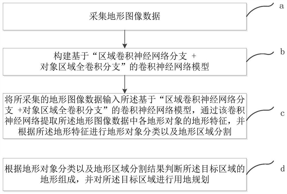
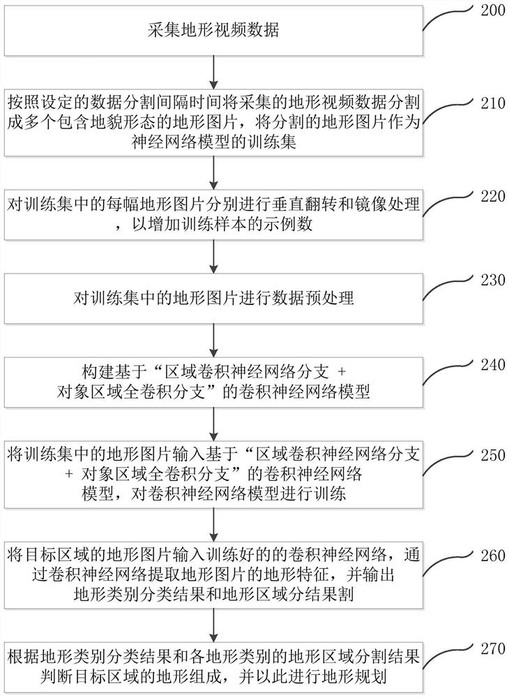
[0098] see figure 1 , is a flow chart of the machine vision-based land use planning method according to the first embodiment of the present application. The land use planning method based on machine vision according to the first embodiment of the present application includes the following steps:

[0099] Step a: collecting terrain image data of the target area;

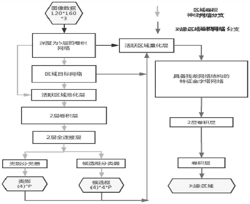
[0100] Step b: Construct a convolutional neural network model based on "area convolutional neural network branch + object area full convolution branch";

[0101] Step c: Input the collected topographic image data into the convo...


PUM


Abstract

The present application relates to the technical field of terrain segmentation and recognition, in particular to a machine vision-based land use planning method, system and electronic equipment. The method includes: collecting topographic image data of the target area; constructing a convolutional neural network model based on "regional convolutional neural network branch + object area full convolution branch"; inputting the collected topographic image data into the "area-based The convolutional neural network model of "convolutional neural network branch + object area full convolution branch", through which the convolutional neural network model extracts the terrain features of each terrain object in the terrain image data, and performs terrain object processing according to the terrain features. Classification and terrain area segmentation: judging the terrain composition of the target area according to the terrain object classification and terrain area segmentation results, and performing land use planning for the target area. This application saves a large number of manual outdoor surveying and mapping operations, and has few restrictions on application scenarios, can be widely used, and has high recognition accuracy.

Description

technical field [0001] The present application relates to the technical field of terrain segmentation and recognition, in particular to a machine vision-based land use planning method, system and electronic equipment. Background technique [0002] Image processing and computer vision refer to the use of cameras and computers instead of human eyes to identify, track and measure machine vision, and further use computers for image processing to generate images that are more suitable for human eyes to observe or sent to instruments for detection. [0003] The application of machine learning has the advantages of high accuracy and fast recognition speed in image (video) recognition. Machine learning is a branch of artificial intelligence. The research of artificial intelligence is a natural and clear thread from focusing on "reasoning" to focusing on "knowledge" and then focusing on "learning". Obviously, machine learning is a way to realize artificial intelligence, that is, us...

Claims


Application Information

Patent Timeline
Patent Type & Authority Patents(China)
IPC IPC(8): G06V10/26G06V10/40G06N3/04
CPCG06V10/267G06V10/40G06N3/045
Inventor 王书强曹松王祖辉胡明辉王鸿飞
Owner SHENZHEN INST OF ADVANCED TECH CHINESE ACAD OF SCI
Why Eureka
Try Eureka