Plant protection operation method based on lidar surveying and mapping

A laser radar and plant protection technology, applied in the field of drones, can solve problems such as lack of flight, division of operating range, and missing flight, and achieve the effects of reducing the difference in area size, improving operating efficiency, and a high degree of automation

Inactive Publication Date: 2018-04-27
CHENGDU SKYLIN TECH CO LTD
View PDF11 Cites 13 Cited by
  • Summary
  • Abstract
  • Description
  • Claims
  • Application Information

AI Technical Summary

Problems solved by technology

When carrying out large-scale plant protection operations, the specific surveying and mapping scheme is usually determined by the operator according to the site environment. However, when the operation area is too large, the operation range cannot be accurately divided according to the above method, and defects are prone to occur. The situation of flying and missing flying seriously affected the effect of the operation; at the same time, surveying and mapping were carried out before each operation, which affected the efficiency of plant protection operations

Method used


Image

  • Plant protection operation method based on lidar surveying and mapping

Examples


Embodiment Construction

[0039] In order to make the object, technical solution and advantages of the present invention clearer, the present invention will be further described in detail below in conjunction with the accompanying drawings.

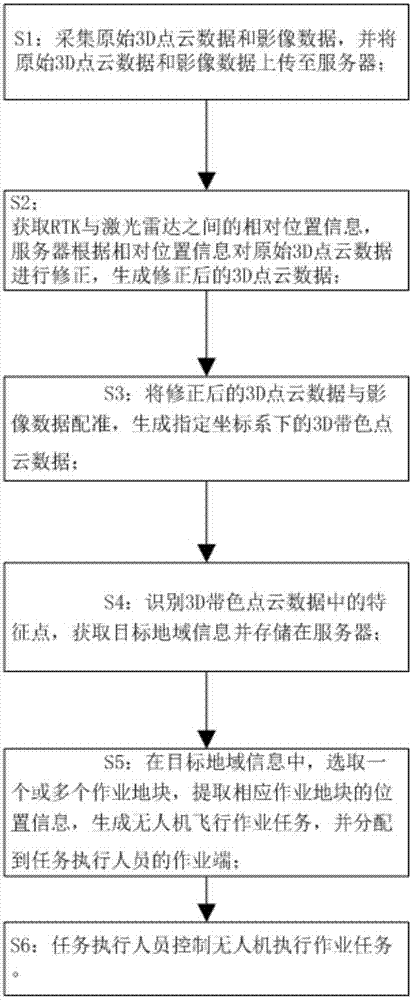
[0040] In this example, if figure 1 As shown, a plant protection operation method based on lidar surveying and mapping includes the following steps:

[0041] The airborne lidar and camera device reciprocally scan the target area, collect the original 3D point cloud data and image data, and upload the original 3D point cloud data and image data to the server; according to the requirements for surveying and mapping data, set the appropriate parameters (such as scanning frequency, flight altitude, etc.), use the airborne lidar system to collect three-dimensional space data of the target area, and obtain the original point cloud data. The existing airborne lidar system integrates an aerial digital camera, which can Aerial images are acquired synchronously with point ...


PUM


Abstract

The invention discloses a plant protection operation method based on lidar surveying and mapping, which comprises the following steps: an airborne lidar and a photographing device perform reciprocating scanning on a target region, original 3D point cloud data and image data are acquired, and the original 3D point cloud data and the image data are uploaded to a server; the relative position information between an RTK and the lidar is acquired, the server corrects the original 3D point cloud data according to the relative position information, and corrected 3D point cloud data are generated, wherein the feature points in the corrected 3D point cloud data carry RTK coordinate information. According to the plant protection operation method based on lidar surveying and mapping, the surveying and mapping result can be repeatedly extracted and used, surveying and mapping again in an operation block in the same region are not needed, and the plant protection operation can be carried out directly without relying on a base station; and the operation range of an unmanned aerial vehicle can be accurately segmented, task dispatching and distributing are completed, and the operation efficiency is ensured.

Description

technical field [0001] The invention relates to the technical field of unmanned aerial vehicles, in particular to a plant protection operation method based on laser radar surveying and mapping. Background technique [0002] At present, with the land transfer and the gradual scale of agricultural land production, in order to improve the efficiency of agricultural production and reduce the cost of agricultural production, there is an increasing demand for drones to spray pesticides and other operations with drones. In the prior art, whenever the UAV needs to perform plant protection operations, operators are required to conduct on-site surveying and mapping, and perform plant protection operations according to the surveying and mapping results. When carrying out large-scale plant protection operations, the specific surveying and mapping scheme is usually determined by the operator according to the site environment. However, when the operation area is too large, the operation r...

Claims


Application Information

Patent Timeline
Patent Type & Authority Applications(China)
IPC IPC(8): G01S17/89G01S17/02G01C11/00
CPCG01C11/00G01S17/86G01S17/89
Inventor 杨凌文朋
Owner CHENGDU SKYLIN TECH CO LTD
Why Eureka
Try Eureka