Satellite positioning method in urban canyons based on 3D urban model assistance

A city model and urban canyon technology, applied in the field of satellite positioning and navigation, can solve the problems of low reliability, insufficient accuracy of satellite signal reception type state judgment algorithm, multi-path signal correction model calculation efficiency and positioning performance need to be improved, etc., to achieve The effect of improving accuracy

Active Publication Date: 2018-04-27
NANJING UNIV OF AERONAUTICS & ASTRONAUTICS
View PDF4 Cites 23 Cited by
  • Summary
  • Abstract
  • Description
  • Claims
  • Application Information

AI Technical Summary

Problems solved by technology

[0008] The purpose of the present invention is to address the deficiencies of the above-mentioned background technology, to provide a satellite positioning method in urban canyons based on 3D city model assistance, to realize the reliable excavation of the judgment rule of satellite receiving signal type, and to solve the

Method used


Image

  • Satellite positioning method in urban canyons based on 3D urban model assistance

Examples


Embodiment Construction

[0018] The technical solution of the invention will be described in detail below in conjunction with the accompanying drawings.

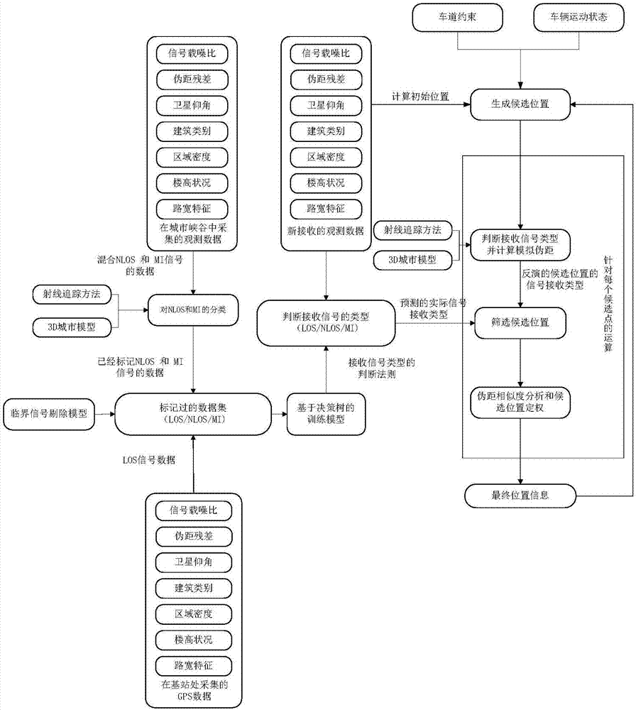
[0019] The specific scheme of the satellite positioning method in the urban canyon based on the 3D city model is as follows: figure 1 As shown, it includes the following six steps.

[0020] (1) Judgment rule for extracting received signal type

[0021] Collect data in different scenarios (open areas, urban canyons) to build a historical training data set, which is comprehensively composed of signal carrier-to-noise ratio, pseudorange residual, satellite elevation angle, urban building type, regional density, building height, road width characteristics, etc. The information evaluation index constitutes the historical training data set; the data collected from the base station located in the open area is marked as LOS; for the data collected in the densely built "urban canyon", the type of satellite reception signal is judged by 3D city model and ray...


PUM


Abstract

The invention discloses a satellite positioning method in urban canyons based on 3D urban model assistance. The satellite positioning method belongs to the technical field of satellite positioning andnavigation. According to the satellite positioning method, data is acquired in different scenarios to generate a historical training data set and threshold signals are eliminated, a reliable satellite signal reception type judging rule is generated by means of a decision-making tree, candidate positions are screened through comparing an inversion result of a candidate position received signal type and a judging rule prediction result, a final positioning result is determined through correcting errors caused by multi-path and non-line-of-sight received signals by adopting a method based on pseudo-range similarity, and the precision of satellite positioning in the urban canyons is improved.

Description

technical field [0001] The invention discloses a satellite positioning method in an urban canyon aided by a 3D city model, and belongs to the technical field of satellite positioning and navigation. Background technique [0002] Global Navigation Satellite System (GNSS, Global Navigation Satellite System), as the core component of vehicle navigation system, can obtain vehicle location and dynamic information in real time. However, in the urban canyon environment, due to the influence of tall buildings, overpasses and trees, its navigation system There are still some problems in the accuracy and reliability. [0003] When the GNSS signal is not blocked, the received signal is line-of-sight (LOS, Line-of-Sight). However, due to the dense buildings in the urban environment, GNSS is seriously affected by multipath effects. Multipath effects can be divided into multipath interference (MI, Multipath Interference) and non-line-of-sight reception (NLOS, Non-Line-of-Sight) , both w...

Claims


Application Information

Patent Timeline
IPC IPC(8): G01S19/42G01C21/34
CPCG01C21/3446G01S19/42
Inventor 孙蕊王冠宇程琦
Owner NANJING UNIV OF AERONAUTICS & ASTRONAUTICS
Why Eureka
Try Eureka