Archaeological excavation data based relic site early terrain three-dimensional reconstruction method

A technology of 3D reconstruction and ruins, applied in the field of 3D visualization, can solve the problems of unintuitive stratum data of archaeological excavation data, difficulty in reconstruction of ancient surface morphology of ruins, single display form, etc., to achieve rich and intuitive ruins information, intuitive display effect, and accurate display effect of effect

Active Publication Date: 2018-05-08
INST OF REMOTE SENSING & DIGITAL EARTH CHINESE ACADEMY OF SCI
View PDF2 Cites 11 Cited by
  • Summary
  • Abstract
  • Description
  • Claims
  • Application Information

AI Technical Summary

Problems solved by technology

[0009] The invention aims to solve the problems of difficulty in reconstruction of the ancient surface form of the ruins, unintuitive stratum data of archaeological excavation data, single display form, poor sharing, etc.

Method used


Image

  • Archaeological excavation data based relic site early terrain three-dimensional reconstruction method
  • Archaeological excavation data based relic site early terrain three-dimensional reconstruction method
  • Archaeological excavation data based relic site early terrain three-dimensional reconstruction method

Examples


Embodiment Construction

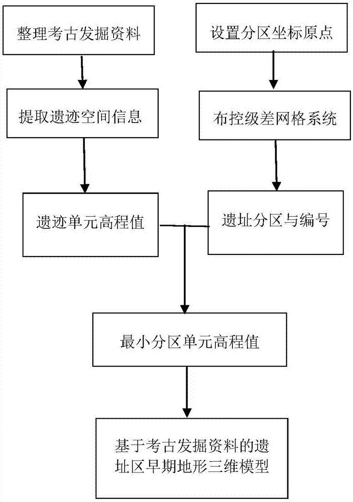
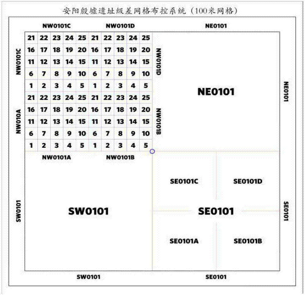
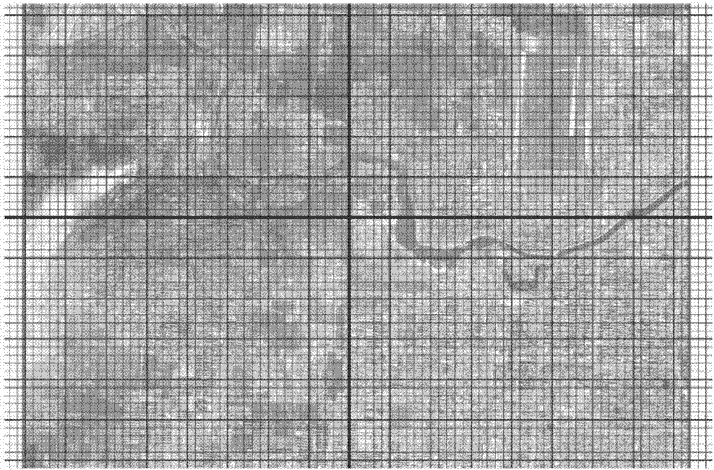
[0043] Yinxu is located around Xiaotun Village, Yindu District, Anyang City, Henan Province, with geographical coordinates at 114°18′50″E, 36°07′36″N. It is the capital ruins of the late Shang Dynasty. The core area of ​​the heritage protection area is 414 hectares, and the buffer area is 720 hectares. The overall layout of the Yin Ruins is rigorous, with the Yin Ruins palace and ancestral temple ruins in Xiaotun Village as the center, and they are distributed in a ring along the banks of the Huan River. The excavation of the Yin Ruins began in the 1920s, and the extant remains include the ruins of palaces and temples of Yin Ruins, the ruins of the royal tombs of Yin Ruins, the Huanbei Commercial City, the ruins of Hougang and settlements (clan towns), family cemeteries, oracle bone cellars, Copper casting ruins, handicraft workshops, etc. The scale of the Yinxu site in Anyang is large, and the excavation lasted for a long time. The classification, processing and analysis of ...


PUM


Abstract

The invention discloses an archaeological excavation data based relic site early terrain three-dimensional reconstruction method. The method includes steps: (1) partitioning a relic site, determiningminimum region units, numbering regions, and taking each minimum region unit as a basic recording unit; (2) subjecting the relic site to classifying space calibration, correcting relic space information sorted on the basis of excavation data into region cells, linking with the region units according to space positions, and performing statistics of depth of relics in the cells away from the groundsurface; (3) taking the ground surface close to excavation time as a starting surface to calculate depth of underground relic units by subtracting height, recorded in excavation data, of relics in certain time away from the ground surface from elevation of the starting surface; (4) taking center points of the minimum region units as elevation recording points and taking elevation values of relic units as elevation values of the minimum region units, using dispersed minimum region unit elevations to deduce ancient surface configuration in relic time, establishing a relic site early terrain three-dimensional model, and visualizing. The archaeological excavation data based relic site early terrain three-dimensional reconstruction method is scientific, effective, direct and accurate, is not only helpful to archaeological excavation data mining and using but also has a great promoting and assisting effect on archaeological site environment and layout research, thereby being significant to archaeological excavation data standardization, digitization, visualization and deep mining.

Description

technical field [0001] The invention belongs to the technical field of scientific and technological archaeology, and specifically relates to a new method for reconstructing the early topography of a site area by using archaeological excavation data and performing three-dimensional visualization. Background technique [0002] Archaeological excavation is an important method for archaeologists to understand human history, and it is the basis for relevant archaeological research work. Archaeological excavation data refer to the process records and important results of archaeological excavation. Scientific archaeological excavation data include written data, video data, graphic data and physical data. The first three are an overall record of physical data, and for some unpreservable relics, the first three are the embodiment of physical data and the core of archaeological excavation. Archaeological excavation is irreversible. Once the excavation work is completed, all informati...

Claims


Application Information

Patent Timeline
Patent Type & Authority Applications(China)
IPC IPC(8): G06F17/50G06T17/05G06T17/20
CPCG06T17/05G06T17/20G06F30/20Y02A90/10
Inventor 杨瑞霞陈盼盼唐际根
Owner INST OF REMOTE SENSING & DIGITAL EARTH CHINESE ACADEMY OF SCI
Why Eureka
Try Eureka