
Highway agglomerate fog early warning system and early warning method based on unmanned aerial vehicle and vehicle-highway cooperation

A technology of expressway, vehicle-road coordination, applied in the field of intelligent transportation, can solve the problems of inability to determine the temporal and spatial coverage of fog, not considering the temporal-spatial distribution characteristics of fog, etc., to reduce operational risks and improve operational efficiency.

Pending Publication Date: 2018-05-11
TIANJIN UNIV OF TECH & EDUCATION TEACHER DEV CENT OF CHINA VOCATIONAL TRAINING & GUIDANCE
View PDF9 Cites 21 Cited by
  • Summary
  • Abstract
  • Description
  • Claims
  • Application Information

AI Technical Summary

Problems solved by technology

There are some deficiencies in the above technical aspects: (1) It can only monitor the fog situation near the point where the detection equipment is located; (2) It can only monitor the severity of the fog (such as mist, medium fog, heavy fog), but cannot Determine the spatio-temporal coverage of the group fog; (3) After the group fog is detected, the traffic flow is often given an early warning through the display screen or the tweeter, without considering the time-spatial distribution characteristics of the group fog. Differentiated early warning for vehicles

Method used


Image

  • Highway agglomerate fog early warning system and early warning method based on unmanned aerial vehicle and vehicle-highway cooperation
  • Highway agglomerate fog early warning system and early warning method based on unmanned aerial vehicle and vehicle-highway cooperation
  • Highway agglomerate fog early warning system and early warning method based on unmanned aerial vehicle and vehicle-highway cooperation

Examples


Embodiment Construction

[0032] The present invention will be described in further detail below in conjunction with the accompanying drawings and specific embodiments. It should be understood that the specific embodiments described here are only used to explain the present invention, not to limit the present invention.

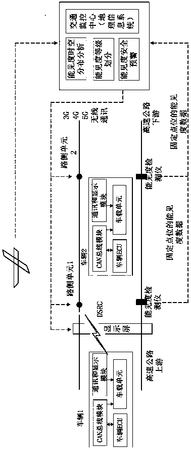
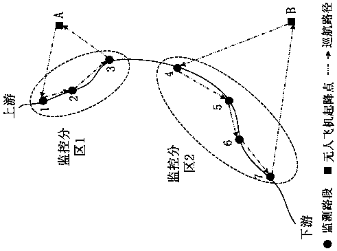
[0033] The highway cloud early warning system based on unmanned aircraft and vehicle-road coordination of the present invention includes an unmanned aerial vehicle monitoring system, a roadside monitoring system, a geographic information system and a forecasting system,

[0034] Described unmanned aerial vehicle monitoring system comprises unmanned aerial vehicle, the portable visibility detector and video camera that are fixedly arranged on the drone, and the airborne communication module in order to communicate with geographic information system; The technical parameter of portable visibility detector is : The measurement range is 10-10000m, and the data update frequency is 5-30 sec...


PUM


Abstract

The invention discloses a highway agglomerate fog early warning system and early warning method based on an unmanned aerial vehicle and vehicle-highway cooperation. The highway agglomerate fog early warning system comprises a UAV (unmanned aerial vehicle) monitoring system, a road side monitoring system, a geographical information system and a forecasting system. The UAV monitoring system comprises a UAV, a portable visibility meter and a video camera which are fixedly arranged on the UAV, and an airborne communication module communicated with the geographical information system. The road sidemonitoring system comprises a fixed visibility meter fixedly arranged at one side of the preset road section and in communication connection with the geographical information system. The forecastingsystem comprises a road side unit in communication connection with the geographical information system. The system realizes time-space monitoring of highway agglomerate fog in a large area based on the UAV and the vehicle-highway cooperation technology, and can carry out differential warning on individual vehicles in a separated road section and warning level manner, thereby greatly reducing operation risk under the highway agglomerate fog meteorological conditions and improving highway operation efficiency.

Description

technical field [0001] The invention relates to the technical field of intelligent transportation, in particular to an expressway fog early warning system and early warning method based on unmanned aircraft and vehicle-road coordination. Background technique [0002] Fog, as a natural phenomenon, has appeared on many highways in my country. Due to the appearance of fog, it will cause a sharp drop in driving visibility, which can easily lead to traffic accidents. The formation of cloud fog is closely related to the local microclimate environment. The daytime temperature of the expressway pavement is relatively high, and the temperature difference between day and night is large, which is conducive to the formation of fog. In addition, burning straw near the expressway in autumn will significantly increase pollutant particles, which may induce cloudy fog. The areas where rivers and reservoirs are located near expressways have high water vapor, which may also induce fog. In a...

Claims


Application Information

Patent Timeline
Patent Type & Authority Applications(China)
IPC IPC(8): G08G1/09G01W1/02G01W1/10
CPCG08G1/09G01W1/02G01W1/10
Inventor 关志伟刘晓锋宋裕庆肖金坚杜峰王龙志陈强高婷婷成英
Owner TIANJIN UNIV OF TECH & EDUCATION TEACHER DEV CENT OF CHINA VOCATIONAL TRAINING & GUIDANCE
Features
  • Generate Ideas
  • Intellectual Property
  • Life Sciences
  • Materials
  • Tech Scout
  • Unparalleled Data Quality
  • Higher Quality Content
  • 60% Fewer Hallucinations
Learn More