Immersive visual analysis method for spatio-temporal data on the basis of multilayer association network

A technology that correlates network, spatiotemporal data, applied in the field of geospatial information system to achieve the effect of promoting progress and development

Inactive Publication Date: 2018-05-18
SOUTHWEST JIAOTONG UNIV +1
View PDF3 Cites 17 Cited by
  • Summary
  • Abstract
  • Description
  • Claims
  • Application Information

AI Technical Summary

Problems solved by technology

[0005] Aiming at the problem that the aforementioned prior art is difficult to effectively analyze the potential and complex correlations in the multimodal spatio-temporal big data of human-machine-object ternary space fusion, the present invention provides a spatio-temporal data immersive visual analytics

Method used


Image

  • Immersive visual analysis method for spatio-temporal data on the basis of multilayer association network
  • Immersive visual analysis method for spatio-temporal data on the basis of multilayer association network
  • Immersive visual analysis method for spatio-temporal data on the basis of multilayer association network

Examples


Embodiment 1

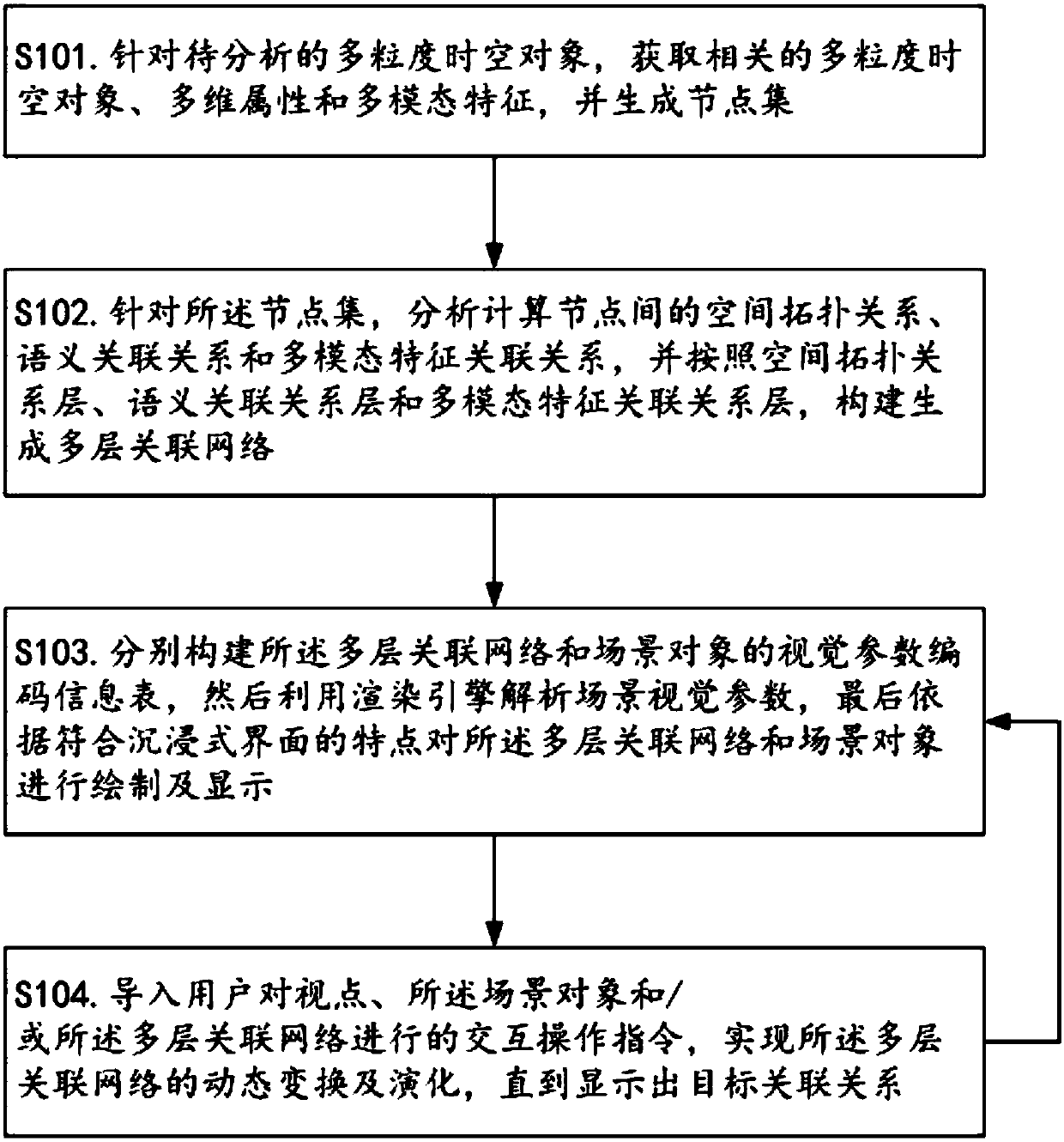
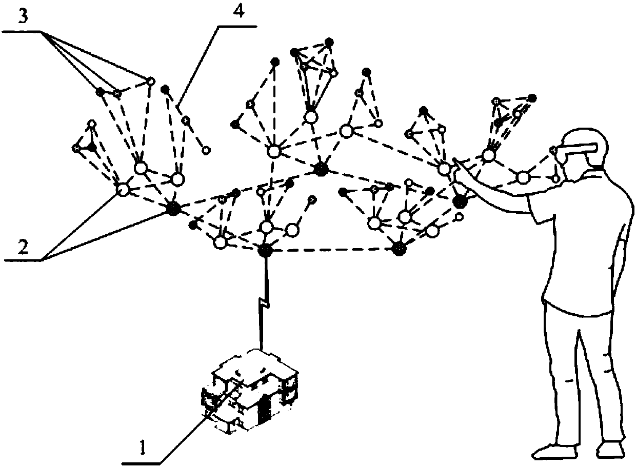
[0050] figure 1 It shows a schematic flowchart of the immersive visual analysis method for spatio-temporal data provided by the present invention, and Fig. 2 shows a schematic diagram of the immersive layout of the linkage between the multi-layer association network and scene objects provided by the present invention.

[0051] like figure 1 and 2 As shown, the method for immersive visual analysis of spatio-temporal data based on a multi-layer association network provided in this embodiment includes the following steps.

[0052] S101. For the multi-granularity spatio-temporal object to be analyzed, obtain related multi-granularity spatio-temporal objects, multi-dimensional attributes and multi-modal features, and generate a node set, wherein the multi-granularity spatio-temporal object to be analyzed is the user's analysis task The product of abstraction after understanding, the multimodal features are used to describe the properties of multi-granularity spatio-temporal objec...


PUM


Abstract

The invention relates to the technical field of geographic space information systems, and discloses an immersive visual analysis method for spatio-temporal data on the basis of a multilayer association network. The invention has the concept that: firstly, abstracting and extracting an object node related to a task from a scene; then, analyzing and calculating an association relationship among nodes, and carrying out hierarchical division on the association relationship among multi-granularity spatio-temporal objects; according to a spatial topological relationship, a semantic association relationship layer and a multi-modal characteristic association relationship layer, constructing a multilayer association network, and carrying out collaborative visual processing on the constructed multilayer association network and a scene; and finally, through a human-computer interaction operation, realizing a final purpose that inferential reasoning and discovery ability of a human brain can be combined and a potential and complex association relationship is assisted in discovery. Therefore, the method is favorable for people to quickly discover a new knowledge rule, and the progress and the development of human scientific knowledge are accelerated.

Description

technical field [0001] The invention relates to the technical field of geospatial information systems, in particular to an immersive visual analysis method for spatio-temporal data based on a multi-layer association network. Background technique [0002] With the rapid development of information and communication technologies such as sensor networks, the Internet of Things, and the Internet, the spatiotemporal data describing and recording the ternary space of human society (human), information space (machine), and physical world (thing) has increased rapidly. The visual analysis method is only for a single space, such as the spatial analysis method for geographical phenomena in the physical world, the social computing analysis method for human social social relations and group behavior phenomena, and the mining analysis method for computer network data in information space. Analytical model construction is difficult to effectively deal with multi-modal spatio-temporal data ...

Claims


Application Information

Patent Timeline
Patent Type & Authority Applications(China)
IPC IPC(8): G06F17/30
CPCG06F16/29G06F16/904
Inventor 付萧朱庆李赟杨卫军
Owner SOUTHWEST JIAOTONG UNIV
Why Eureka
Try Eureka