A Method of Target Area Filling and Fusion Processing Based on Satellite Remote Sensing Image

A satellite remote sensing image and target area technology, which is applied in the field of target area filling and fusion processing based on satellite remote sensing images, can solve problems such as restricting the development of the space information industry, disorder, and threats to the safety of national and people's lives and properties.

Active Publication Date: 2020-10-27
适普远景遥感信息技术(北京)有限公司
View PDF3 Cites 0 Cited by
  • Summary
  • Abstract
  • Description
  • Claims
  • Application Information

AI Technical Summary

Problems solved by technology

At present, most of the high-resolution remote sensing data used in the domestic civilian field come from foreign satellite data products. The high price and technical barriers have seriously restricted the development of the space information industry. support
The problem facing domestic remote sensing satellite data for civilian use is: the higher the resolution of the data and the more diverse the types, the more information people can obtain from it, and the more information that needs to be protected is also involved. Once the protected information If it is leaked, it will cause a major threat and immeasurable loss to the safety of the country and people's lives and properties. Therefore, camouflaging or hiding data in sensitive areas is an important prerequisite for civilian use of high-resolution remote sensing images.
[0004] After using the texture generation technology to process the target, the texture of the target is randomly generated by the surrounding texture, so the degree of refinement of the surrounding texture will seriously affect the texture quality of the filled area, and even the phenomenon of disorder will appear, making it impossible to distinguish the ground objects after filling , and this pixel-based calculation method has low processing efficiency and cannot meet the needs of high service timeliness

Method used


Image

  • A Method of Target Area Filling and Fusion Processing Based on Satellite Remote Sensing Image
  • A Method of Target Area Filling and Fusion Processing Based on Satellite Remote Sensing Image
  • A Method of Target Area Filling and Fusion Processing Based on Satellite Remote Sensing Image

Examples


Embodiment Construction

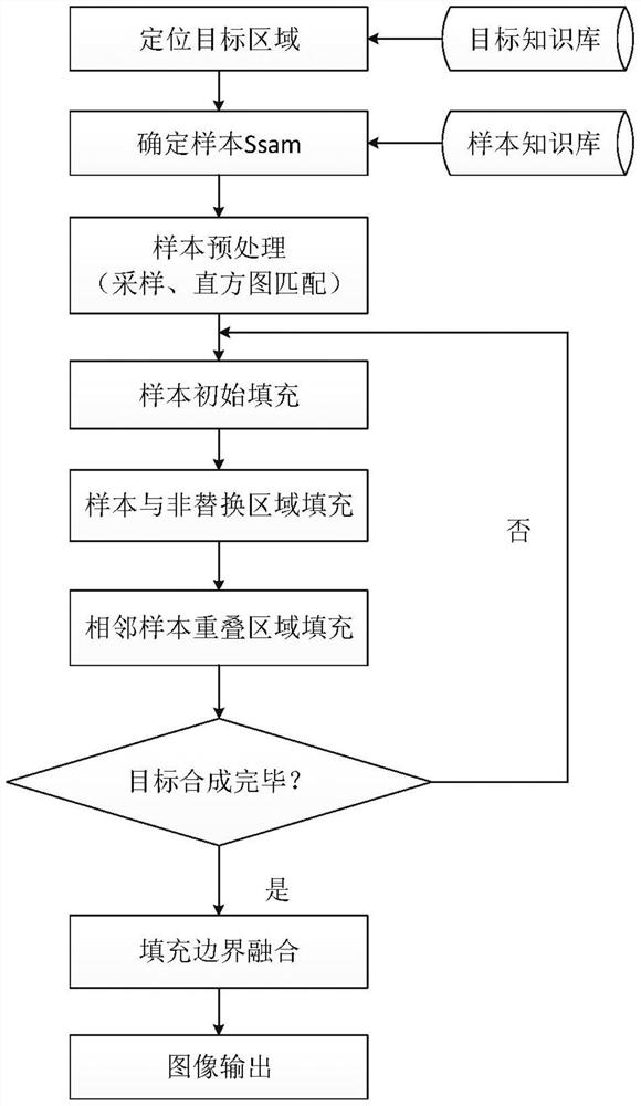
[0042] The present invention will be further described in detail below in conjunction with the accompanying drawings and specific embodiments.

[0043] figure 1 The specific implementation methods of the target area filling and fusion processing method based on satellite remote sensing images are as follows:

[0044] 1. Filling sample selection

[0045] Establish a database of filling samples for different seasons of visible light, infrared, multispectral, hyperspectral and SAR sensors. The types of filling samples include vegetation (grassland, woodland), buildings, cement ground, roads, mountains and rivers, etc. A sample for filling is selected from a sample database and the taken sample is recorded in the sample database. There are two methods for sample selection:

[0046] (1) For more typical targets, such as airport planes, wharf ships, etc., the corresponding relationship between the target and the replacement sample is established, and the replacement sample can be...


PUM


Abstract

The invention discloses an object area filling and fusion processing method based on satellite remote sensing images; the method comprises the following steps: 1, building a sample database; 2, preprocessing samples; 3, filling samples in a replacement area; 4, fusing boundary; 5, outputting the image with the filled samples and fused boundary in an original object image format, and writing responding satellite parameter information. The method hides texture samples with certain features and forms into a specific area, thus solving the problems that formed object area textures cannot have certain natural object characteristics and the textures are tedious and orderlies under surrounding complex environments; the method is based on an area replacement method, is fast in a processing speed when compared with a forming method based on pixel points, thus satisfying chronergy problems.

Description

technical field [0001] The invention relates to the field of remote sensing image processing, in particular to a target area filling and fusion processing method based on satellite remote sensing images. Background technique [0002] With the development of remote sensing technology, the demand for high-resolution remote sensing data in various fields of the national economy is becoming more and more extensive. Government decision-making needs to use high-resolution remote sensing data for resource investigation, disaster relief, and command decision-making. Remote sensing image data has become an important data support for services in land, water conservancy, urban planning, agriculture, environmental protection, and transportation. At present, most of the high-resolution remote sensing data used in the domestic civilian field come from foreign satellite data products. The high price and technical barriers have seriously restricted the development of the space information i...

Claims


Application Information

Patent Timeline
Patent Type & Authority Patents(China)
IPC IPC(8): G06T5/00G06T5/40G06T7/11
CPCG06T5/001G06T5/40G06T2207/10032G06T2207/20021G06T2207/30181G06T7/11
Inventor 杨晓冬王楠梁斯东
Owner 适普远景遥感信息技术(北京)有限公司
Why Eureka
Try Eureka