Port ore stockyard identification method based on remote sensing screen classification

A technology of scene classification and recognition method, which is applied in scene recognition, character and pattern recognition, instruments, etc. It can solve the problems of unrecognizable, lack of pertinence, and no shape of ore stockyard, so as to improve accuracy, reduce data volume, and avoid Check the effect

Active Publication Date: 2018-06-05
TRANSPORT PLANNING & RES INST MINIST OF TRANSPORT
View PDF6 Cites 11 Cited by
  • Summary
  • Abstract
  • Description
  • Claims
  • Application Information

AI Technical Summary

Problems solved by technology

[0006] (1) First of all, there is currently no special method for remote sensing identification of logistics warehouses behind the port. The existing methods are suitable for the identification of other ground objects, so they cannot be accurately identified according to the characteristics of port warehouses. In the process of remote sensing big data processing, due to the lack of pertinence, the data processing efficiency is low;
[0007] (2) Secondly, most of the existing data processing methods are based on the direct extraction of remote sensing images, and the main defect of this extraction method is that the amount of original data processing is relatively large. In this calculation process, often the Some data that is unnecessary or not in this category will also be taken into account, further enhancing the complexity of data processing;
[0008] (3) Furthermore, in the existing data processing process, in the existing data processing, there is no image classification based on the characteristics of the ore stockyard to extract features, so the image extraction is not accurate, and because the ore stockpile The field has no specific shape. In the actual identification, it needs to be continuously corrected and corrected according to the scene in order to be accurately identified. This defect is not involved in most current technical solutions.

Method used


Image

  • Port ore stockyard identification method based on remote sensing screen classification
  • Port ore stockyard identification method based on remote sensing screen classification
  • Port ore stockyard identification method based on remote sensing screen classification

Examples


Embodiment

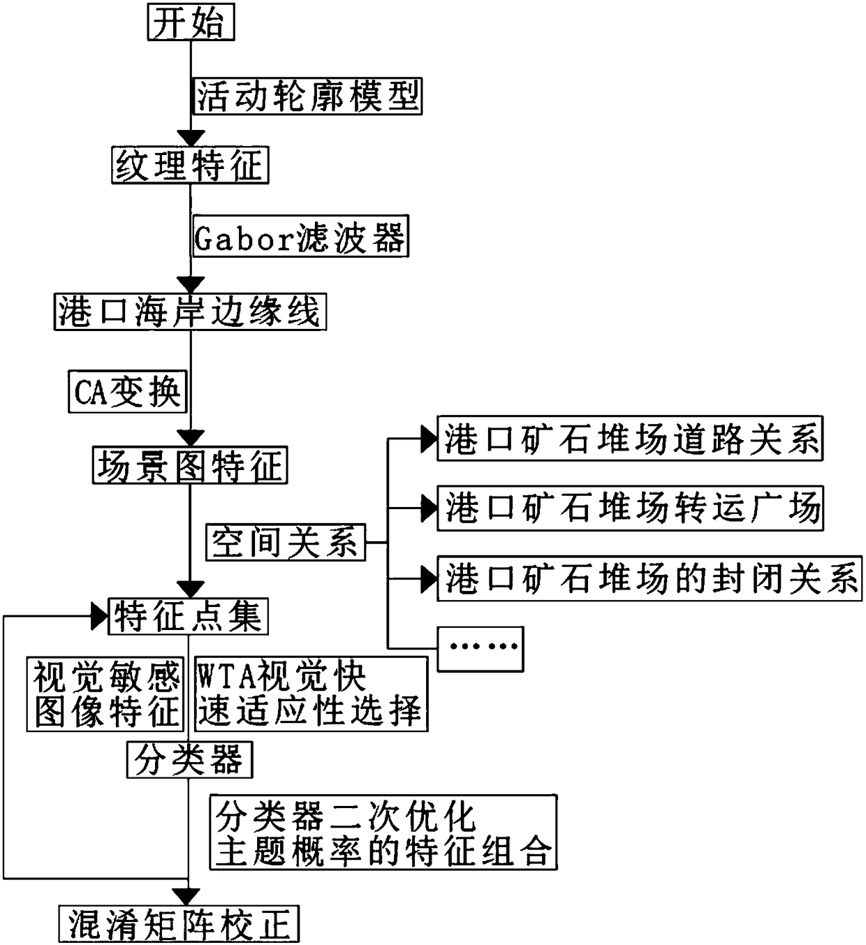
[0041] Such as Figure 1 to Figure 3 As shown, the present invention provides a method for identifying port ore yards based on remote sensing scene classification, comprising the following steps:

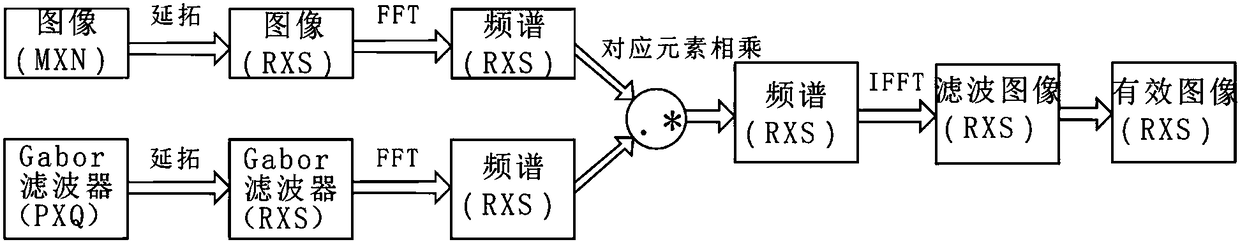
[0042] S100. Extracting the coastline of the port based on the active contour model, sequentially performing texture feature recognition on any region of the remote sensing image, forming sea texture regions and irregular texture regions, and extracting port coastlines through a filter algorithm.

[0043] In the above steps, the texture feature recognition adopts the gray level co-occurrence matrix method, and the specific steps of the recognition are as follows:

[0044] S101, arbitrarily selecting an area of ​​the remote sensing image, and setting the area to have L gray values, then the gray co-occurrence matrix corresponding to the area is a matrix of LXL order;

[0045] S102. Select any position (i, j) in the matrix, where (i, j=1, 2, ..., L), then the position element at this...


PUM


Abstract

The invention discloses a port ore stockyard identification method based on remote sensing screen classification. The method comprises the following steps of firstly, performing texture characteristicidentification on a random area of a remote sensing image, and extracting a port coast edge line; secondly, performing classification based on CA change through different scene picture characteristicdifferences; based on accurate identification to an ore stockyard spatial relation characteristic, extracting an association relation of the ore stockyard, and forming a characteristic point set by the identified to-be-analyzed ore stockyard; finally, establishing a classifier through regular logic regression, and performing secondary optimization through a classifier for obtaining a constrainedcondition; combining a theme probability characteristic and performing scene classification by means of a vector classifier for identifying the ore stockyard; extracting an original attribute througha texture characteristic, eliminating impurity data, and obtaining a scene picture characteristic after layering capability obtainment through CA conversion. The port ore stockyard identification method has relatively high pertinence and can calibrate data in real time, thereby performing data updating identification according to a field condition and realizing high accuracy.

Description

technical field [0001] The invention relates to the technical field, in particular to a port ore stockyard identification method based on remote sensing scene classification. Background technique [0002] Remote sensing images are widely used in various aspects, and with the further development of remote sensing image recognition technology, its application will be further improved. In the application of remote sensing, information can be collected without direct contact with relevant targets, and can be interpreted, classified and identified. The use of remote sensing technology can dynamically, quickly and accurately obtain a large amount of earth observation data. [0003] As the hub of sea transportation, port plays a very important role, so it has been paid more and more attention by people, and it has become an important research direction for planning sea transportation. In the construction and planning of the port, it is first necessary to collect port data, that is...

Claims


Application Information

Patent Timeline
Patent Type & Authority Applications(China)
IPC IPC(8): G06K9/00G06K9/46G06K9/62
CPCG06V20/13G06V10/443G06F18/241
Inventor 董敏齐越聂向军丁文涛陈飞童剑强
Owner TRANSPORT PLANNING & RES INST MINIST OF TRANSPORT
Why Eureka
Try Eureka