UAV operator positioning system and method based on aerial radio monitoring platform

A technology for radio monitoring and aircraft operators, applied in radio wave direction/deviation determination systems, direction finders using radio waves, etc., can solve problems affecting positioning accuracy, poor emergency maneuverability, large volume, etc., to achieve the elimination of positioning The influence of accuracy, overcoming the dependence of the environment, and the effect of high-precision spatial positioning

Active Publication Date: 2022-01-28
国家无线电监测中心
View PDF7 Cites 0 Cited by
  • Summary
  • Abstract
  • Description
  • Claims
  • Application Information

AI Technical Summary

Problems solved by technology

[0007] (1) In a complex urban environment, obstacles will cause multipath and non-line-of-sight conditions during the propagation of the remote control signal, which will greatly reduce the measurement accuracy of parameters such as TDOA or AOA, and seriously restrict the positioning of existing ground monitoring equipment. ability;
[0008] (2) The positioning technology based on ground monitoring equipment is currently mainly used for monitoring and positioning of frequently sent signals. The ability to accurately capture and measure parameters for the fast frequency-hopping signals emitted by the remote control of the UAV is limited, which seriously affects the positioning accuracy.
[0009] (3) The ground monitoring and positioning system needs to be erected at multiple points, and the position is relatively fixed. It cannot flexibly complete the positioning task of the emission source in different areas, and the emergency maneuverability is poor.
[0010] (4) The ground monitoring and positioning system is large in size, complex in structure and high in economic cost

Method used


Image

  • UAV operator positioning system and method based on aerial radio monitoring platform
  • UAV operator positioning system and method based on aerial radio monitoring platform
  • UAV operator positioning system and method based on aerial radio monitoring platform

Examples


Embodiment Construction

[0037] The specific embodiments of the present invention will be described in detail below in conjunction with the technical solutions and accompanying drawings.

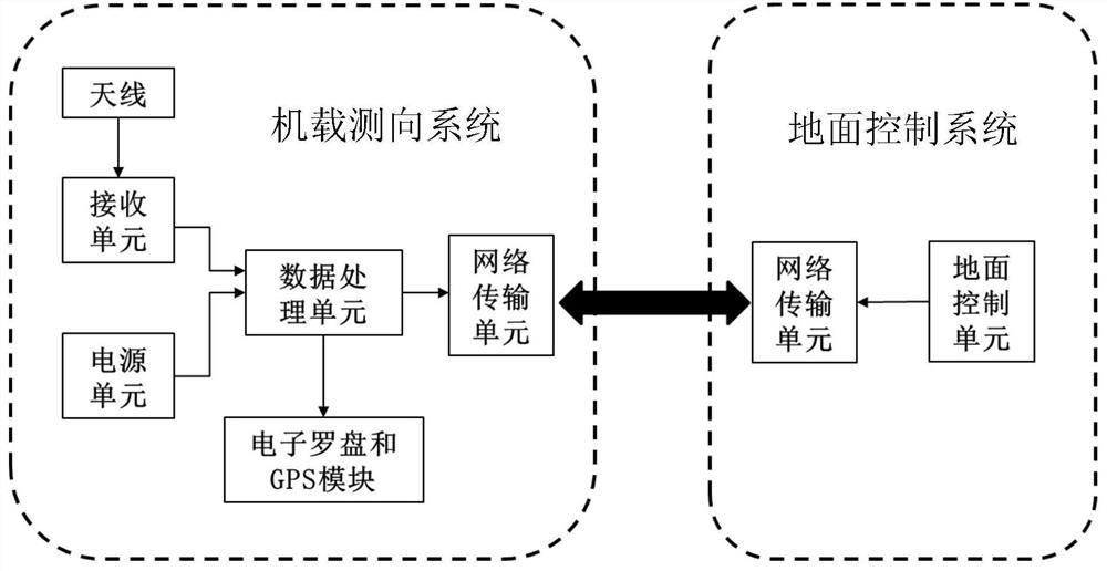
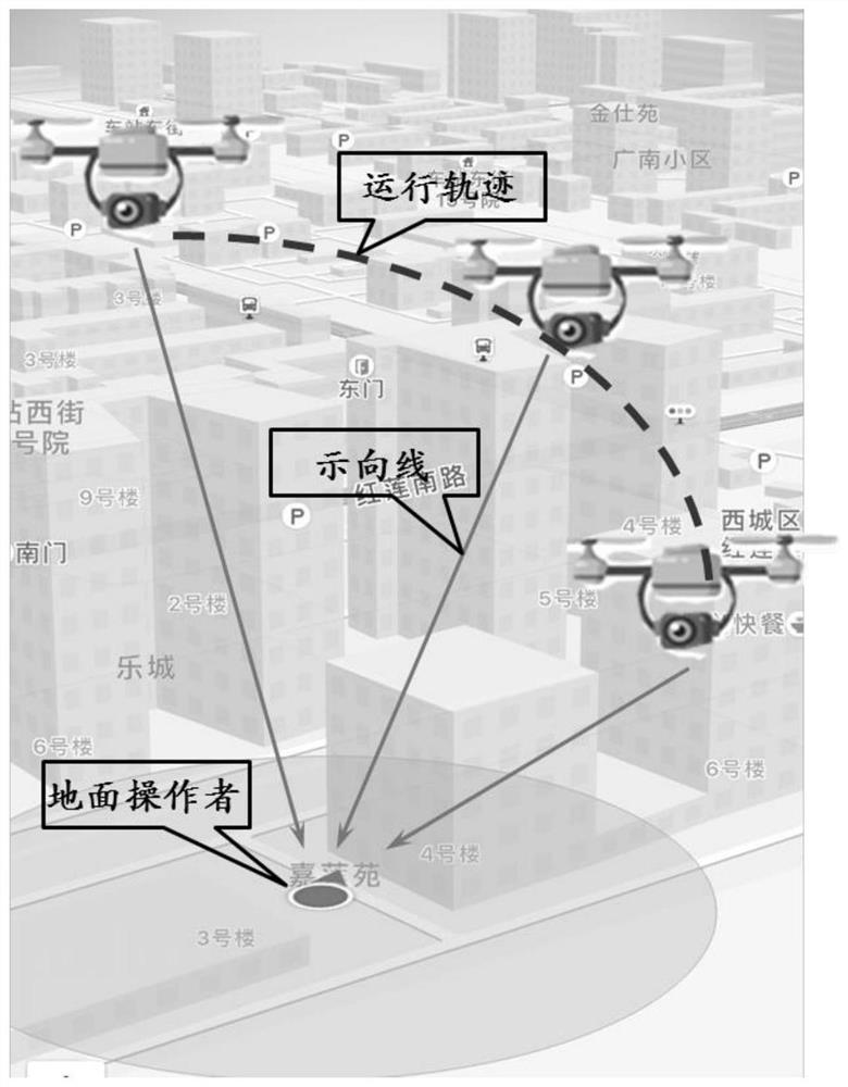
[0038] The UAV ground operator positioning system based on the aerial radio monitoring platform proposed by the present invention is used to solve the practical problem of operator positioning under the new situation of UAV control, and is a brand-new monitoring and positioning means. The invention can play an important and positive role in improving the control capability of the drone, maintaining people's property safety and social stability. The core technology of the invention is to realize rapid discovery and precise positioning of frequency hopping signals under complex background noise. The system has simple structure, high integration, small size, light weight, and strong mobility. It can respond quickly to emergencies and greatly reduce construction costs, which has great practical significance.

[0039] T...


PUM


Abstract

The invention discloses a drone operator positioning system and method based on an aerial radio monitoring platform, and belongs to the technical field of radio direction finding and positioning. The invention includes an airborne direction finding system and a ground control system. The airborne direction finding system measures the incoming wave direction where the maximum energy of the target signal appears, and determines the position; the ground control system remotely controls the airborne direction finding system and the air monitoring platform, and obtains the positioning in real time. result. The airborne direction finding system collects and compresses the target signal, extracts the frequency hopping signal, and matches the azimuth angle, GPS position and time information with the frequency hopping signal in real time; the ground control system controls the air monitoring platform to change the air attitude, so that the airborne measurement Determine to the system the incoming wave direction where the maximum energy of the target signal appears. The present invention is applicable to areas where multi-point ground monitoring equipment is unconditionally erected in complex urban environments, saves manpower and funds, and realizes wide-band, all-round, and high-precision spatial positioning of frequency-hopping signals of remote controllers.

Description

technical field [0001] The invention belongs to the technical field of radio direction finding and positioning, and relates to a positioning method for a drone operator, in particular to a ground remote control frequency hopping signal positioning system and method for a drone based on an aerial radio monitoring platform. Background technique [0002] With the maturity of drone technology and the vigorous development of consumer drones, the extensive use of drones has also brought some safety hazards, especially the "black flight" incidents have been repeatedly banned, which not only seriously disrupted air traffic order, but also endangered aviation. Safety also poses a security threat to the lives and property of the people. It can be said that drone control is imperative. As the national radio management department, it is necessary to effectively supervise the "black flight" of UAVs in terms of radio security. It is necessary to quickly discover and identify "unknown" UAV...

Claims


Application Information

Patent Timeline
Patent Type & Authority Patents(China)
IPC IPC(8): G01S3/14
CPCG01S3/14
Inventor 夏楠鲍尧王文帅汪庭霁胡中雨冀维林段洪涛李景春
Owner 国家无线电监测中心
Why Eureka
Try Eureka