Laser-point cloud and image fusion data classification method based on multi-characteristic

A laser point cloud and data classification technology, applied in the field of data classification, can solve problems such as being easily affected by time, climate and weather, difficult to meet the needs of practical applications, and air quality degradation, so as to reduce misclassification and reduce complexity. , the effect of improving stability

Inactive Publication Date: 2018-07-03
NORTH CHINA UNIV OF WATER RESOURCES & ELECTRIC POWER
View PDF5 Cites 17 Cited by
  • Summary
  • Abstract
  • Description
  • Claims
  • Application Information

AI Technical Summary

Problems solved by technology

[0002] The data source of traditional ground object classification mainly comes from remote sensing images of aerospace photography, which are classified according to the spectrum, texture and other characteristi

Method used


Image

  • Laser-point cloud and image fusion data classification method based on multi-characteristic
  • Laser-point cloud and image fusion data classification method based on multi-characteristic

Examples


Embodiment Construction

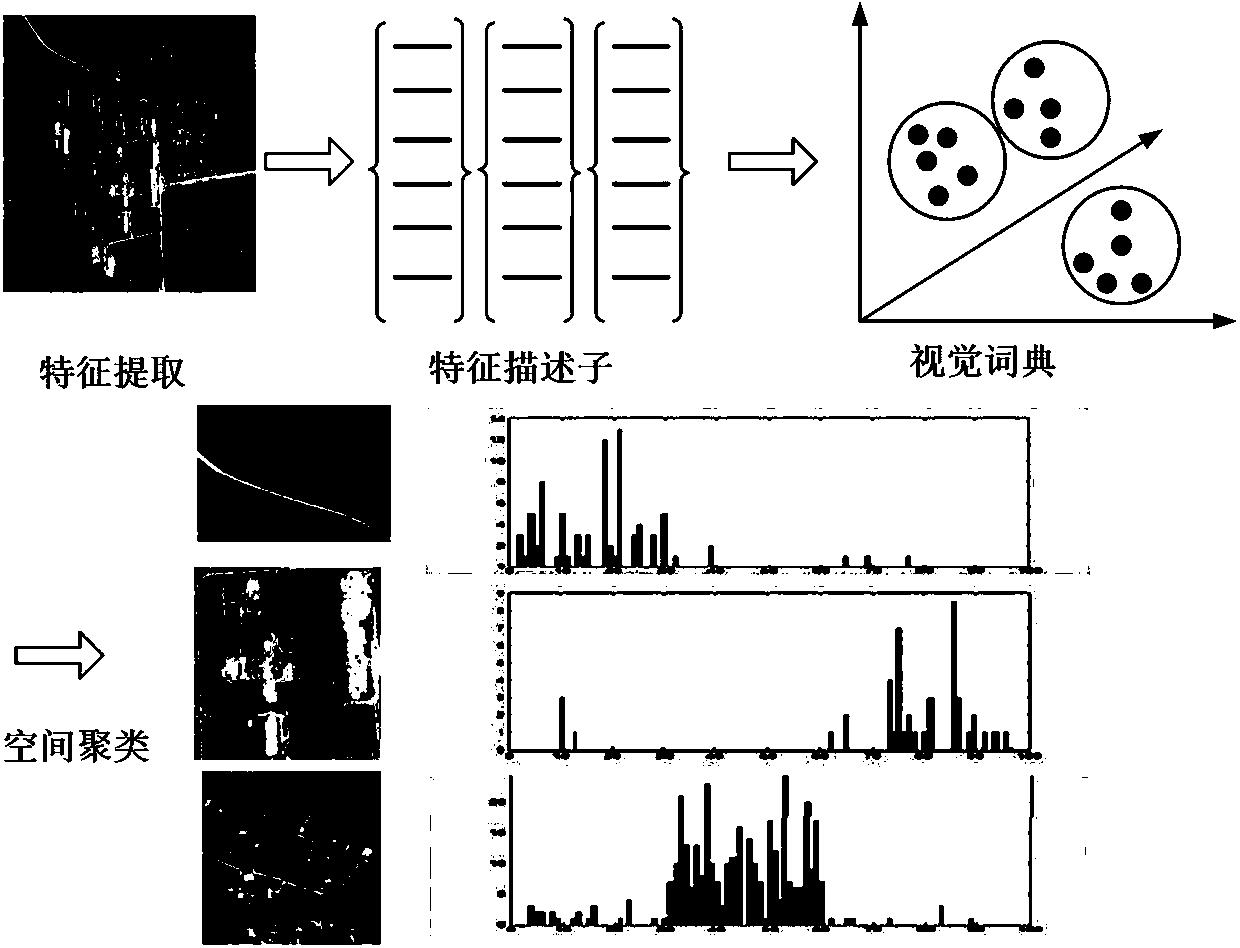
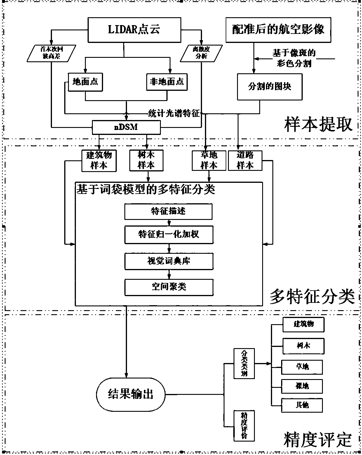
[0035] Due to the complexity and diversity of ground features, existing technologies simply use point cloud data for accurate ground feature classification and recognition, and there are very difficult problems. To solve the above problems, point cloud The classification results can improve the accuracy of LiDAR point cloud classification alone. Therefore, the present invention still proceeds from the data obtained by two different sensors of laser point cloud and aerial image, and proposes a multi-feature-based classification method for laser point cloud and image fusion data. This method mainly involves three parts, namely multi-source data fusion feature description module, point cloud classifier design module based on multi-features and classification accuracy analysis module. Its purpose is to use the classification strategy of integrating multi-source data to set corresponding classification rules for the main objects of classification, and then establish the correspondi...


PUM


Abstract

A laser-point cloud and image fusion data classification method based on multi-characteristic comprises the following steps: 1, data preprocessing: preprocessing aviation image and unmanned plane laser-point cloud data; 2, sample extraction: fully utilizing geometry characteristics of the point cloud data and spectrum characteristics of the aviation images so as to carry out sample extraction of various types; 3, fusion data classification based on multi-characteristic: using a vector description model to classify the sample data; 4, precision evaluation: evaluating the precision of the classified data. The method is complete in surface object extraction and high in classification precision. The method starts from the angle of the fusion image spectrum information, carries out data fusionaccording to application purposes and surface object classification demands, sets corresponding classification rules for classification of main surface objects, and builds a corresponding relation between classification types and classification characteristics, thus extracting complete surface object areas, and reducing misclassification phenomenon.

Description

technical field [0001] The invention relates to a data classification method, in particular to a multi-feature-based laser point cloud and image fusion data classification method. Background technique [0002] The data source of traditional ground object classification mainly comes from remote sensing images of aerospace photography, which are classified according to the spectrum, texture and other characteristics of the image, but it is easily affected by time, climate and weather, especially in recent years, the serious decline in air quality in my country has made it difficult meet the needs of practical applications. LiDAR technology (Light Detection And Ranging, LiDAR), as a new type of active remote sensing technology, can quickly, accurately and timely obtain remote sensing data on the earth's surface, making it useful in emergency response to major natural disasters, low-altitude large-scale high-precision measurement In the case of map, urban planning or 3D model re...

Claims


Application Information

Patent Timeline
IPC IPC(8): G06K9/62G06K9/46G06K9/03G06K9/00
CPCG06V20/13G06V10/993G06V10/464G06F18/23213G06F18/251G06F18/24
Inventor 何培培翟燕马开锋黄桂平
Owner NORTH CHINA UNIV OF WATER RESOURCES & ELECTRIC POWER
Why Eureka
Try Eureka