An efficient gradient coloring method for 3D terrain based on WPF
A 3D terrain and efficient technology, applied in 3D image processing, instruments, calculations, etc., can solve the problems of low rendering efficiency and large resource consumption, and achieve the effect of saving system resources, simple processing method, and improving 3D rendering efficiency
- Summary
- Abstract
- Description
- Claims
- Application Information
AI Technical Summary
Problems solved by technology
Method used
Image
Examples
Embodiment
[0041] Embodiment: In order to verify the feasibility and effectiveness of this application, this embodiment takes the gradient coloring of a three-dimensional terrain model of a real river network in Panyu District, Guangzhou City as a specific implementation case to further illustrate the present invention.
[0042] The selected river network example for 3D terrain modeling is located in Panyu District, Guangzhou City, at 22°52'37.1"~22°57'15" north latitude, 113°15'41"~113°29'47" east longitude, A section of river network composed of Zini River waterway, Longwan River, Shiqiao waterway and Shawan waterway.
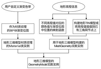
[0043] Step 1: Generate a gradient bitmap with a size of 64*64 in memory according to the color level of the custom gradient ribbon, and use it as the image source (ImageSource) of the image brush (ImageBrush).
[0044] The RGB value of the custom color band level is as follows:
[0045] Color level 1: R=0, G=0, B=255;
[0046] Color level 2: R=0, G=64, B=255;
[004...
PUM
 Abstract
Description
Claims
Application Information
 - R&D
- Intellectual Property
- Life Sciences
- Materials
- Tech Scout
- Unparalleled Data Quality
- Higher Quality Content
- 60% Fewer Hallucinations
Browse by: Latest US Patents, China's latest patents, Technical Efficacy Thesaurus, Application Domain, Technology Topic, Popular Technical Reports.
© 2025 PatSnap. All rights reserved.Legal|Privacy policy|Modern Slavery Act Transparency Statement|Sitemap|About US| Contact US: help@patsnap.com


