Integrated navigation information fusion method

A technology of integrated navigation and fusion method, applied in the field of integrated navigation information fusion, which can solve the problems of rough measurement noise statistics, divergence of filtering precision Kalman filtering, and inability to deal with complex electromagnetic environments in time

Active Publication Date: 2018-07-31
PEKING UNIV
View PDF8 Cites 9 Cited by
  • Summary
  • Abstract
  • Description
  • Claims
  • Application Information

AI Technical Summary

Problems solved by technology

[0003] In view of the fact that the measurement noise statistics in the traditional integrated navigation system are rough and cannot cope with the complex electromagnetic environment or the drastic changes of the mobile carrier in time, the present invention pro

Method used


Image

  • Integrated navigation information fusion method
  • Integrated navigation information fusion method
  • Integrated navigation information fusion method

Examples


Embodiment Construction

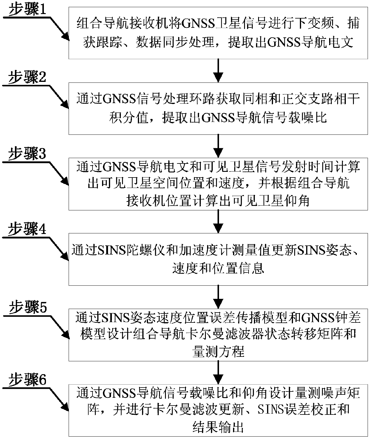
[0071] In order to make the object, technical solution and advantages of the present invention clearer, the present invention will be further described in detail below in combination with specific embodiments and with reference to the accompanying drawings. It should be understood that these descriptions are exemplary only, and are not intended to limit the scope of the present invention. Also, in the following description, descriptions of well-known structures and techniques are omitted to avoid unnecessarily obscuring the concept of the present invention.

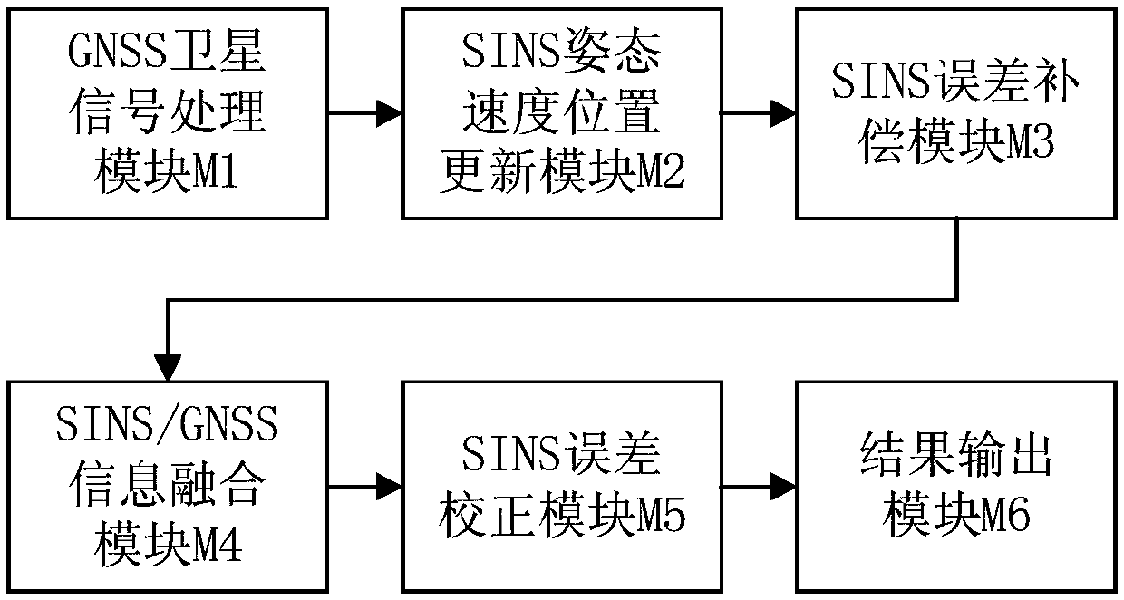
[0072] figure 1 A schematic diagram of a combined navigation information fusion module in a preferred embodiment of the present invention is shown.

[0073] Such as figure 1 As shown, the combined navigation information fusion of the preferred embodiment of the present invention mainly includes the GNSS satellite signal processing module M1, the SINS attitude velocity position update module M2, the SINS error compensati...


PUM


Abstract

The invention discloses an integrated navigation information fusion method. The method is mainly divided into a GNSS satellite signal processing module, a SINS attitude, velocity and position updatingmodule, a SINS error compensation module, a SINS/GNSS information fusion module, a SINS error correction module and a result output module. According to the method, by means of high-frequency SINS attitude, velocity and position updating and low-frequency GNSS information measurement, the elevation angle and navigation information carrier-to-noise ratio of all visible satellites tracked by an integrated navigation receiver are combined, a SINS/GNSS integrated navigation Kalman filter observation noise matrix is adaptively adjusted in real time, by means of GNSS and SINS pseudorange and a pseudorange rate measuring value, an integrated navigation Kalman filter state equation and an error covariance matrix are updated, and finally by means of SINS and GNSS information infusion feedback, aninertial device measuring error is corrected. According to the integrated navigation information fusion method, the purpose that under the complex electromagnetic environment, the integrated navigation receiver completes robust information fusion resolving can be achieved, and the method has high integrated navigation receiver design theory value and engineering application value.

Description

technical field [0001] The invention belongs to the technical field of satellite navigation, and in particular relates to a combined navigation information fusion method, which can effectively improve the positioning accuracy of strapdown inertial navigation and satellite navigation receivers. Background technique [0002] Global Navigation Satellite System (GNSS) can provide positioning, navigation and timing services for receivers, and plays an extremely important role in various industries. At present, the global satellite navigation system mainly includes GPS of the United States, BDS of China, GALILEO of Europe and GLONASS of Russia. The signal processing terminal of the navigation receiver extracts the GNSS navigation message and calculates according to the Interface Control Document (ICD) of each navigation system. Satellite space position and velocity, and then realize the receiver positioning solution. Inertial Navigation System (INS) is an autonomous dead reckonin...

Claims


Application Information

Patent Timeline
IPC IPC(8): G01C21/20G01C21/16G01S19/33G01S19/47
CPCG01C21/165G01C21/20G01S19/33G01S19/47
Inventor 朱柏承孟凡琛牛尊
Owner PEKING UNIV
Why Eureka
Try Eureka