Method for remote sensing quantitative assessment of yield loss of rapeseed under waterlogging damage stress based on satellite data

A satellite data and quantitative evaluation technology, applied in the interpretation of photos, etc., can solve the problems of yield loss caused by wet stains, increase the acquisition of satellites with high spatial resolution, and achieve the effect of improving model accuracy and ensuring availability.

Active Publication Date: 2018-08-03
ZHEJIANG UNIV
View PDF3 Cites 8 Cited by
  • Summary
  • Abstract
  • Description
  • Claims
  • Application Information

AI Technical Summary

Problems solved by technology

[0019] The launch of these high-spatial-resolution satellites has increased the possibility of obtaining high-spatial-resolution satellites, but so far, the application of these

Method used


Image

  • Method for remote sensing quantitative assessment of yield loss of rapeseed under waterlogging damage stress based on satellite data
  • Method for remote sensing quantitative assessment of yield loss of rapeseed under waterlogging damage stress based on satellite data
  • Method for remote sensing quantitative assessment of yield loss of rapeseed under waterlogging damage stress based on satellite data

Examples


Embodiment Construction

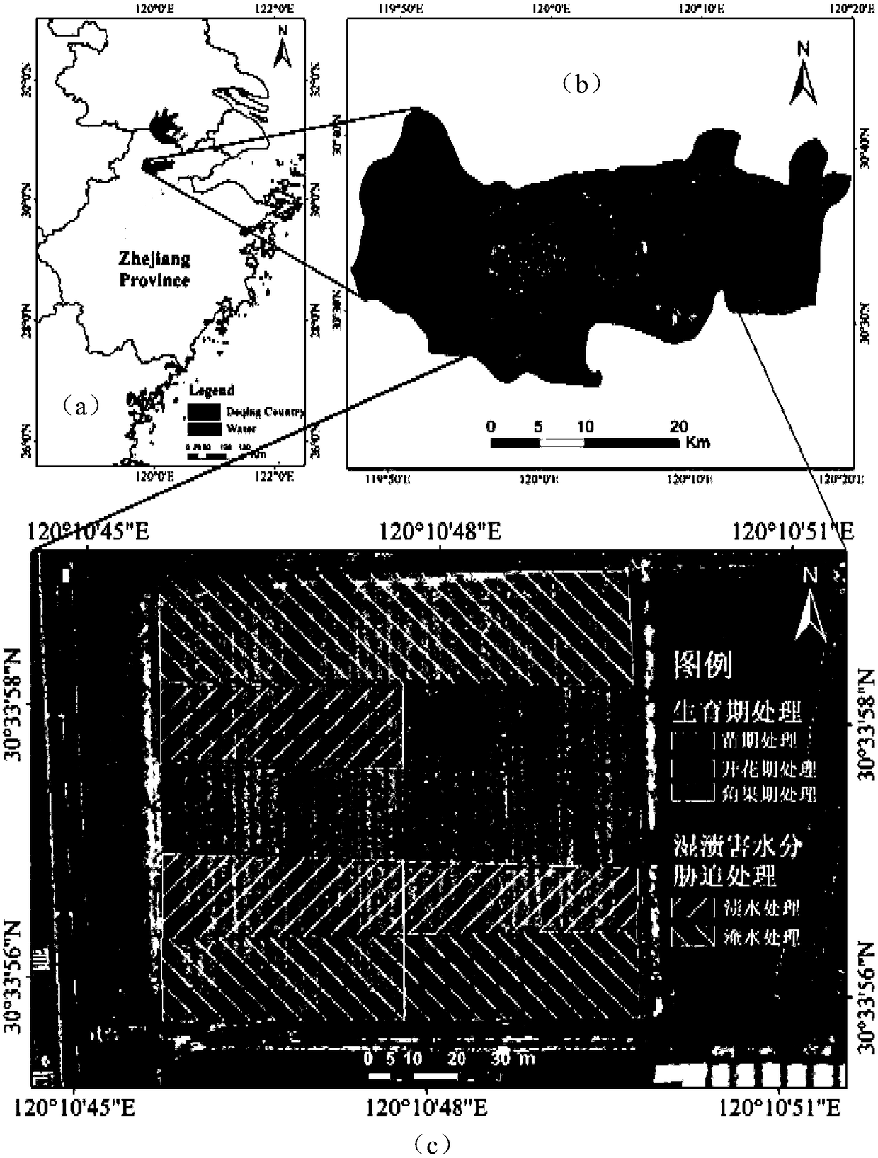
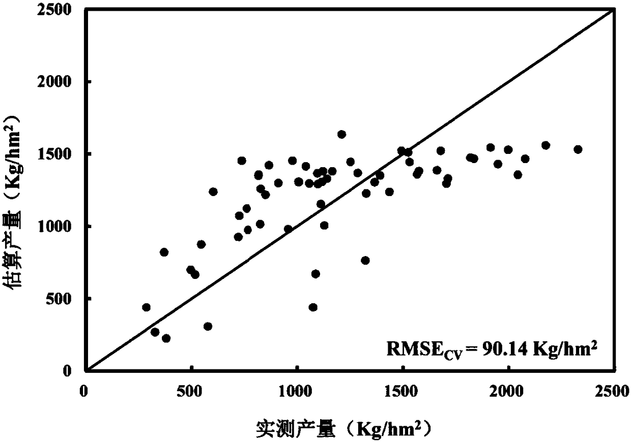
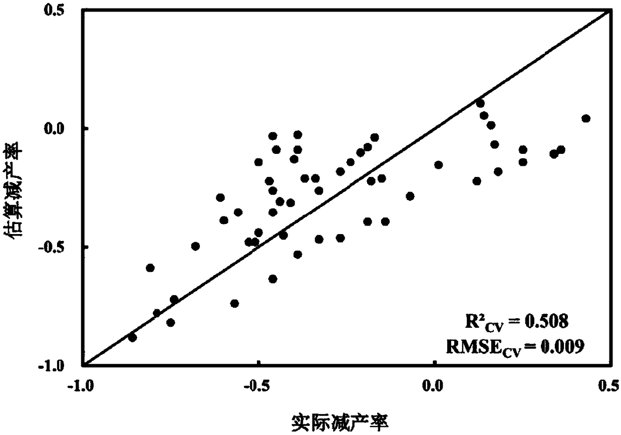
[0047] The present invention will be further described below in conjunction with specific drawings and implementation examples. The present invention is a method for remote sensing quantitative evaluation of rapeseed yield loss at the block scale under waterlogging stress, and the specific calculation method includes the following steps:

[0048] Step 1: Carry out a plot-scale rapeseed wet-soiling field test, including: normal rapeseed plots and rapeseed-planted plots under wet-spotting stress, and wet-spotting stress at different developmental stages of rapeseed;

[0049] Step 2: Obtain satellite remote sensing data with high spatial resolution in different time phases, and perform preprocessing to resample satellite image data with different spatial resolutions to obtain satellite image data with the same spatial resolution;

[0050] Preprocessing specifically includes radiometric calibration, geometric correction, and atmospheric correction. After obtaining high-spatial-res...


PUM


Abstract

The invention discloses a method for the remote sensing quantitative assessment of the yield loss of rapeseed under a waterlogging damage stress based on satellite data. The method comprises the following steps: carrying out plot-scale rapeseed waterlogging damage field trials to obtain ground rapeseed yield data of different varieties in different development stages under different waterlogging damage treatments; obtaining and preprocessing satellite image data with a high spatial resolution; calculating the rape waterlogging damage induced yield loss rate and the vegetation index change rateunder the waterlogging damage stress; analyzing the correlation coefficient of the rapeseed yield and the yield reduction rate to the vegetation index and the vegetation index change rate under the waterlogging damage stress; and establishing a model for the remote sensing quantitative estimation of the plot-scale rapeseed yield reduction under the waterlogging damage stress by using a multiple regression technology, and performing accuracy test. The method can be used to provide services for the accurate management of water and fertilizers in farmers' rapeseed fields and provide a basis forthe insurance company to develop disaster loss evaluation and loss assessment.

Description

technical field [0001] The invention relates to the technical field of optical remote sensing data processing, in particular to a remote sensing quantitative evaluation method for rapeseed yield loss under waterlogging stress based on satellite data. Background technique [0002] For a long time, due to the characteristics of high-spatial-resolution satellites, such as strong ability to distinguish different ground objects, high spatial resolution, and accurate information, the technology and application of high-resolution remote sensing satellites are related to national security and are highly classified by the state. It is used to obtain the enemy's economic status, military intelligence, spatial geographic data, etc. It was not until 1999 that the United States successfully launched the first commercial high-resolution remote sensing satellite Ikonos, which opened a new era of high spatial resolution satellites (Jin Fei, 2013). The huge military advantages and economic ...

Claims


Application Information

Patent Timeline
IPC IPC(8): G01C11/04
CPCG01C11/04
Inventor 黄敬峰韩佳慧
Owner ZHEJIANG UNIV
Why Eureka
Try Eureka