Urban vegetation classification method based on unmanned aerial vehicle images and reconstructed point cloud

A classification method, UAV technology, applied in computer parts, instruments, characters and pattern recognition, etc., can solve problems such as inability to extract different types of vegetation

Active Publication Date: 2018-08-03
HENAN POLYTECHNIC UNIV
View PDF6 Cites 31 Cited by
  • Summary
  • Abstract
  • Description
  • Claims
  • Application Information

AI Technical Summary

Problems solved by technology

In the past, the characteristics of image spectrum, texture and shape were mostly used in the classification of urban vegetation, and a certain type of vegetation could be extracted well, but it was not possible to further extract different types of vegetation from the large category of vegetation based on height information.

Method used


Image

  • Urban vegetation classification method based on unmanned aerial vehicle images and reconstructed point cloud
  • Urban vegetation classification method based on unmanned aerial vehicle images and reconstructed point cloud
  • Urban vegetation classification method based on unmanned aerial vehicle images and reconstructed point cloud

Examples


Embodiment Construction

[0047] The technical solutions of the present invention will be described in further detail below through specific implementation methods.

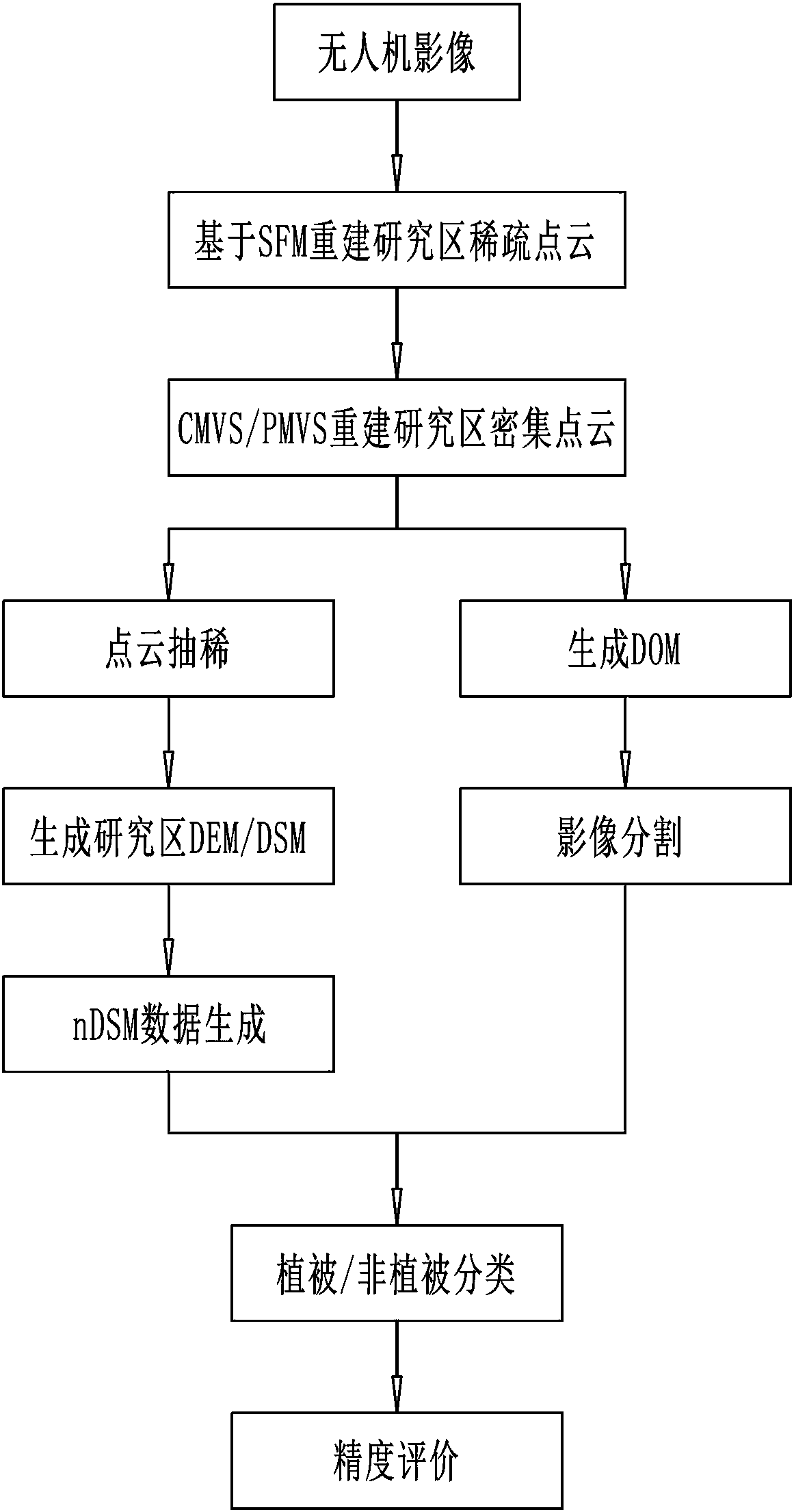
[0048] Such as figure 1 with figure 2 As shown, a method for urban vegetation classification based on UAV images and reconstructed point clouds includes the following steps:

[0049] Step 1. Point cloud reconstruction of the original UAV image

[0050] Take the original UAV image of the research area, use the SFM algorithm to obtain the sparse point cloud of the research area, and use the CMVS / PMVS algorithm to expand the sparse point cloud into a dense point cloud;

[0051] Specifically, the SFM algorithm is a camera calibration method, which can solve the camera matrix and three-dimensional point coordinates in an iterative manner when the camera parameters and the three-dimensional information in the scene are unknown, wherein the camera motion is first restored in each iteration (that is, calculate the projection matrix), and then...


PUM


Abstract

The present invention provides an urban vegetation classification method based on unmanned aerial vehicle images and reconstructed point cloud. The method comprises the steps of: performing point cloud reconstruction of original unmanned aerial vehicle images; generating nDSM (normalized digital surface model) information of a research area; performing vegetation index calculation based on visiblelight; and performing classification discrimination of image objects. The method provided by the invention reconstructs point cloud of the research area based on a structure from motion (SFM) and cluster multi-view stereo (CMVS) and based on a patch-based multi-view stereo (PMVS) algorithm, performs filtering and interpolation to generate a digital elevation model (DEM) of the research area and the nDSM, and combines image spectral information to perform classification extraction of urban vegetations with different heights; an image analysis method facing the objects is employed to achieve differentiation of the categories of vegetations with different heights according to spectral information such as the nDSM information, normalized green-red difference indexes (NGRDI) and visible lightwave band difference vegetation indexes (VDVI) so as to greatly improve the differentiation precision.

Description

technical field [0001] The invention relates to a method for classifying urban vegetation, in particular to a method for classifying urban vegetation based on drone images and reconstructed point clouds. Background technique [0002] Vegetation is an important part of the urban ecosystem, which has the functions of absorbing noise, reducing smog and mitigating the urban heat island effect. Studying and accurately grasping the type, area and spatial distribution of urban vegetation can provide a reliable basis for urban planners to optimize the utilization of urban space, which is conducive to improving the urban livability index and promoting urban development. Traditional vegetation surveys mostly use manual methods. Although the survey is detailed and accurate, it consumes a lot of manpower and financial resources and has a long cycle, which cannot meet the needs of rapid update of vegetation information. UAV remote sensing has the characteristics of objectivity and high ...

Claims


Application Information

Patent Timeline
Patent Type & Authority Applications(China)
IPC IPC(8): G06K9/00G06K9/62
CPCG06V20/188G06F18/241
Inventor 于海洋李莹王燕燕吴建鹏杨礼
Owner HENAN POLYTECHNIC UNIV
Why Eureka
Try Eureka