Three-dimensional land planning and design platform and a design method thereof

A technology of planning and design and land, applied in three-dimensional position/channel control, calculation, geographic information database, etc., can solve problems such as low model accuracy, error-prone, design errors, etc., to improve measurement accuracy, facilitate measurement, reduce The effect of error rate

Inactive Publication Date: 2018-08-07
南京和图地理信息工程有限公司
View PDF6 Cites 8 Cited by
  • Summary
  • Abstract
  • Description
  • Claims
  • Application Information

AI Technical Summary

Problems solved by technology

However, making models in this way requires manual input of measurement data into the computer, which leads to errors in the design and construction process. At the same time, due to the low precision of the model in the modeling process, it is easy to cause design errors.
Therefore, there is a problem of high error rate

Method used


Image

  • Three-dimensional land planning and design platform and a design method thereof
  • Three-dimensional land planning and design platform and a design method thereof

Examples


Embodiment Construction

[0039] The present invention will be described in further detail below in conjunction with the accompanying drawings.

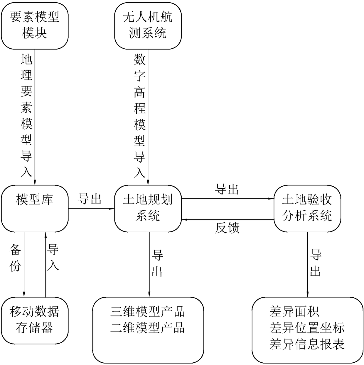
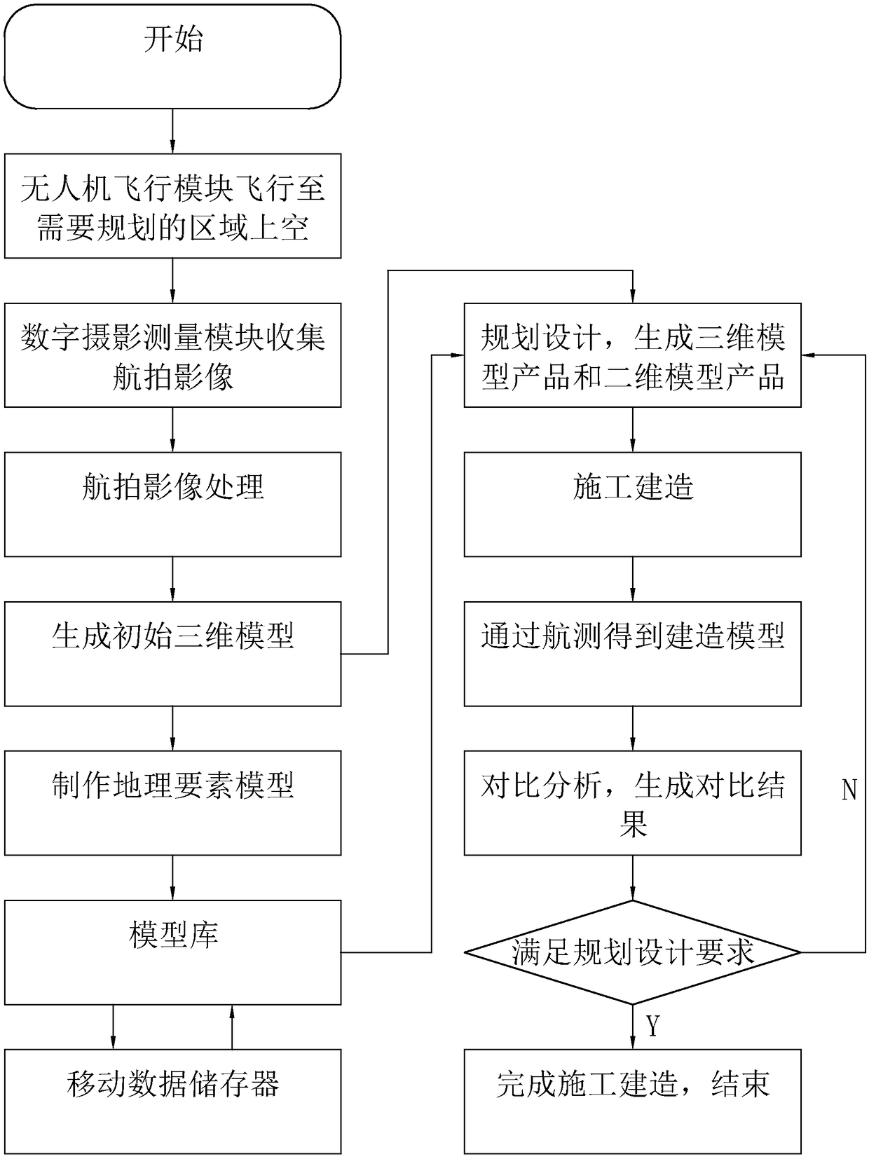
[0040] A land three-dimensional planning and design platform, such as figure 1 As shown, including: UAV aerial survey system, land three-dimensional planning system and land acceptance analysis system.

[0041] UAV aerial survey system includes UAV flight module, digital photogrammetry module, UAV control module and data processing module. The UAV flight module is a quadrotor UAV, which is used to carry the digital photogrammetry module to fly over the area that needs to be planned and designed. The drone control module is used to control and plan the flight route of the drone, and control the landing of the drone after obtaining the aerial image. The digital photogrammetry module is used to photograph the area that needs to be planned and designed to obtain aerial images. The data processing module is used to import aerial images into graphics processing ...


PUM


Abstract

The invention, which relates to the field of land planning and designing, discloses a three-dimensional land planning and design platform and a design method thereof so that a problem of high error rate can be solved. The three-dimensional land planning and design platform is characterized by comprising an unmanned-aerial-vehicle aerial survey system, a three-dimensional land planning system and aland checking, acceptance, and analysis system. The unmanned-aerial-vehicle aerial survey system consists of a digital photography measuring module, an unmanned aerial vehicle flight module, an unmanned aerial vehicle control module and a data processing module. The three-dimensional land planning system includes a data inputting module, a model building module, an element model module, and a planning design module and is used for generating a three-dimensional model product and a two-dimensional model product. The land checking, acceptance, and analysis system consists of a file inputting module and a comparison module and is used for comparing data between the building model and three-dimensional model products and generating a comparison result. Therefore, the manual calculation load is reduced effectively; the error rate is reduced; and proper adjustment is carried out during the building process based on the comparison result, so that the error rate is reduced effectively.

Description

technical field [0001] The invention relates to the field of land planning and design, in particular to a land three-dimensional planning and design platform and a design method thereof. Background technique [0002] Within a certain area, according to the prospects and needs of economic development, long-term arrangements are made for the rational use of land. With the continuous development of the national economy, people have higher requirements for the rationality and scientificity of land planning, and at the same time, the accuracy of land planning and construction has also improved. [0003] In the process of land 3D planning and design, it is necessary to use 2D and 3D models for auxiliary design in order to achieve better design results. With the rapid development of 3D GIS technology and computer technology, 3D GIS software at home and abroad have made great progress in terms of the richness of product functions and the scalability of development interfaces. The ...

Claims


Application Information

Patent Timeline
Patent Type & Authority Applications(China)
IPC IPC(8): G05D1/10G01C11/00G06F17/30G06F17/50
CPCG01C11/00G05D1/101G06F16/29G06F30/13
Inventor 王慎敏周盛周娟娟马其芳蒲阳房隐留曹志峰
Owner 南京和图地理信息工程有限公司
Why Eureka
Try Eureka