Satellite-ground interference coordination method, device and equipment based on radio map information

A radio map and interference coordination technology, applied in the field of communication, can solve the problems of difficult engineering realization of opportunistic resource allocation technology, difficulty in obtaining complete channel state information, etc. Effect

Active Publication Date: 2018-08-24
CHINA ACADEMY OF ELECTRONICS & INFORMATION TECH OF CETC
View PDF3 Cites 10 Cited by
  • Summary
  • Abstract
  • Description
  • Claims
  • Application Information

AI Technical Summary

Problems solved by technology

However, in practical engineering applications, it is difficult to obtain complete channel state information due to overhead, delay, etc.,

Method used


Image

  • Satellite-ground interference coordination method, device and equipment based on radio map information
  • Satellite-ground interference coordination method, device and equipment based on radio map information
  • Satellite-ground interference coordination method, device and equipment based on radio map information

Examples


example 1

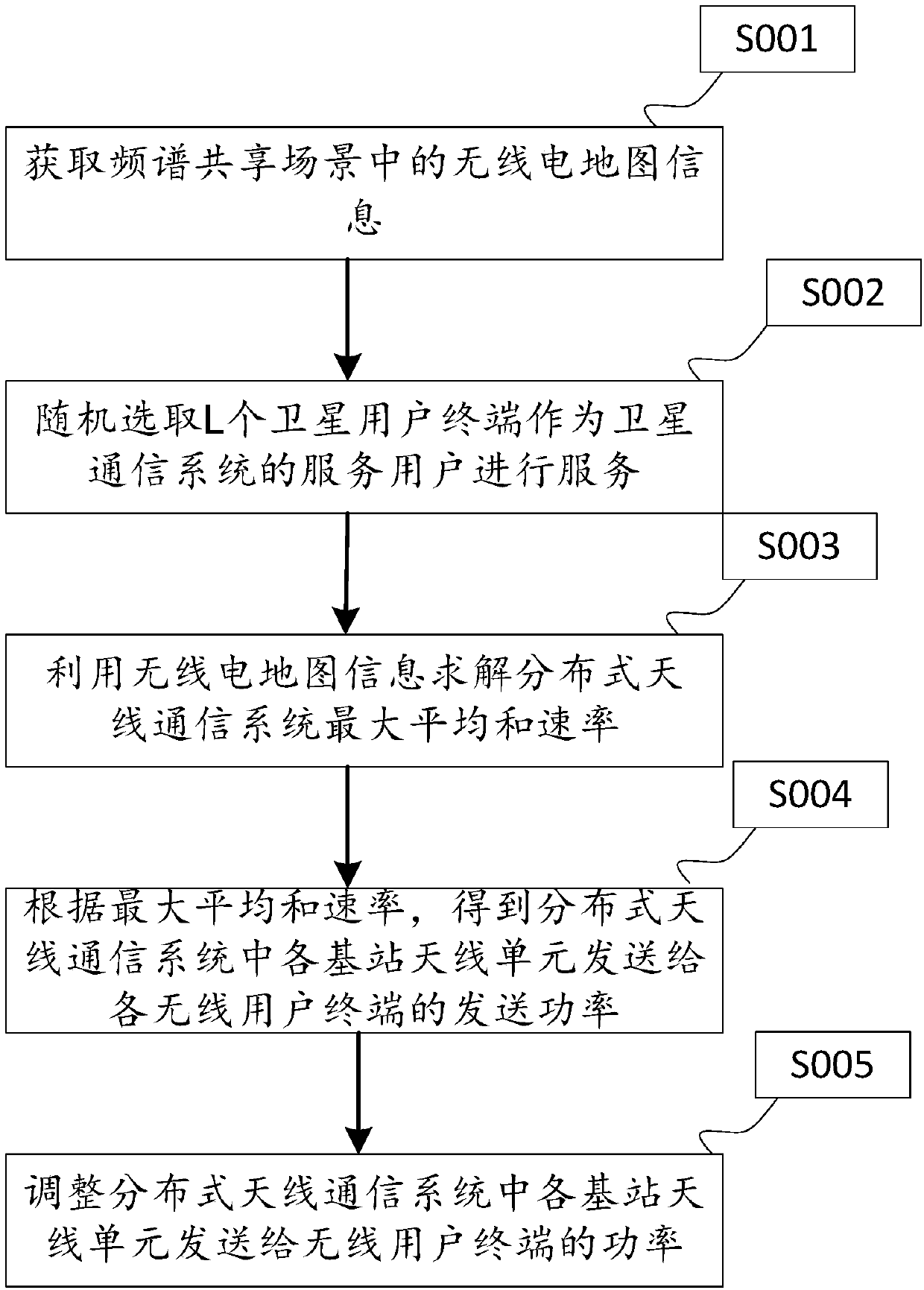
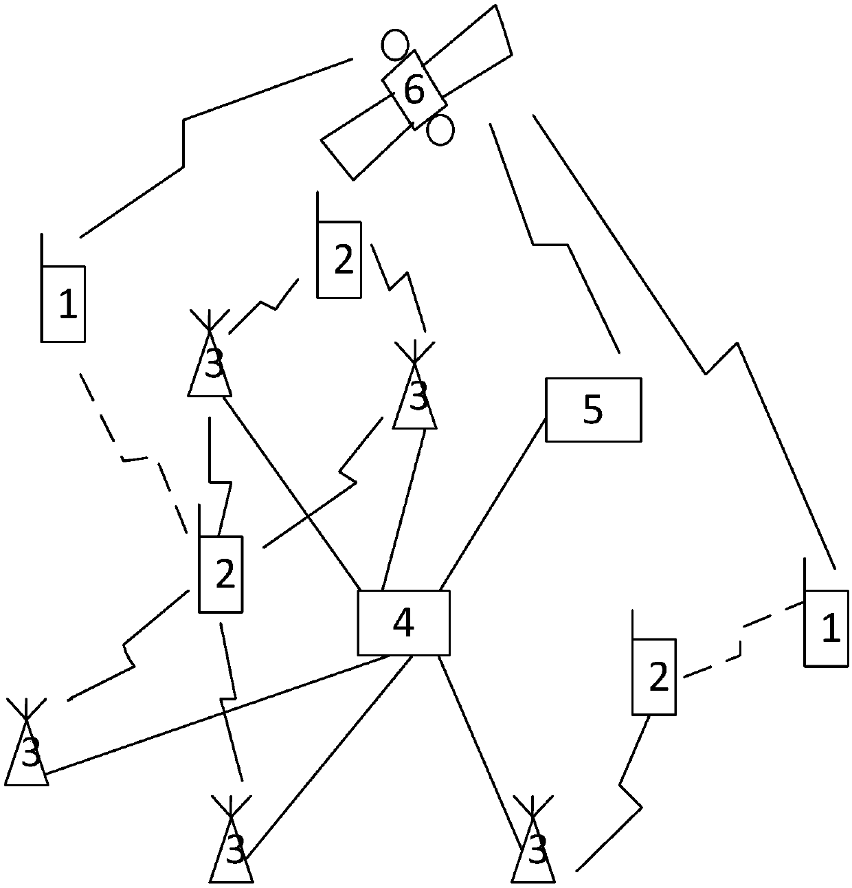
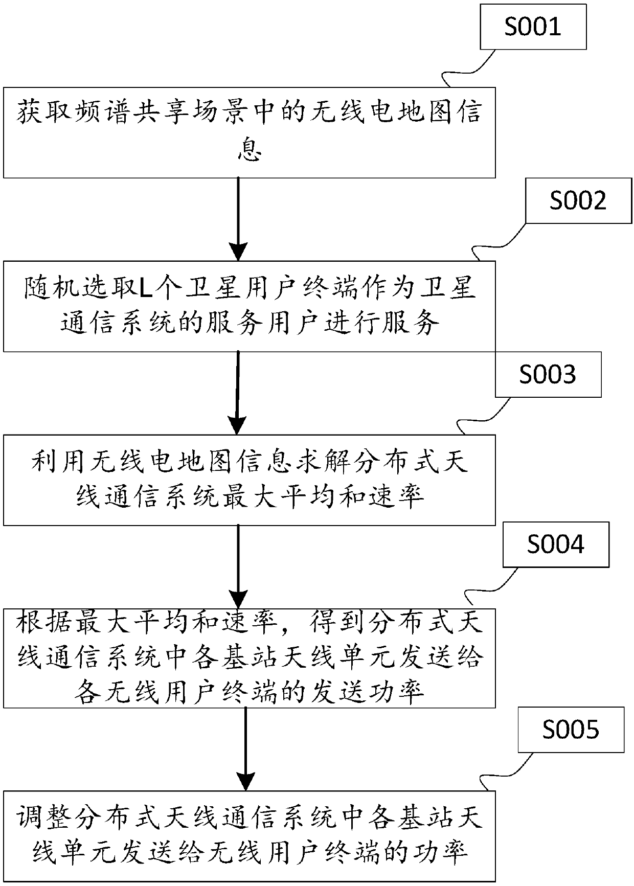
[0086] 1) Set the N DAEs in the DAS system to send signals to the K TUs in the same power mode, that is, the sending power to the K TUs is respectively

[0087] 2) The GSAT system randomly selects L STs from Q STs for service;

[0088] 3) The DAS system optimizes and adjusts the power sent by N DAEs to K TUs

[0089] a) set ι=0; Threshold value ε=1×10 -3 ;

[0090] b) order Into the formula (10), calculate the updated W k ,k=1,...,K, and let ι=ι+1 in the computer execution program;

[0091] c) Based on formula (9), construct the following optimization problem:

[0092]

[0093]

[0094] p kn ≥0,k=1,...,K,n=1,...,N. (11)

[0095] s.t. is the abbreviation of subject to, s.t. means to meet the conditions.

[0096] Solve formula (11), and denote the obtained optimal solution as

[0097] Formula (11) can be solved by means of standard geometric programming and other methods, and the specific steps for solving formula (11) using standard geometric programming are...

example 2

[0123] 1) Set the N DAEs in the DAS system to send signals to the K TUs in the same power mode, that is, the sending power to the K TUs is respectively

[0124] 2) According to the interference to the downlink of the DAS system, without affecting the uplink performance of the system, select L from the Q STs to serve according to the following steps, and calculate the impact of the Q STs on the K STs in the DAS system TU interference and power Will Sort from small to large, and mark the STs corresponding to the first L minimum values ​​as ST1,...,L;

[0125] choose to follow The sorted ST1,...,L are used as uplink service users of the GSAT system;

[0126] 3) The DAS system optimizes and adjusts the power sent by N DAEs to K TUs

[0127] a) set ι=0; Threshold value ε=1×10 -3 ;

[0128] b) order Into the formula (10), calculate the updated W k ,k=1,...,K, and let ι=ι+1 in the computer execution program;

[0129] c) Based on formula (9), construct the following o...

example 3

[0151] 1) Set the N DAEs in the DAS system to send signals to the K TUs in the same power mode, that is, the sending power to the K TUs is respectively

[0152] 2) According to the interference to the downlink of the DAS system, without affecting the uplink performance of the system, select L from the Q STs to serve according to the following steps, and calculate the impact of the Q STs on the K STs in the DAS system The strongest interference power of TU Will Sort from small to large, and mark the STs corresponding to the first L minimum values ​​as ST1,...,L;

[0153] choose to follow The sorted ST1,...,L are used as uplink service users of the GSAT system;

[0154] 3) The DAS system optimizes and adjusts the power sent by N DAEs to K TUs

[0155] a) set ι=0; Threshold value ε=1×10 -3 ;

[0156] b) order Into the formula (10), calculate the updated W k ,k=1,...,K, and let ι=ι+1 in the computer execution program;

[0157] c) Based on formula (9), construct th...


PUM


Abstract

The invention discloses a satellite-ground interference coordination method, device and equipment based on radio map information. The method is suitable for a spectrum sharing scene of a satellite communication system and a distributed antenna communication system, and comprises the following steps of acquiring radio map information in the frequency spectrum sharing scene; utilizing the radio mapinformation to solve a maximum average sum rate of the distributed antenna communication system according to a wireless channel model; obtaining sending power sent to each wireless user terminal by each base station antenna unit in the distributed antenna communication system according to the maximum average sum rate of the distributed antenna communication system; and adjusting power transmittedto the wireless user terminal by each base station antenna unit in the distributed antenna communication system according to the obtained sending power. According to the method, the device and the equipment, efficient frequency spectrum sharing of the satellite communication system and the distributed antenna communication system can be realized, so that the range of shared frequency bands of thesatellite communication system and the distributed antenna communication system is expanded.

Description

technical field [0001] The invention relates to the field of communication technology, in particular to a satellite-ground interference coordination method, device and equipment based on radio map information. Background technique [0002] In order to solve the shortage of wireless spectrum resources and realize the orderly sharing of wireless spectrum resources between the satellite communication system and the distributed antenna communication system, the following two interference coordination methods are mainly used to reduce the mutual interference between the two systems: [0003] 1) Antenna array beamforming based on space division [0004] Utilizing the difference in geospatial location between the transceiver equipment of the satellite communication system (communication satellite and ground station, ground terminal) and the transceiver equipment of the distributed antenna communication system (base station and user terminal), the antenna pattern is adjusted through...

Claims


Application Information

Patent Timeline
IPC IPC(8): H04B17/382H04B17/391H04W52/24H04W52/28
CPCH04B17/382H04B17/3911H04W52/243H04W52/282
Inventor 王燕敏陆洲冯旭柳罡周彬
Owner CHINA ACADEMY OF ELECTRONICS & INFORMATION TECH OF CETC
Why Eureka
Try Eureka