Satellite remote sensing space-time distribution inversion algorithm for column concentration of polluted gas

A pollution gas and satellite remote sensing technology, which is applied in satellite remote sensing and environmental science fields, can solve the problems of lack of space-based remote sensing technology and achieve the effect of improving inversion accuracy and reducing inversion error

Inactive Publication Date: 2018-09-11
UNIV OF SCI & TECH OF CHINA
View PDF3 Cites 20 Cited by
  • Summary
  • Abstract
  • Description
  • Claims
  • Application Information

AI Technical Summary

Problems solved by technology

At present, my country's air pollution observation work is mainly based on the air quality observation network based on ground observation, ...

Method used


Image

  • Satellite remote sensing space-time distribution inversion algorithm for column concentration of polluted gas

Examples


Embodiment Construction

[0022] The following will clearly and completely describe the technical solutions in the embodiments of the present invention with reference to the accompanying drawings in the embodiments of the present invention. Obviously, the described embodiments are only some, not all, embodiments of the present invention. Based on the embodiments of the present invention, all other embodiments obtained by persons of ordinary skill in the art without making creative efforts belong to the protection scope of the present invention.

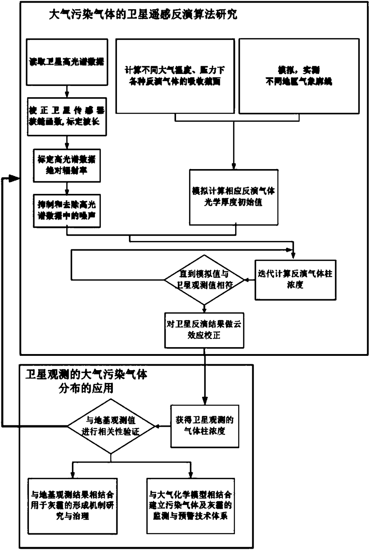
[0023] see figure 1 , a spatial-temporal distribution inversion algorithm of satellite remote sensing pollution gas column concentration, including the following steps:

[0024] The first step: the selection of spectral band and resolution. The differential absorption spectral analysis method is to perform qualitative and quantitative inversion by measuring the characteristic absorption bands of various gas components. Table 1 shows the characteristic spectral...


PUM


Abstract

The invention discloses a satellite remote sensing space-time distribution inversion algorithm for column concentration of polluted gas. The satellite remote sensing space-time distribution inversionalgorithm comprises the following steps: selecting a spectral waveband and a resolution ratio; carrying out difference absorption spectrum analysis method inversion; carrying out contrast verificationon ground-based observation and a chemical model simulation result. The satellite remote sensing space-time distribution inversion algorithm for the column concentration of the polluted gas has the advantages that 1) the quantity/position of detected damaged pixels is judged and identified through fitting residuals and the signal-to-noise ratio of a detector is calculated; 2) key parameters including a slit function, spectrum drifting and the like, which are changed in real time after the simulated detector is launched into the sky, can be realized, the inversion errors are reduced and the inversion precision is improved; 3) overlapping influences on different trace gas spectrums in fitting calculation and influences on atmosphere ring effects are eliminated; 4) the satellite remote sensing space-time distribution inversion algorithm can be applied to an atmospheric pollution gas absolute total amount inversion algorithm of ground-based and onboard observation; 5) an actual atmospheric outline of China is combined with land surface emissivity and a detector posture to construct an atmospheric quality factor lookup table which is changed along wavelength.

Description

technical field [0001] The invention relates to the fields of environmental science and satellite remote sensing technology, in particular to a satellite remote sensing pollution gas column concentration time-space distribution inversion algorithm. Background technique [0002] With the increasing severity of environmental problems and the increasingly obvious trend of internationalization, the necessity and urgency of solving environmental problems are increasingly recognized by countries all over the world. Satellite and aircraft remote sensing technology has incomparable advantages in the field of environmental monitoring due to its unique characteristics of high coverage, rapidity, multi-spectrum, and large amount of information. At present, my country's air pollution observation work is mainly based on the air quality observation network based on ground observation, and there is a lack of space-based (airborne / satellite) remote sensing technology focused on regional / glo...

Claims


Application Information

Patent Timeline
IPC IPC(8): G01N21/31G06F19/00
CPCG01N21/31G16C20/30
Inventor 刘诚
Owner UNIV OF SCI & TECH OF CHINA
Why Eureka
Try Eureka