Visual SLAM-based cognitive point cloud map creation system

A map creation and map technology, applied in the field of cognitive point cloud map creation system

Active Publication Date: 2018-10-12
SOUTH CHINA UNIV OF TECH
View PDF6 Cites 17 Cited by
  • Summary
  • Abstract
  • Description
  • Claims
  • Application Information

AI Technical Summary

Problems solved by technology

The maps created by current visual SLAM are not yet well suited for mobile robots to underst

Method used


Image

  • Visual SLAM-based cognitive point cloud map creation system
  • Visual SLAM-based cognitive point cloud map creation system
  • Visual SLAM-based cognitive point cloud map creation system

Examples


Embodiment Construction

[0091] The present invention will be further described in detail below in conjunction with the embodiments and the accompanying drawings, but the embodiments of the present invention are not limited thereto.

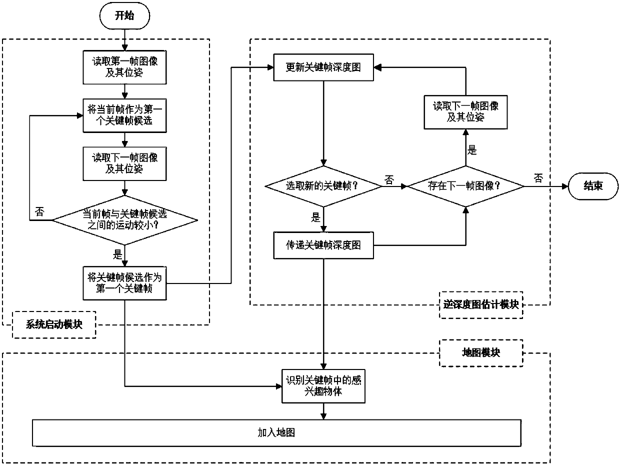
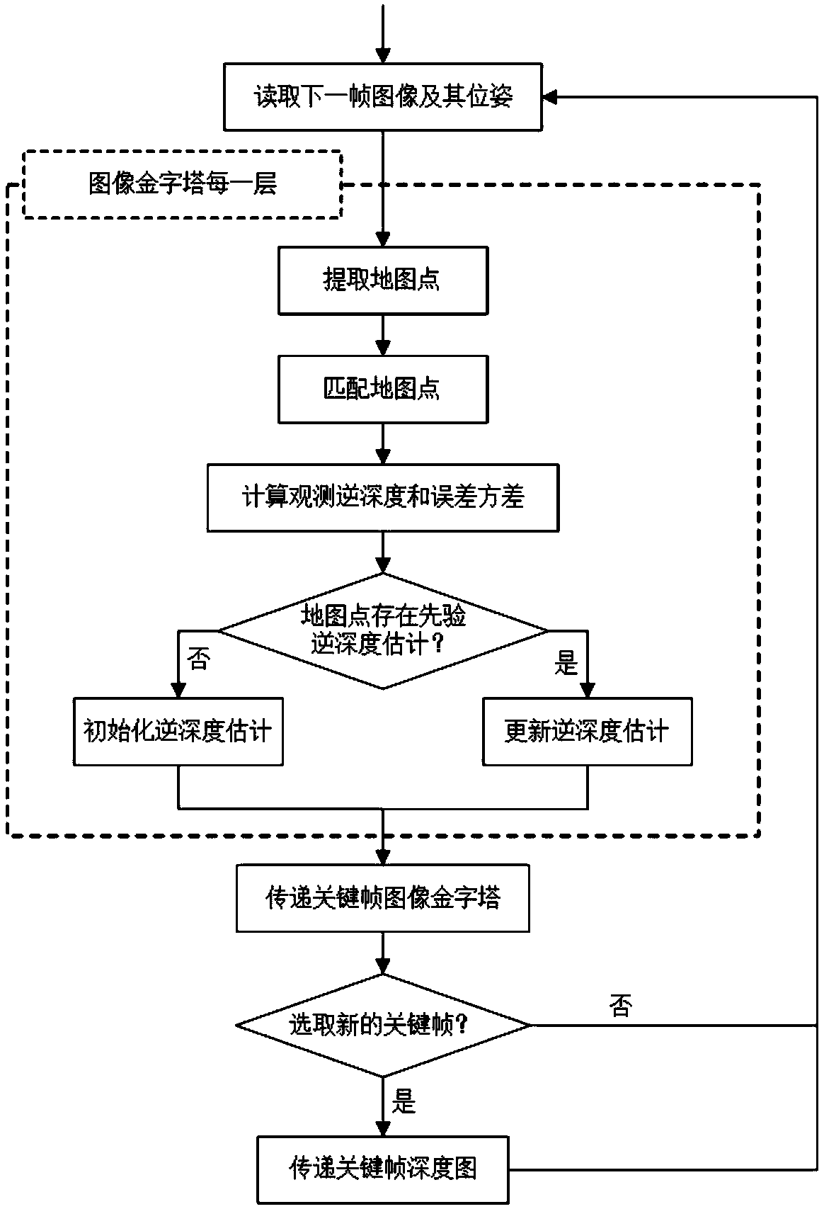
[0092] see figure 1 As shown, the cognitive point cloud map creation system of visual SLAM provided by this embodiment includes modules:

[0093] The system startup module selects the first key frame according to the range of motion of the camera, and the range of motion of the camera is described by the pose transformation between two frames of images represented by the Lie algebra se(3), including the following steps:

[0094] 1.1) Read the first frame image and use it as the first key frame candidate, only when it meets certain conditions can it really become the first key frame;

[0095] 1.2) Read the next frame image, and judge whether the motion range between it and the key frame candidate is small, the specific operation is as follows:

[0096] Let ξ∈se(3) repre...


PUM


Abstract

The invention discloses a visual SLAM-based cognitive point cloud map creation system, and aims at obtaining image pose information by utilizing visual SLAM so as to estimate relative dense reverse depth information of environment, recognizing interested objects in the environment and creating a cognitive point cloud map of the environment. The system comprises a system starting module, a reversedepth map estimation module and a map module, wherein the system starting module is responsible for selecting a first key frame; the reverse depth map estimation module is responsible for estimating areverse depth map of the key frame and selecting a new key frame; and the map module is responsible for maintaining the created cognitive point cloud map, recognizing interested objects in the key frame when the new key frame is added into the map, and visually displaying the map creation. According to the system, the relatively dense cognitive point cloud map of the environment is created by utilizing image information, the map is capable of realizing positioning of mobile robots, obstacle avoidance, autonomous navigation and three-dimensional environment reconstruction, and cognitive information in the map can be used for realizing interaction between the mobile robots and human beings and interaction between the mobile robots and the environment.

Description

technical field [0001] The present invention relates to the fields of visual SLAM, inverse depth estimation, object recognition and map creation, in particular to a cognitive point cloud map creation system for visual SLAM. Background technique [0002] Simultaneous Localization and Mapping (SLAM) is an important way to realize the intelligent perception of robots. It was first proposed at the IEEE Robotics and Automation Conference in 1986. In an unknown environment, the mobile robot obtains environmental information through its own sensors, and constantly estimates its own pose during the movement process, and at the same time creates a map of its surrounding environment. SLAM is mainly used to solve the "positioning" and "map creation" of mobile robots. On the one hand, mobile robots need to know where they are currently on the map (positioning), and on the other hand, they need to create a map of the surrounding environment (map creation). SLAM that acquires environment...

Claims


Application Information

Patent Timeline
IPC IPC(8): G06T17/05G06T7/90
CPCG06T7/90G06T17/05G06T2207/10028G06T2207/20016G06T2207/20081G06T2207/20104
Inventor 董敏裴茂锋毕盛
Owner SOUTH CHINA UNIV OF TECH
Why Eureka
Try Eureka