Multi-source information fusion based rainfall estimation method

A multi-source information fusion and rainfall technology, which is applied to rainfall/precipitation gauges, measuring devices, climate change adaptation, etc., can solve problems such as deviations in estimation results, achieve reliable data input, avoid flood risks or small watershed rainstorms and floods Estimate and strengthen the effect of regional high-precision disaster early warning

Active Publication Date: 2018-11-06
POWERCHINA BEIJING ENG
View PDF5 Cites 43 Cited by
  • Summary
  • Abstract
  • Description
  • Claims
  • Application Information

AI Technical Summary

Problems solved by technology

Each type of satellite-observed rainfall data comes from different platforms and has its own format and standard; currently, using only one type of data for rainfall estimation can easily cause deviations in estimation results due to errors in observation data, which is not conducive to Provide accurate data support for geological disaster monitoring, flood control and drought relief

Method used


Image

  • Multi-source information fusion based rainfall estimation method
  • Multi-source information fusion based rainfall estimation method
  • Multi-source information fusion based rainfall estimation method

Examples


specific Embodiment approach

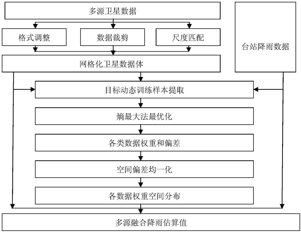
[0112] This specific embodiment discloses a method for estimating rainfall based on multi-source information fusion, including the following steps:

[0113] Step 1: Multi-source satellite rainfall data preprocessing, as follows:

[0114] First, select the rainfall data observed by the ground stations in the study area and the appropriate satellite rainfall data source. The available satellite data sources include TRMM 3B42RT, TRMM 3B42V7, GPM IMERG, PERSIANN, GsMap, CPC CMORPH and FY-2E formats .

[0115] Then, the satellite rainfall data are preprocessed, decompiled according to their respective formats, and invalid and illegal values ​​in the data are eliminated,

[0116] Finally, check the coordinate grid range and effective time interval of each satellite rainfall data to confirm that the research area is within the control range of the selected data and the time interval meets the work requirements.

[0117] Step 2: Multi-source satellite rainfall data volume constructi...


PUM


Abstract

The invention provides a multi-source information fusion based rainfall estimation method. The multi-source information fusion based rainfall estimation method includes: combining ground station observation rainfall data in a study area with a multi-source satellite rainfall data body in the study area to form a multi-source data set in the study area; establishing a dynamic Bayesian theory basedBayesian rainfall prediction model; using the maximum entropy method to obtain a nonlinear optimal solution of the Bayesian rainfall prediction model, and then determining the optimal weight and uncertainty information of each satellite data source; and generating an estimation result using the multi-source information fusion rainfall in the study area. The advantages of the invention are that theresult of multi-data source fusion analysis can reduce the uncertainty of the regional rainfall estimation due to the inaccuracy of a single type of rainfall information; and more reliable data inputand richer and more refined modeling data are provided for strengthening regional high-precision disaster warning, avoiding the flood risk or small watershed rainstorm flood estimation.

Description

technical field [0001] The invention belongs to the technical field of rainfall estimation, and in particular relates to a rainfall estimation method based on multi-source information fusion. Background technique [0002] Rainfall is a key link in the circulation process of the hydrological system and plays a vital role in the entire water cycle, and the huge changes in rainfall in a short period of time can easily cause regional geological and environmental problems, such as urban water accumulation, mountainous areas Problems such as geological disasters or floods in river basins have caused serious damage to socio-political and economic development. How to accurately estimate regional rainfall in a relatively short period of time is one of the key issues that need to be solved urgently in the field of water information. [0003] With the development of observation methods and levels, satellite observation of surface rainfall technology has made great progress, providing ...

Claims


Application Information

Patent Timeline
Patent Type & Authority Applications(China)
IPC IPC(8): G01W1/14
CPCG01W1/14Y02A50/00
Inventor 张国宝高立东李善飞李维垚郭继亮胡小青王丹刘慧文李小超张佳宾
Owner POWERCHINA BEIJING ENG
Why Eureka
Try Eureka