Vive virtual globe roaming browsing method based on osgearth

An earth and digital earth technology, applied in the field of geographic information system, can solve the problems of small scene scope and artificial scene modeling, and achieve the effect of realistic effect, strong sense of reality, and convenient operation and use.

Active Publication Date: 2022-01-04
THE CHINESE PEOPLES LIBERATION ARMY 92859 TROOPS
View PDF3 Cites 0 Cited by
  • Summary
  • Abstract
  • Description
  • Claims
  • Application Information

AI Technical Summary

Problems solved by technology

[0006] Although the current VR equipment brings people a better virtual space experience, there are still some shortcomings, which can be summarized as follows: (1) Most of the scenes are artificially modeled, not real data from the real world; (2) The scope of the scene is small

Method used


Image

  • Vive virtual globe roaming browsing method based on osgearth
  • Vive virtual globe roaming browsing method based on osgearth
  • Vive virtual globe roaming browsing method based on osgearth

Examples


Embodiment Construction

[0036] The present invention will be described in further detail below in conjunction with the accompanying drawings.

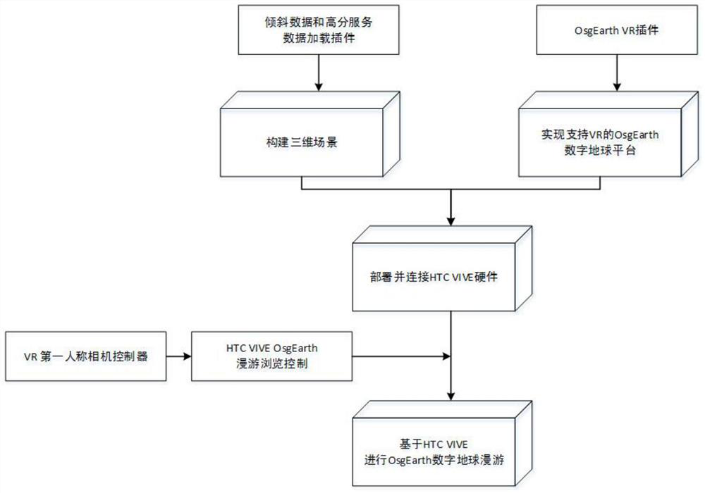
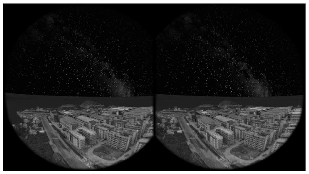
[0037] A kind of roaming browsing method of VIVE virtual globe based on OsgEarth, such as figure 1 shown, including the following steps:

[0038] Step 1. Based on the OsgEarth digital earth platform, construct a 3D geographic information scene. The specific method is as follows:

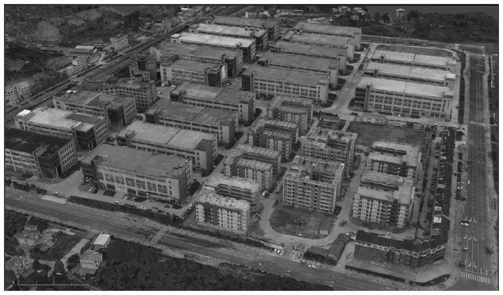
[0039] First of all, the data required to construct a 3D geographic scene are acquired through surveying and mapping methods, mainly including: (1) DOM image data reflecting landforms. Mosaic, uniform light and color processing, etc., to meet certain precision index requirements; (2) DEM elevation data reflecting terrain features, which are obtained through aerospace stereo photography and other means; (3) oblique photography data reflecting architectural details, these The data is acquired by means of aerial oblique photography and edited manually.

[0040] Then, the above-ment...


PUM


Abstract

The present invention relates to a roaming and browsing method of VIVE virtual earth based on OsgEarth, which is characterized in that: based on the OsgEarth digital earth platform, a three-dimensional geographical information scene is constructed; a plug-in applicable to the OsgEarth digital earth platform is constructed based on OpenVR; a plug-in applicable to the OsgEarth digital earth platform is used , to arrange and connect HTC VIVE hardware devices; use the first-person perspective camera controller and use HTC VIVE to perform roaming control on the OsgEarth digital earth. The present invention combines OpenVR technology and OsgEarth technology to establish a link between HTC VIVE hardware equipment and OsgEarth software platform; and through the coordinate transformation relationship between real space, virtual space, projection space and equipment space, OsgEarth digital earth platform VR is constructed The roaming first-view camera controller realizes the global VR roaming browsing control function. It has the characteristics of realistic effect, strong sense of reality, and convenient operation and use. It can be widely used in the field of geographic information applications.

Description

technical field [0001] The invention belongs to the technical field of geographic information systems, in particular to an OsgEarth-based VIVE virtual earth roaming browsing method. Background technique [0002] The three-dimensional geographic information system represented by digital earth has obvious advantages compared with the traditional two-dimensional geographic information system in terms of the analyzability of geographic information and the intuitiveness of geographic information expression. At present, there are many successful digital earth products at home and abroad, such as GoogleEarth, ArcGlobe, Virtual Earth, EV-Globe, etc., but these commercial platforms are more or less deficient in terms of openness, portability, and customization. OsgEarth is an open source digital earth platform developed based on the OpenSceneGraph 3D graphics rendering engine. It has good scalability, openness and portability, and has attracted extensive and in-depth research in the ...

Claims


Application Information

Patent Timeline
Patent Type & Authority Patents(China)
IPC IPC(8): G06T19/00G06T17/05G06F16/29G06F16/954G06F8/20
CPCG06F8/22G06T19/006
Inventor 赵健刘玉红闸旋郭忠磊李海滨申家双
Owner THE CHINESE PEOPLES LIBERATION ARMY 92859 TROOPS
Why Eureka
Try Eureka