Method and device for constructing high-precision map

A high-precision, map technology, used in maps/plans/charts, instruments, educational appliances, etc., can solve problems such as high prices, high equipment cost and skill level requirements, and increased system and production process complexity. The effect of reducing storage and transmission pressure, eliminating skill level dependencies, and improving update efficiency

Inactive Publication Date: 2018-11-20
SHENZHEN HORIZON ROBOTICS TECH CO LTD
View PDF12 Cites 14 Cited by
  • Summary
  • Abstract
  • Description
  • Claims
  • Application Information

AI Technical Summary

Problems solved by technology

[0003] For high-precision maps, it is usually necessary to use expensive lidar and high-precision positioning sensors to collect point cloud data, and then professional technicians perform a series of operations on the point cloud data such as data cleaning, splicing, alignment, data vectorization, and indexing , so the cost of equipment and the requirements for the skill level of professionals are very high, making it difficult to deploy high-precision maps on a large scale, and greatly limiting the update frequency of high-precision maps
In addition, every link of the usual high-precision map production process requires manual participation, which also greatly limits the production efficiency of high-precision maps
[0004] In addition, in the production process of the usual high-precision map, in order to obtain the structure and color information of the scene at the same time, it is often necessary to use the camera and the lidar sensor at the same time. Increased system and process complexity
[0005] In addition, the high-precision map made in the usual way may contain a large amount of redundant information or potential dynamic objects that are currently stationary but actually moveable, thus increasing the pressure on the storage and transmission of the high-precision map, thus extremely The earth limits the update efficiency of high-precision maps

Method used


Image

  • Method and device for constructing high-precision map
  • Method and device for constructing high-precision map

Examples


Embodiment Construction

[0017] An example of a method and an apparatus for constructing a high-precision map according to an embodiment of the present disclosure will be described below with reference to the accompanying drawings.

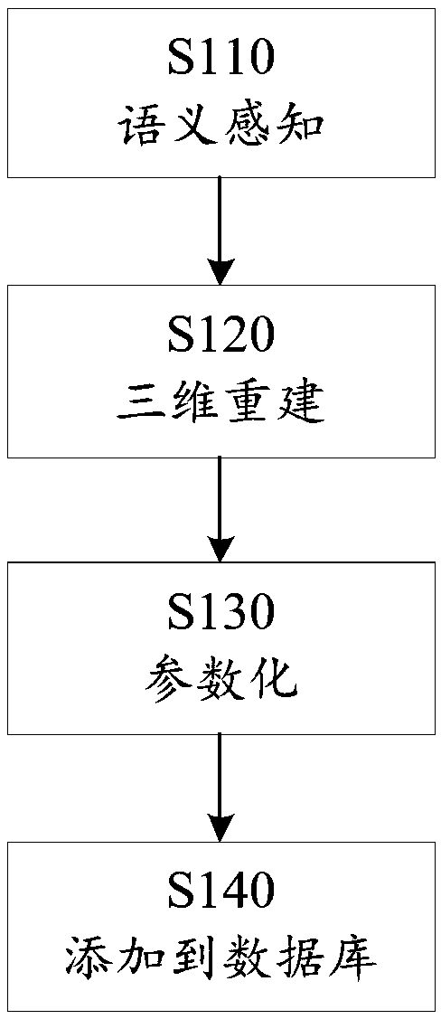
[0018] Such as figure 1 As shown, the method according to the embodiment of the present disclosure may start at step S110 to perform semantic perception on one or more images from the on-board camera of the vehicle based on a deep learning algorithm.

[0019] In one embodiment, one or more appropriate deep learning algorithms or models can be used to determine the category of the map element to which each pixel in each image belongs, to detect the boundaries of landmarks of interest in each image, and to determine the category of the landmark, and determine the correlation between the two consecutive images of the landmark of interest, thereby performing the semantic perception in step S110.

[0020] The present disclosure is not limited to any particular deep learning a...


PUM


Abstract

The invention discloses a method and a device for constructing a high-precision map. The method comprises the steps of performing semantic sensing on one or a plurality of images of an on-vehicle camera from a vehicle based on a deep learning algorithm; performing three-dimensional reconstruction on an attention road sign according to vehicle attitude data and a semantic sensing result; parameterizing a three-dimensional reconstruction result; and adding a parameterizing result into a high-precision map database. The method and the device according to the invention have advantages of greatly reducing manufacturing cost of the high-precision map, facilitating data acquisition mode in a crowdsourcing manner and increasing update frequency of the high-precision map.

Description

technical field [0001] The present disclosure generally relates to the technical field of automatic driving, and in particular relates to a method and device for constructing high-precision maps in a low-cost manner. Background technique [0002] Autonomous driving often requires the use of high-resolution maps. Such high-precision maps can achieve centimeter-level accuracy and contain richer detailed information (e.g., road slope, curvature, etc.) than digital maps, which are crucial for vehicle navigation, localization, control, and safety. [0003] For high-precision maps, it is usually necessary to use expensive lidar and high-precision positioning sensors to collect point cloud data, and then professional technicians perform a series of operations on the point cloud data such as data cleaning, splicing, alignment, data vectorization, and indexing , so the cost of equipment and the requirements for the skill level of professionals are very high, which makes it difficult...

Claims


Application Information

Patent Timeline
Patent Type & Authority Applications(China)
IPC IPC(8): G09B29/00
CPCG09B29/005G09B29/007
Inventor 杨帅
Owner SHENZHEN HORIZON ROBOTICS TECH CO LTD
Why Eureka
Try Eureka