
UAV image segmentation method considering three-dimensional and edge shape features of building

A shape feature and image segmentation technology, applied in image analysis, image enhancement, image data processing, etc., can solve problems such as wrong merging of building areas, difficult selection of scale parameters, and difficulty in using image edge shape features, etc., to achieve operability Strong, clear processing effect

Active Publication Date: 2018-12-07
WUHAN UNIV
View PDF6 Cites 10 Cited by
  • Summary
  • Abstract
  • Description
  • Claims
  • Application Information

AI Technical Summary

Problems solved by technology

The traditional segmentation method based on spectral and shape heterogeneity will encounter greater uncertainty due to the "average" of the features of the segmented object during the merging process. The scale parameters in the segmentation method are difficult to choose and have no definite physical meaning. The edge shape features in the image are difficult to use and the 3D elevation information is only used as another 1D "2D" band information, which may cause the building area and non-building area in the segmentation result to be mistakenly merged, making it difficult for subsequent object-oriented Image analysis generates the correct analysis object

Method used


Image

  • UAV image segmentation method considering three-dimensional and edge shape features of building
  • UAV image segmentation method considering three-dimensional and edge shape features of building
  • UAV image segmentation method considering three-dimensional and edge shape features of building

Examples


Embodiment Construction

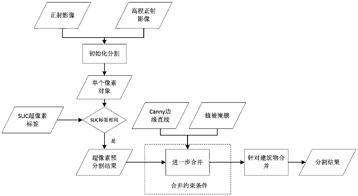
[0051] The method for segmentation of UAV images that takes into account the three-dimensional and edge shape features of buildings provided by the present invention is to set the segmentation scale parameter for the maximum object area that needs to be extracted, mask the invalid area, and convert the input ortho A single pixel of the corrected image, elevation orthophoto, and SLIC label image is regarded as an object, and the segmentation process is initialized; pre-segmentation based on SLIC superpixel is performed, and adjacent pixel objects are found for the initial pixel object. If the SLIC labels are the same, then merge , Until all pixel objects with the same label are merged together; add Canny edge line information and vegetation mask information, and perform edge labeling and vegetation labeling on a single superpixel segmented object in the superpixel pre-segmentation result; find objects in each The most similar object under a constraint condition, and determine whe...


PUM


Abstract

The invention provides a UAV (unmanned aerial vehicle) image segmentation method considering three-dimensional and edge shape features of a building. The method comprises a step of setting segmentation scale parameters according to a maximum object area to be extracted, masking an invalid region, taking each single pixel of an inputted orthorectified corrected image, an elevation orthorectified image and a SLIC tag image as an object, and initializing the segmentation process, a step of finding an adjacent pixel object for an initial pixel object, performing merging if a SLIC tag is the same until pixel objects with the same tag are merged together, a step of adding Canny edge line information and vegetation mask information to perform edge labeling and vegetation labeling on a single superpixel segmentation object in a superpixel pre-segmentation result, a step of performing loop iteration, finding most similar objects of the object under various constraint conditions, judging whetherthe merging of the most similar objects and a current object is suitable and performing repeated iteration until there is no object to merge, and step of carrying out optimized merging on a small-area region which is not merged yet in a result.

Description

Technical field [0001] The present invention relates to the technical field of remote sensing image processing, in particular to an unmanned aerial vehicle image segmentation method that takes into account the three-dimensional and edge shape characteristics of buildings. Background technique [0002] As the spatial resolution of remote sensing images increases, Object Based Image Analysis (OBIA) has gradually become an effective high-spatial resolution image analysis tool. Object-level image analysis can reduce the spectral differences within the ground features and reduce the salt and pepper noise in the results. Image segmentation is a decisive step in object-level image analysis, such as feature recognition, information extraction, or image classification. The flying height of drones is generally low, the image spatial resolution is very high, and it is closer to the close-up image. Therefore, a single object is clearer, the spectral difference inside the object becomes larg...

Claims


Application Information

Patent Timeline
Patent Type & Authority Applications(China)
IPC IPC(8): G06T7/13G06T7/187
CPCG06T2207/10004G06T2207/10032G06T7/13G06T7/187
Inventor 孙开敏李文卓李鹏飞白婷眭海刚
Owner WUHAN UNIV
Learn More