Remote sensing estimation method for thickness of sea ice

A remote sensing and altitude technology, applied in the application field of remote sensing geology, can solve the problems of difficult application of physical model method, low inversion accuracy, poor fitting accuracy, etc.

Inactive Publication Date: 2019-01-11
NANJING UNIV
View PDF2 Cites 13 Cited by
  • Summary
  • Abstract
  • Description
  • Claims
  • Application Information

AI Technical Summary

Problems solved by technology

Among the existing waveform re-tracking methods, the physical model method is difficult to apply, and often has no solution; the threshold method is relatively simple, and it is difficult to meet the needs of large-scale sea ice thickness inversion; the simple waveform fitting method has poor fitting accuracy, Inversion accuracy is low

Method used


Image

  • Remote sensing estimation method for thickness of sea ice
  • Remote sensing estimation method for thickness of sea ice
  • Remote sensing estimation method for thickness of sea ice

Examples


Embodiment Construction

[0039] The present invention will be described in detail below according to the accompanying drawings, so as to make the technical route and operation steps of the present invention clearer. The data used in the examples of the present invention are CryoSat-2 satellite L1b level SAR model data and the 10km resolution sea ice type data OSI SAF of the Ocean Sea Ice Application Center of the European Meteorological Satellite Application Organization. The CryoSat-2 data was acquired from March 1, 2015 to March 30, 2015, and the OSI SAF data was acquired from March 15, 2015.

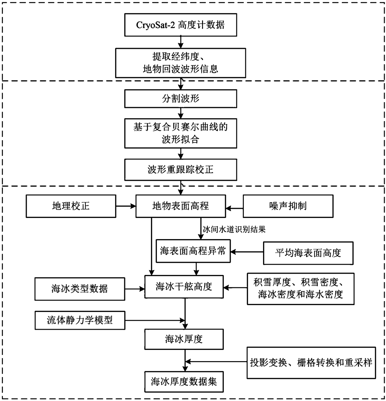
[0040] figure 1 It is the flow chart of sea ice thickness remote sensing estimation method, and the specific steps are as follows:

[0041]The first step is to prepare the data, and extract and filter the data, including the following two aspects:

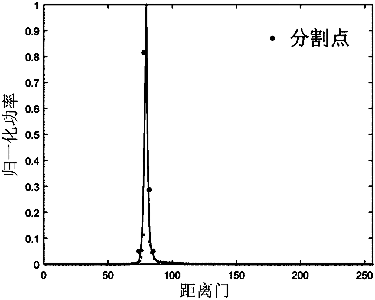
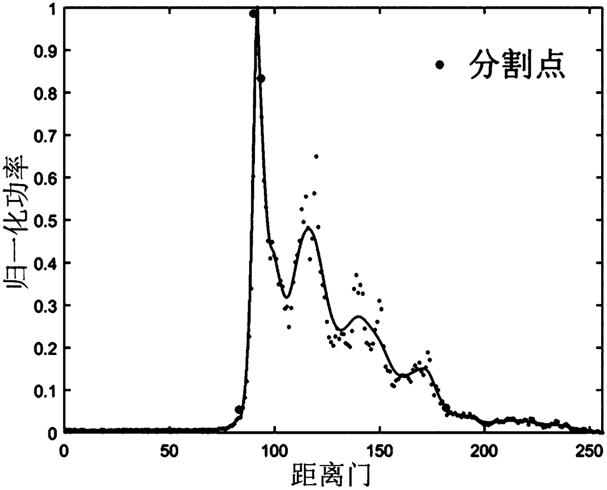
[0042] Ⅰ. Download the CryoSat-2 satellite altimeter SAR mode L1b level data, and extract the latitude and longitude coordinates, surface object echo waveform c...


PUM


Abstract

The invention discloses a remote sensing estimation method for the thickness of sea ice. The remote sensing estimation method comprises the steps that a ground echo waveform is obtained from a CryoSat-2 radar altimeter, a raw echo waveform is fit through a composite cubic Bezier curve, the position of a waveform re-tracking point is solved, the freeboard height of the sea ice is calculated, and meanwhile, data such as the accumulated snow depth and the sea ice type in the same period are obtained; the data are subjected to geographical coordinate matching to obtain point data containing the freeboard height of the sea ice, the accumulated snow depth and the sea ice type; different sea ice densities are given to one-year ice and multiyear ice, by combining the accumulated snow density withthe seawater density, the thickness of the sea ice is estimated through a hydrostatic model, and finally a sea ice thickness distribution diagram in a study area is obtained through projection transformation, raster conversion and space resampling. According to the remote sensing estimation method, a novel waveform re-tracking method, namely a composite cubic Bezier curve fitting method, is adopted, the problem that an original method is sensitive to the surface characteristics of ground features is solved, and thus the estimation accuracy of the thickness of the sea ice is improved.

Description

technical field [0001] The invention relates to a remote sensing estimation method for sea ice thickness, belonging to the technical field of remote sensing geoscience applications. technical background [0002] Sea ice is one of the most sensitive environmental factors in the climate system, which has an important impact on the material balance and heat exchange process in the region. Sea ice thickness is one of the most important characteristics to describe the nature of sea ice, and it is also a common index to describe sea ice changes. In the past 50 years, the thickness of Arctic sea ice has shown a continuous downward trend, and the degree of reduction varies in different regions and seasons. The thicker multi-year ice has the largest reduction in thickness, which has had a profound impact on the Arctic climate. Global climate change. Therefore, studying changes in sea ice thickness has important practical significance for understanding the mechanism of climate chang...

Claims


Application Information

Patent Timeline
Patent Type & Authority Applications(China)
IPC IPC(8): G01C13/00
CPCG01C13/00
Inventor 柯长青沈校熠李萌萌夏文韬
Owner NANJING UNIV
Why Eureka
Try Eureka