Indoor and outdoor combined navigation device based on STM32

An integrated navigation, indoor and outdoor technology, applied in the field of indoor and outdoor integrated navigation devices, can solve the problems of being easily affected by the environment, low absolute positioning accuracy, and high cost

Pending Publication Date: 2019-01-11
格物智航(深圳)科技有限公司
View PDF8 Cites 0 Cited by
  • Summary
  • Abstract
  • Description
  • Claims
  • Application Information

AI Technical Summary

Problems solved by technology

Positioning technologies based on WIFI, Bluetooth, and RFID depend on the geometric distribution of signals, are easily affected by the environment, and have low absolute positioning accuracy; positioning technologies based on UWB need to be equipped with corresponding hardware devices, and the cost is high; while positioning technologies based on PDR, Although the positioning results are continuous and have strong autonomy, there are cumulative errors and absolute positioning information cannot be obtained

Method used


Image

  • Indoor and outdoor combined navigation device based on STM32
  • Indoor and outdoor combined navigation device based on STM32
  • Indoor and outdoor combined navigation device based on STM32

Examples


Embodiment Construction

[0061] The present invention will be further described below in conjunction with the accompanying drawings and specific embodiments.

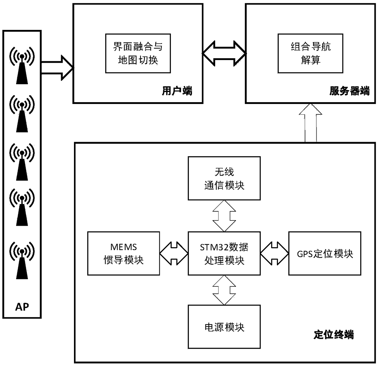
[0062] like figure 1 A kind of indoor and outdoor integrated navigation device based on STM32 as shown is characterized in that: it includes a positioning terminal solid on the body, a server end and a client end, and the positioning terminal includes a GPS positioning module, a MEMS inertial navigation module, and a wireless communication module And STM32 data processing module, described GPS positioning module, MEMS inertial navigation module, wireless communication module are connected with STM32 data processing module respectively, described positioning terminal is connected with server end wireless communication, and described user end is connected with server end wireless communication;

[0063] The positioning terminal realizes the data processing and control of the GPS positioning module, the MEMS inertial navigation module, and the wir...


PUM


Abstract

The invention discloses an indoor and outdoor combined navigation device based on STM32. According to the device, through data interaction among a client, a server and a positioning terminal, a suitable combined navigation policy is selected, so continuous and reliable positioning service is provided in various scenes. The positioning terminal preprocesses MEMS sensor data and GPS data through application of an STM32 data processor, sends the preprocessed navigation information to the server, selects the suitable combined navigation policy through combination of Wi-Fi information sent by the client, carries out recursive filtering calculation through adoption of the optimal kalman filter, obtains the optimal estimation of an error state and corrects an inertial navigation result which provides continuous positioning service. The client receives an indoor and outdoor combined navigation result calculated by the server, realizes mode switching of an outdoor map and an indoor map on a friendly user interface, and provides relatively comfortable navigation service for a user.

Description

technical field [0001] The invention relates to the field of navigation, in particular to an STM32-based indoor and outdoor integrated navigation device. Background technique [0002] With the rapid development of positioning and navigation technology, the traditional single navigation method is difficult to meet the accuracy, reliability and real-time requirements of the navigation system. Integrated navigation information fusion technology has gradually become the main direction of navigation technology research. Information fusion, also known as data fusion, was first proposed by the United States Department of Defense Laboratory Council in the early 1970s. Information fusion correlates and fuses homogeneous or heterogeneous navigation information from different navigation sources to achieve the purpose of de-falsification and sublimation of information, and finally obtain accurate and complete navigation information. The integrated navigation system is a multi-sensor in...

Claims


Application Information

Patent Timeline
Patent Type & Authority Applications(China)
IPC IPC(8): G01C21/16G01S19/47H04W4/024H04W4/33H04W48/10H04W48/16
CPCH04W4/024H04W4/33H04W48/10H04W48/16G01C21/165G01S19/47
Inventor 王晨琳刘海颖韩金龙
Owner 格物智航(深圳)科技有限公司
Why Eureka
Try Eureka