Navigation method of INS-assisted GNSS scalar tracking ring

A navigation method and scalar tracking technology, applied in the field of satellite positioning and navigation, can solve problems such as limited anti-interference ability, achieve low hardware resource requirements, improve navigation performance, and facilitate transformation

Pending Publication Date: 2019-02-05
BEIJING INSTITUTE OF TECHNOLOGYGY
View PDF5 Cites 0 Cited by
  • Summary
  • Abstract
  • Description
  • Claims
  • Application Information

AI Technical Summary

Problems solved by technology

[0004] At present, INS-assisted GNSS receiver technology mainly uses INS-assisted carrier PLL technology to improve the tracking ability of vehicle navigation receivers. This method has limited ability to improve the anti-jamming ability of traditional missile-borne GNSS receivers in high dynamic environments, and needs to adopt new INS-assisted GNSS Receiver technology to improve the satellite tracking ability in high dynamic weak signal environment, thereby improving the anti-jamming ability of guided weapons

Method used


Image

  • Navigation method of INS-assisted GNSS scalar tracking ring
  • Navigation method of INS-assisted GNSS scalar tracking ring
  • Navigation method of INS-assisted GNSS scalar tracking ring

Examples


Embodiment Construction

[0027] The present invention will be described in detail below with reference to the accompanying drawings and examples.

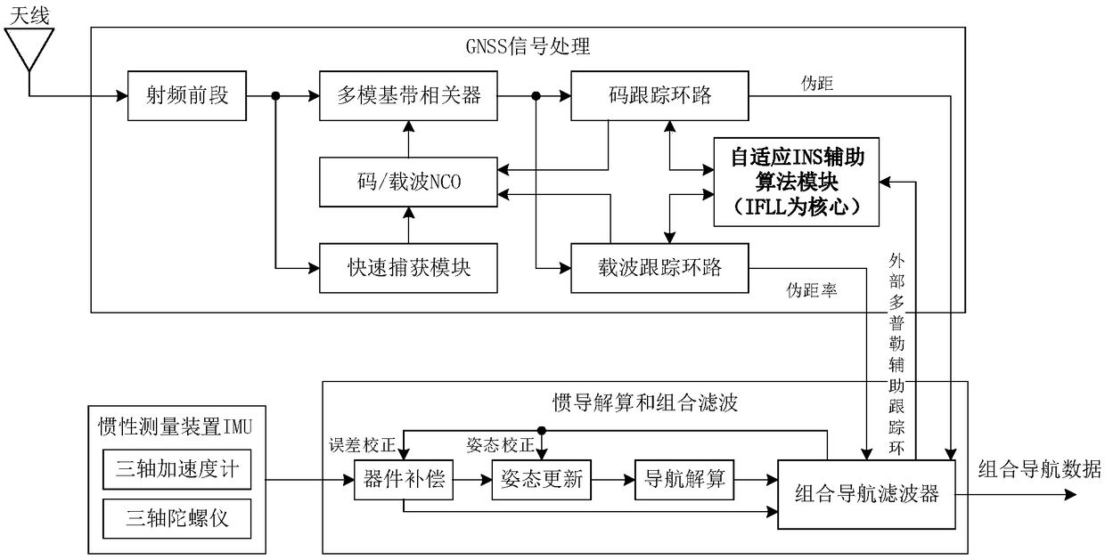
[0028] The present invention can be based on figure 1 The shown device implements, figure 1 It is a navigation device based on INS adaptive auxiliary tracking loop based on EKF filtering, and the device is based on INS auxiliary FLL technology. The navigation device includes: a satellite signal receiving antenna, a GNSS signal processing unit, an inertial measurement device, an inertial navigation solution and a combined processing unit; the GNSS signal processing unit includes: a radio frequency front end, a multi-mode baseband correlator, a code / carrier NCO control module, Fast acquisition module, code tracking loop, carrier tracking loop, adaptive INS auxiliary algorithm module; inertial measurement device includes: three-axis accelerometer, three-axis gyroscope; inertial navigation solution and tight combination processing unit include: device compens...


PUM


Abstract

The invention discloses a navigation method of an INS-assisted GNSS scalar tracking ring; the method adopts a parallel capturing algorithm and an EKF-filtering-based INS self-adaptive auxiliary scalartracking loop method, so that the tracking sensitivity of satellite signals in severe electromagnetic environment is improved, and therefore the anti-interference capability of a satellite navigationreceiver is improved; and the method is an effective way for improving the combined navigation capability without increasing the hardware cost of the combined navigation.

Description

technical field [0001] The invention belongs to the technical field of satellite positioning and navigation, and in particular relates to a navigation method for an INS-aided GNSS scalar tracking loop. Background technique [0002] The global satellite navigation system can provide location, speed and time information in real time around the clock, and has become an indispensable source of navigation information for low-cost guided weapons. High dynamic positioning and navigation systems are widely used in guided weapons. However, due to the low power of satellite signals, the satellite navigation system faces a harsh electromagnetic environment with weak signals and strong interference, and is vulnerable to unintentional and intentional interference. Low-cost guided rockets, guided artillery shells and other guided munitions are limited by cost and volume, and it is difficult to use high-performance and high-cost antenna arrays combined with space-time adaptive filtering a...

Claims


Application Information

Patent Timeline
IPC IPC(8): G01S19/47G01S19/24G01S19/29G01S19/30
CPCG01S19/24G01S19/29G01S19/30G01S19/47
Inventor 李传军李兴城孙巍
Owner BEIJING INSTITUTE OF TECHNOLOGYGY
Why Eureka
Try Eureka