Navigation method based on INS-assisted (Inertial Navigation System) GNSS (Global Navigation Satellite System) vector tracking loop

A technology of vector tracking loop and navigation method, which is applied in the field of navigation based on INS-assisted GNSS vector tracking loop, which can solve the problems of being vulnerable to unintentional and intentional interference, weak signal and strong interference, and difficulty in adopting high-performance and high-cost anti-jamming technology, etc. problem, to achieve the effect of improving integrated navigation ability and improving navigation ability

Pending Publication Date: 2019-02-05
BEIJING INSTITUTE OF TECHNOLOGYGY
View PDF4 Cites 11 Cited by
  • Summary
  • Abstract
  • Description
  • Claims
  • Application Information

AI Technical Summary

Problems solved by technology

However, due to the low power of satellite signals, the satellite navigation system faces a harsh electromagnetic environment with weak signals and strong interference, and is vulnerable to unintentional and intentional interference.
Low-cost guided rockets, guided artillery shells and other guided munitions are limited by cost and volume, and it is difficult to use high-performance and high-cost antenna arrays combined with space-time adaptive filtering and other anti-jamming technologies

Method used


Image

  • Navigation method based on INS-assisted (Inertial Navigation System) GNSS (Global Navigation Satellite System) vector tracking loop
  • Navigation method based on INS-assisted (Inertial Navigation System) GNSS (Global Navigation Satellite System) vector tracking loop
  • Navigation method based on INS-assisted (Inertial Navigation System) GNSS (Global Navigation Satellite System) vector tracking loop

Examples


Embodiment Construction

[0021] The present invention will be described in detail below with reference to the accompanying drawings and examples.

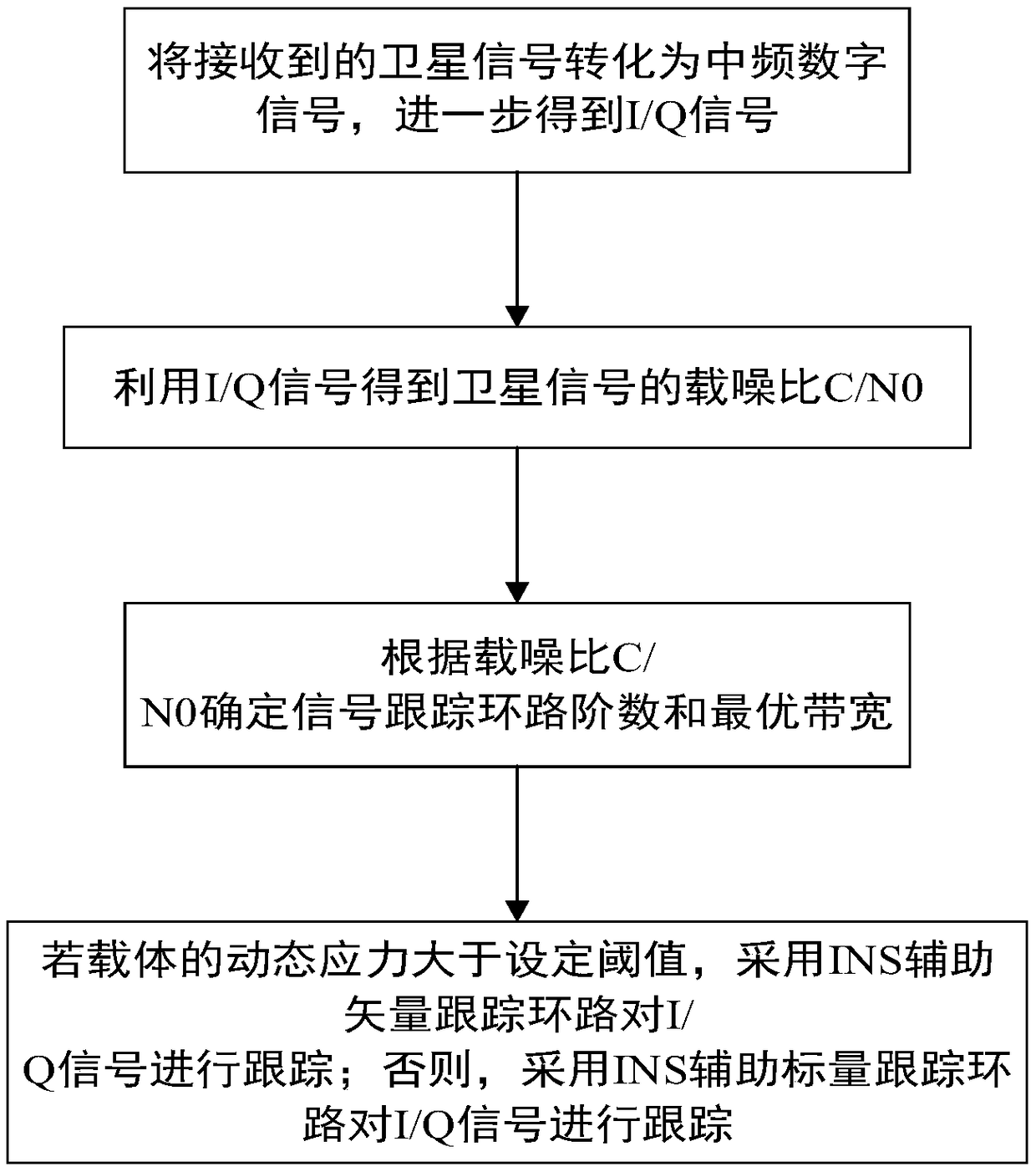
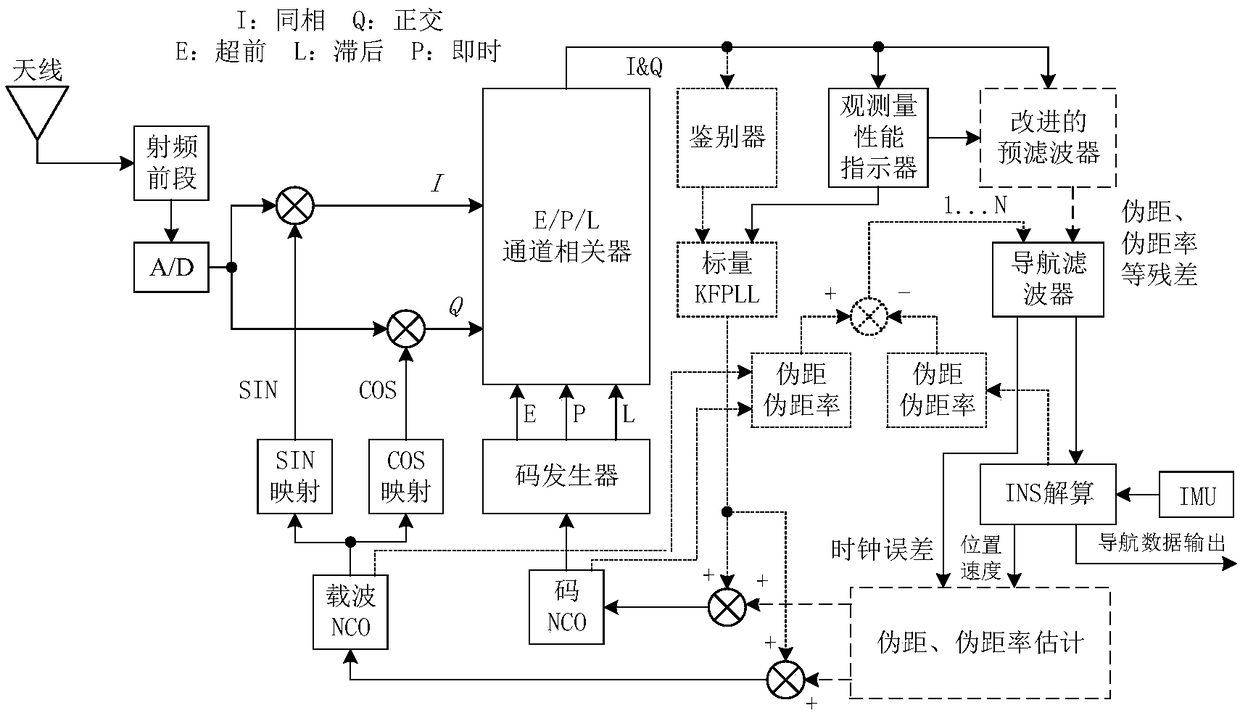
[0022] The present invention improves the tracking sensitivity, receiver anti-interference ability and navigation and positioning ability in harsh electromagnetic environments by adopting the ultra-tight coupling technology based on the INS-assisted GNSS vector tracking loop, and improves the integrated navigation capability without increasing the hardware cost of the integrated navigation effective solution.

[0023] In order to improve the receiver's ability to track the dynamic performance in a high dynamic environment, it is necessary to increase the loop bandwidth, but increasing the loop bandwidth will increase the loop noise and reduce the loop tracking performance. INS assistance can solve the needs of dynamic performance and noise suppression in high dynamic environments. The Doppler information in the INS forecast satellite and receiving antenna ...


PUM


Abstract

The invention discloses a navigation method based on an INS-assisted (Inertial Navigation System) GNSS (Global Navigation Satellite System) vector tracking loop. The navigation method comprises the following steps: S1: converting a received satellite signal into an intermediate frequency digital signal, and carrying out carrier wave removal and integral clearing on the intermediate frequency digital signal to obtain an I/Q signal; S2: utilizing the I/Q signal to obtain a carrier-to-noise ratio C/N0 of the satellite signal; S3: determining a signal tracking loop order and an optimal bandwidth according to the carrier to noise ratio C/N0; and S4: if the dynamic stress of the carrier is greater than a set threshold value, adopting the INS-assisted vector tracking loop to track the I/Q signal,and otherwise, adopting an INS-assisted scalar tracking loop to track the I/Q signal. By use of the method, the navigation ability of a highly dynamic receiver under a high-adverse electromagnetic environment can be improved, and the method is especially suitable for navigation requirements of missile-borne high-dynamic satellite navigation under a complex electromagnetic environment.

Description

technical field [0001] The invention belongs to the technical field of satellite positioning and navigation, and in particular relates to a navigation method based on an INS-aided GNSS vector tracking loop. Background technique [0002] The global satellite navigation system can provide position, speed and time information in real time around the clock, and has become an indispensable source of navigation information for low-cost guided weapons. High dynamic positioning and navigation systems are widely used in guided weapons. However, due to the low power of satellite signals, the satellite navigation system faces a harsh electromagnetic environment with weak signals and strong interference, and is vulnerable to unintentional and intentional interference. Low-cost guided rockets, guided artillery shells and other guided munitions are limited by cost and volume, and it is difficult to use high-performance and high-cost antenna arrays combined with space-time adaptive filteri...

Claims


Application Information

Patent Timeline
Patent Type & Authority Applications(China)
IPC IPC(8): G01S19/47G01S19/24G01S19/29G01S19/30
CPCG01S19/24G01S19/29G01S19/30G01S19/47
Inventor 李传军李兴城孙巍
Owner BEIJING INSTITUTE OF TECHNOLOGYGY
Why Eureka
Try Eureka