A method for managing spatial data versions

A technology of spatial data and management methods, which is applied in the direction of data error detection and response error generation in electrical digital data processing and calculation, can solve problems such as insufficient version management and no good support, and achieve Realize the effects of merging and conflict handling, improving efficiency, and managing flexibly

Inactive Publication Date: 2019-02-05
CHINA PETROLEUM & CHEM CORP +1
View PDF5 Cites 3 Cited by
  • Summary
  • Abstract
  • Description
  • Claims
  • Application Information

AI Technical Summary

Problems solved by technology

[0004] For the existing spatial data storage, the version management is not sufficient. There is no good support for multiple imports of spatial data to generate multiple versions, but they are managed separately as different spatial data layers; in addition For the addition, modification and deletion of spatial data primitives, it is also necessary to save and backup as a separate incremental version, so that it can be restored at any time
[0005] When choosing version recovery, you should be able to choose a suitable recovery method according to the version type, such as replacing all records for the main version, and using incremental recovery for the version modified by the user record level. The existing geographic information system is not very good. nice to achieve this

Method used


Image

  • A method for managing spatial data versions
  • A method for managing spatial data versions
  • A method for managing spatial data versions

Examples


Embodiment Construction

[0054] The implementation of the present invention will be described in detail below in conjunction with the accompanying drawings and examples, so as to fully understand and implement the process of how to apply technical means to solve technical problems and achieve technical effects in the present invention. It should be noted that, as long as there is no conflict, each embodiment and each feature of each embodiment in the present invention can be combined with each other, and the formed technical solutions are all within the protection scope of the present invention.

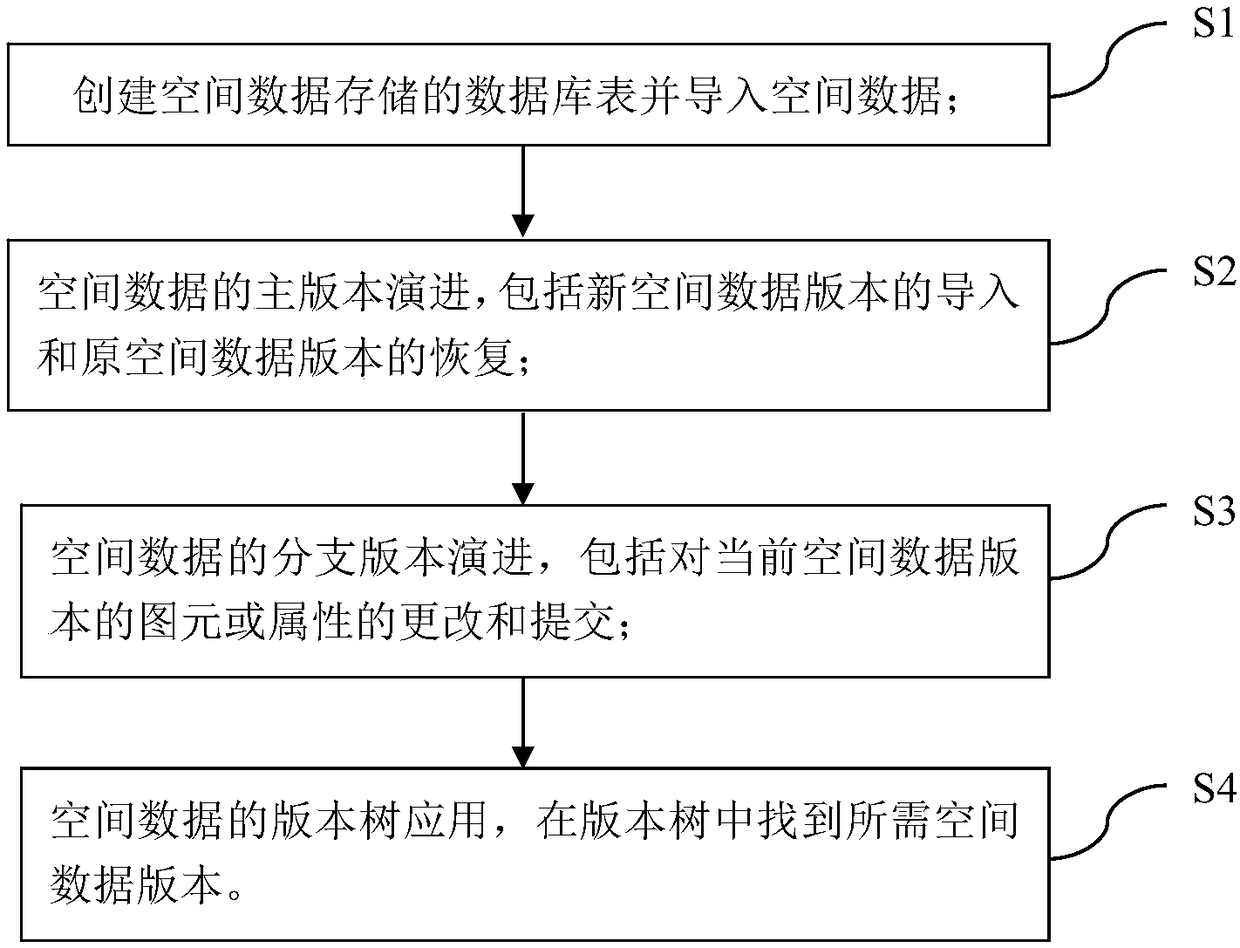
[0055] Such as figure 1 As shown, the present invention discloses a flow chart of a method for managing spatial data versions, including the following steps:

[0056] S1. Create a database table for spatial data storage and import spatial data;

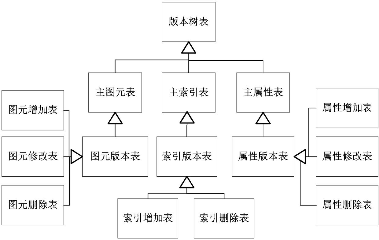
[0057] S2. The evolution of the main version of spatial data, including the import of the new version of spatial data and the recovery of the original version of s...


PUM


Abstract

The invention provides a management method of spatial data version, comprising the following steps: S1, creating a database table of spatial data storage and importing the spatial data; S2, the evolution of the main version of the spatial data, including the import of the new version of the spatial data and the restoration of the original version of the spatial data; S3, branch version evolution of spatial data, including modification and submission of graphic elements or attributes of the current version of the spatial data; S4, the version tree application of the spatial data, and finding the required version spatial data in the version tree. The invention realizes merging and conflict processing of spatial data editing operation. The record-level version incremental backup and recoveryis realized, which improves the efficiency, and the spatial data version is advanced, traced back and fused, which makes the spatial data version management more flexible.

Description

technical field [0001] The invention relates to the technical field of computer software development, in particular to a method for managing spatial data versions. Background technique [0002] The development and application of geographic information systems has led to the continuous growth of spatial data, and the storage and management of massive spatial data has become very important, which is also the bottleneck of the development of geographic information systems. How to design a good spatial data version management model, support multi-version recovery, storage and backup of spatial data change operations, and provide more flexible spatial data editing functions have become problems that need to be solved in geographic information systems. [0003] The storage structure of spatial data has experienced five eras: file system storage, hybrid data storage, relational database storage, object-oriented database storage, and object-relational storage. At present, in terms ...

Claims


Application Information

Patent Timeline
Patent Type & Authority Applications(China)
IPC IPC(8): G06F11/14
CPCG06F11/1458
Inventor 彭成盛秀杰
Owner CHINA PETROLEUM & CHEM CORP
Why Eureka
Try Eureka