
Route planning safety assessment method for unmanned aerial vehicle

A technology for route planning and drones, applied in navigation computing tools, etc., can solve problems such as excessive redundancy, waste of resource costs, and increased range of drones

Active Publication Date: 2019-02-15
BEIJING INST OF ASTRONAUTICAL SYST ENG +1
View PDF6 Cites 6 Cited by
  • Summary
  • Abstract
  • Description
  • Claims
  • Application Information

AI Technical Summary

Problems solved by technology

With the increase of the range of drones, it is necessary to carry out route planning for drones. In the route planning of drones, it is necessary to avoid entering the air above no-fly zones such as important meeting areas and important buildings. At this stage, drone flight is mainly considered. Stay away from the no-fly zone directly. Although this method can ensure that the drone is far away from the no-fly zone, and the planning is simple, it increases the range of the drone, wastes resource costs, and has too much redundancy.

Method used


Image

  • Route planning safety assessment method for unmanned aerial vehicle
  • Route planning safety assessment method for unmanned aerial vehicle
  • Route planning safety assessment method for unmanned aerial vehicle

Examples


Embodiment Construction

[0087] 1) No-fly zone OBB bounding box (Oriented Bounding Box, direction bounding box) structure

[0088] (1) No-fly zone bounding box modeling

[0089] The shape of the no-fly zone is figure 1 As shown, the boundary points of the region are represented by latitude and longitude heights, so it is necessary to convert 2n boundary points to the geocentric coordinate system through coordinate transformation, and the boundary points on the bottom surface ( figure 1 Middle black circle) is converted by the following formula:

[0090]

[0091] Boundary points on the top surface ( figure 1 Middle black triangle) is converted by the following formula:

[0092]

[0093] Among them, B i is the geocentric latitude of the i-th point on the bottom of the no-fly zone, L i is the longitude of the i-th point on the bottom of the no-fly zone, R is the radius of the earth, and h is the elevation of the no-fly zone.

[0094] The coordinate mean of the above 2n coordinate points is as...


PUM


Abstract

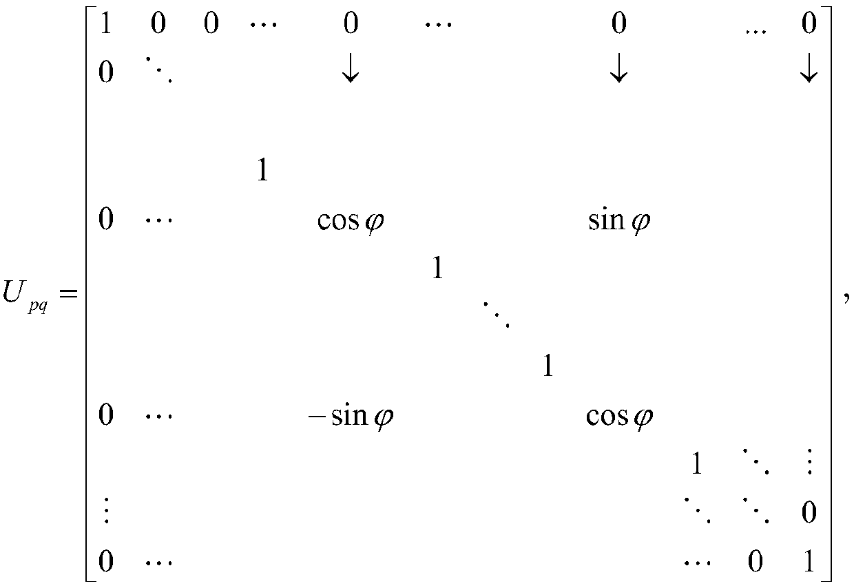
The invention discloses a route planning safety assessment method for an unmanned aerial vehicle. The method comprises the following steps: (1) calculating the central point coordinates and principledirection semi-diameter of a bounding box according to an OBB bounding box construction algorithm; (2) calculating the covariance matrix eigenvalue and eigenvector of the OBB bounding box by using a Jacobi iterative algorithm; (3) constructing a no-fly zone and an unmanned aerial vehicle bounding box respectively, carrying out safety assessment on the route of the unmanned aerial vehicle by usinga collision detection algorithm of the bounding box, if the route of the unmanned aerial vehicle goes through the no-fly zone, the route does not meet the safety requirement. According to the method,by using the collision detection principle of the bounding box, whether the route of the unmanned aerial vehicle goes through the no-fly zone can be judged accurately, the method is safe and reliable,the resources are not wasted, and a solution is provided for the route planning safety analysis for the unmanned aerial vehicle.

Description

technical field [0001] The invention relates to a safety evaluation method for unmanned aerial vehicle route planning, belonging to the field of unmanned aerial vehicle route planning. Background technique [0002] With the development of science and technology and the improvement of people's living standards, UAVs have gradually entered people's lives. UAVs are widely used in short-distance and short-distance aerial photography, photogrammetry, remote sensing data collection, agricultural plant protection, and land surveying and mapping. Application, with the increase of the drone's battery life, it has gradually developed into a medium and large drone, and its application is also more extensive, involving power inspection, environmental monitoring, express transportation, etc. With the increase of the range of drones, it is necessary to carry out route planning for drones. In the route planning of drones, it is necessary to avoid entering the air above no-fly zones such as...

Claims


Application Information

Patent Timeline
IPC IPC(8): G01C21/20
CPCG01C21/20
Inventor 张蓉何信华刘朝阳崔鑫胡钰连彦泽钱航韩亮邱士亮颜廷贵李世鹏徐华丽赵雷马利白健虞洋段飞鹏亓俊卿陈绍露杨志方王琳胡昭昀杨馨路长刚蔡建波姜先炜冀航刘莞尔
Owner BEIJING INST OF ASTRONAUTICAL SYST ENG
Learn More