Display system and marking method for geological digital map

An electronic map and display system technology, applied to measuring devices, instruments, scientific instruments, etc., can solve problems such as the inability to collect test data remotely, and the lack of intelligence of the drilling machine, so as to reduce manual intervention, realize data automation, and have a novel structure Effect

Pending Publication Date: 2019-02-15
ZHEJIANG HAITIAN CONSTR GROUP
View PDF0 Cites 1 Cited by
  • Summary
  • Abstract
  • Description
  • Claims
  • Application Information

AI Technical Summary

Problems solved by technology

[0003] The purpose of the present invention is to provide a geological electronic map display system and a geological electronic map marking method to solve the problem that the existing drilling machines are not intelligent and cannot collect and detect data remotely

Method used


Image

  • Display system and marking method for geological digital map
  • Display system and marking method for geological digital map
  • Display system and marking method for geological digital map

Examples


Embodiment Construction

[0031] In order to make the purpose, technical solutions and advantages of the embodiments of the present invention clearer, the technical solutions in the embodiments of the present invention will be clearly and completely described below in conjunction with the drawings in the embodiments of the present invention. Obviously, the described embodiments It is a part of embodiments of the present invention, but not all embodiments. The components of the embodiments of the invention generally described and illustrated in the figures herein may be arranged and designed in a variety of different configurations. Accordingly, the following detailed description of the embodiments of the invention provided in the accompanying drawings is not intended to limit the scope of the claimed invention, but merely represents selected embodiments of the invention. Based on the embodiments of the present invention, all other embodiments obtained by persons of ordinary skill in the art without cre...


PUM


Abstract

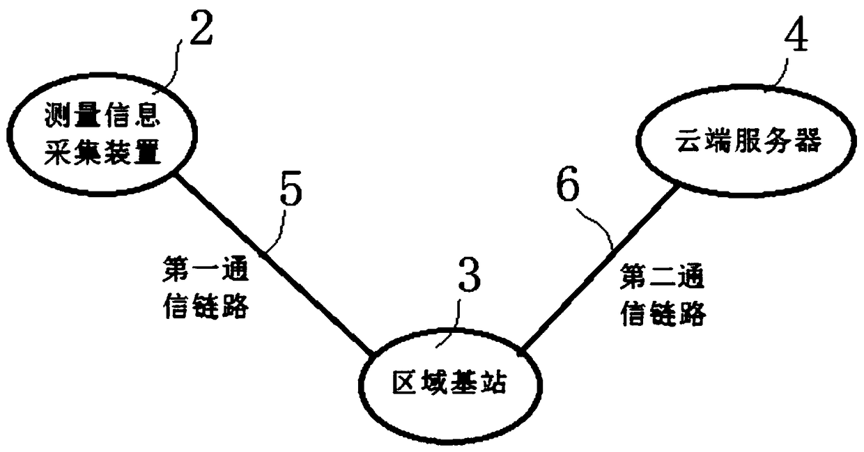
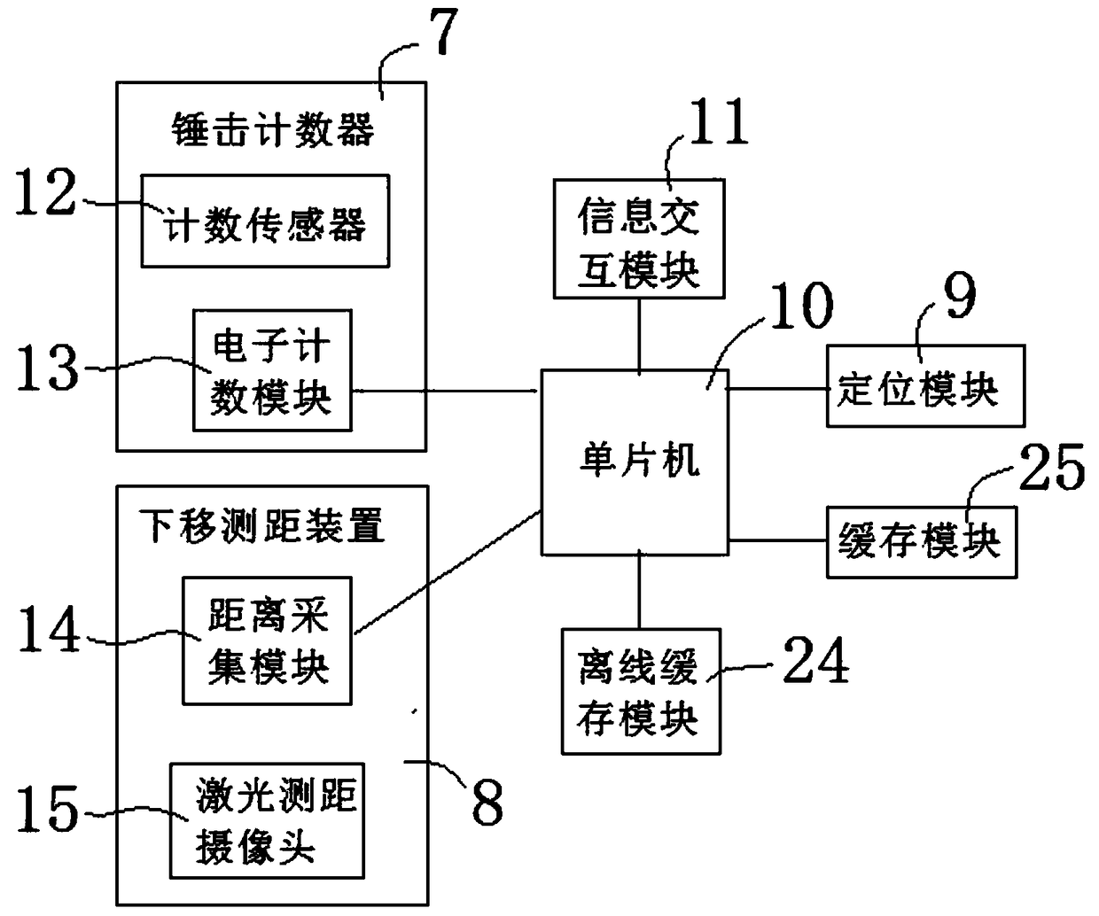
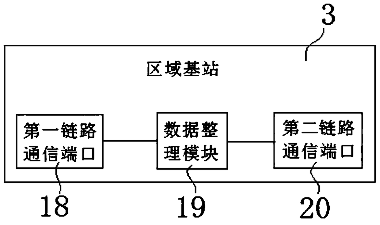
The invention discloses a display system and a marking method for a geological digital map. The display system comprises a drilling device, a measurement information acquisition device, a regional base station, a cloud server, and interaction information of a first communication link and a second communication link. The marking method comprises the steps of: the measurement information acquisitiondevice automatically recording the hammering number of the drilling device and the downward moving distance of a drilling rod, and wirelessly transmitting the acquired measurement information and acquired positioning information to the regional base station; the regional base station receiving the acquired measurement information, calculating to obtain soil bearing capacity information accordingto the measurement information, and uploading the soil bearing capacity information to the cloud server; and the cloud server receiving the acquired positioning information, matching with a corresponding position on the digital map according to the acquired positioning information, and setting a display mark. According to the display system and the marking method for the geological digital map, the measurement data is acquired remotely and automatically through a wireless transmission technology; the intelligent degree is high, and the manual intervention is reduced to the maximum limit, so that the interference of personnel to the measurement data is avoided, and the working efficiency and the data accuracy are improved.

Description

technical field [0001] The invention relates to the technical field of drilling machine detection, in particular to a geological electronic map display system and a geological electronic map marking method. Background technique [0002] The drilling machine is used for the geology of buildings, highways, and water conservancy geological systems, and the detection of foundation density. In the process of on-site use, manual counting is used, that is, the number of 10 kg plumb hammers is observed and recorded by human eyes. Counting personnel must observe the number of plumb hammer strikes and the falling depth of the drill rod throughout the process. Due to the large number of times and high frequency, it is easy to make mistakes and omissions, resulting in the need for re-drilling, which is time-consuming and labor-intensive, and it is difficult to guarantee the quality of work. Contents of the invention [0003] The purpose of the present invention is to provide a geologi...

Claims


Application Information

Patent Timeline
IPC IPC(8): G01N3/34
CPCG01N3/34G01N2203/0682G01N2203/0641G01N2203/0039G01N2203/0005
Inventor 娄鹏石伟太姚健田炎良
Owner ZHEJIANG HAITIAN CONSTR GROUP
Why Eureka
Try Eureka