A method of building remote sensing image recognition based on convolution neural network

A convolutional neural network and remote sensing image technology, which is applied in the field of remote sensing image supervision and classification, can solve the problems of not achieving automation, affecting the accuracy of building outlines, and the accuracy of segmentation results is not very good.

Inactive Publication Date: 2019-02-26
SOUTH CHINA AGRI UNIV
View PDF7 Cites 55 Cited by
  • Summary
  • Abstract
  • Description
  • Claims
  • Application Information

AI Technical Summary

Problems solved by technology

[0005] 1. Disadvantages of research on building information extraction methods in oilfield areas based on high-resolution remote sensing image data: using uniform structural elements for morphological operations will result in under-optimization or over-optimization, which affects the accuracy of building outlines; reasons: When optimizing the morphology of the extracted buildings, in some satellite remote sensing images with large spatial scales, the size of different buildings varies greatly
[0006] 2. Object-oriented high-resolution remote sensing image building contour extraction research Disadvantages: no automation; reason: the implementation of the method is based on existing software
[0007] 3. Disadvantages of the underwater optical intelligent perception method based on the red channel and the full convolutional neural network: the network model is too single, although the last upsampling layer is enlarged by 32 times, and the output feature map is used to restore the details of the convolutional layer, but the obtained The resolution of the image is still very low; the reason: an upsampling layer is enlarged by 32 times, only a small part of the details in the pooling process are restored, and the resulting feature map is very rough
[0008] 4. Disadvantages of the research on building extraction technology based on high-resolution visible light remote sensing images: the relationship between pixels in the method is not considered enough
The classification of the target in the network model and the determination of the pixel position of the image are not fully considered, resulting in poor accuracy of the segmentation results; the reason: the classification of the target in the network model of the image and the determination of the pixel position are two mutual constraints The problem, these two problems will affect the segmentation results

Method used


Image

  • A method of building remote sensing image recognition based on convolution neural network
  • A method of building remote sensing image recognition based on convolution neural network
  • A method of building remote sensing image recognition based on convolution neural network

Examples


Embodiment

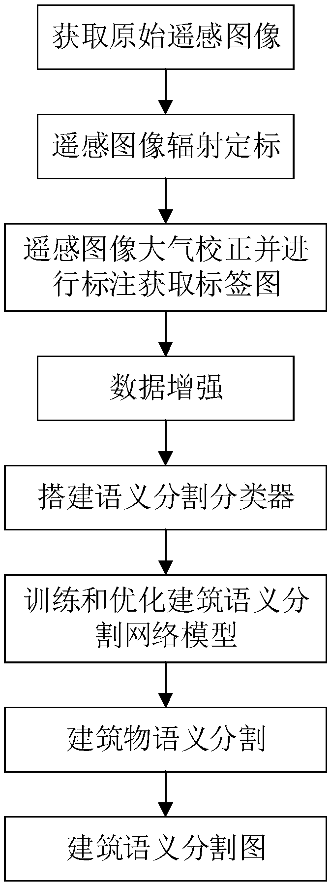
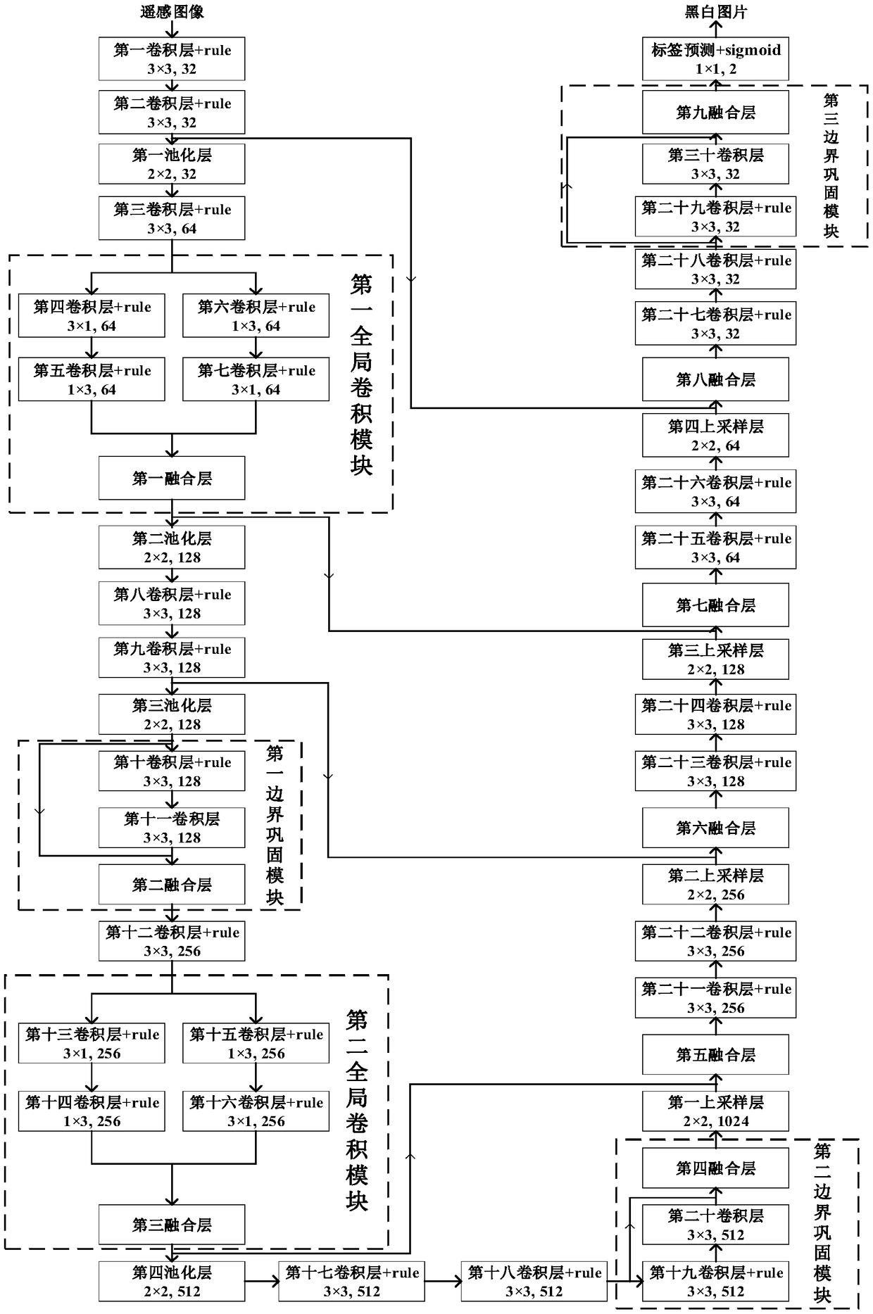
[0054] A method for building remote sensing image recognition based on convolutional neural network, such as figure 1 shown, including the following steps:

[0055] Step 1: Obtain the original remote sensing image; the original remote sensing image is downloaded from the remote sensing image data website or captured by the drone, choose one of the two;

[0056] The second step: radiometrically calibrate the original remote sensing image to obtain the radiometrically calibrated remote sensing image; the radiometric calibration, the specific process is: use the radiometric calibration tool to obtain the parameters in the original remote sensing image setting panel, and complete the radiometric calibration mark;

[0057] Step 3: Perform atmospheric correction on the radiometrically calibrated remote sensing image to obtain the atmospherically corrected remote sensing image; label each pixel of the atmospherically corrected remote sensing image to obtain the corresponding label ...


PUM


Abstract

The invention discloses a building remote sensing image identification method based on a convolution neural network, comprising the following steps: acquiring an original remote sensing image; Radiometric calibration of the original remote sensing image; Atmospheric correction is carried out on the radiometric calibrated remote sensing image, and the atmospheric calibrated remote sensing image islabeled. The atmospheric corrected remote sensing image and the label map are randomly segmented and then the data are enhanced to form a data set. A semantic segmentation classifier is built to get the network model of architectural semantic segmentation. The atmospheric corrected remote sensing image is sent to the building semantic segmentation network module for building semantic segmentation,and the building semantic segmentation map is obtained. The technical scheme of the invention improves the accuracy of building and non-building classification of remote sensing images, and solves the problems of object classification and pixel position determination in the building semantic segmentation network model of remote sensing images restrict each other.

Description

technical field [0001] The invention relates to the research field of supervised classification of remote sensing images, in particular to a method for recognizing building remote sensing images based on convolutional neural networks. Background technique [0002] Traditional remote sensing image classification methods mainly include supervised classification and object-oriented image classification. Supervised classification is to use known categories of samples to determine the categories of unknown samples. Commonly used supervised classification includes minimum distance classification, maximum likelihood classification, support vector machine classification, artificial neural network classification, etc. The object-oriented remote sensing image classification method not only relies on the spectral characteristics of ground objects, but also uses its geometric information and structural information. The smallest unit of an image is not a single pixel but an object, and ...

Claims


Application Information

Patent Timeline
Patent Type & Authority Applications(China)
IPC IPC(8): G06K9/00G06K9/62G06N3/04
CPCG06V20/176G06N3/045G06F18/241
Inventor 郭玉彬吴思奥李西明
Owner SOUTH CHINA AGRI UNIV
Why Eureka
Try Eureka