System and method for monitoring building displacement in fire based on Beidou satellites

A Beidou satellite and displacement monitoring technology, applied in the field of measurement systems, can solve problems such as inconvenient installation, easy deformation, and increased costs, and achieve the effect of avoiding safety crises

Pending Publication Date: 2019-03-01
HUAQIAO UNIVERSITY
View PDF0 Cites 4 Cited by
  • Summary
  • Abstract
  • Description
  • Claims
  • Application Information

AI Technical Summary

Problems solved by technology

However, there is no specific implementation plan for how to monitor the displacement of building structures under fire, especially for high-rise buildings, tower cranes and transmission towers. If the traditional monitoring method is used to monitor buildings under fire, There is a risk of the receiver being burned, which increases the cost of monitoring, and in high-rise buildings, the receiver is directly installed at the monitoring point where the high-rise building is easily deformed. Since the GNSS receiver itself is a bit large, it is inconvenient to install and difficult

Method used


Image

  • System and method for monitoring building displacement in fire based on Beidou satellites
  • System and method for monitoring building displacement in fire based on Beidou satellites

Examples


Embodiment Construction

[0022] Specific embodiments of the present invention will be described in detail below in conjunction with the accompanying drawings.

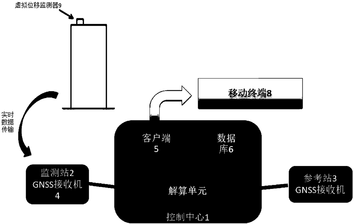
[0023] Such as figure 1 As shown, a high-rise building displacement monitoring system includes a control center 1, a plurality of monitoring stations 2 and a plurality of reference stations 3, and the monitoring stations 2 and the reference stations 3 are all arranged at a stable base point, and the stable base point can be Select a solid bedrock, the monitoring station 2 and the reference station 3 are provided with a GNSS receiver 4, the GNSS receiver 4 is connected to the control center 1 through the network, and the control center 1 includes a client 5, a database 6 and a calculation unit 7, the The client 5 is used for data analysis, icon display and alarm, the calculation unit 7 is used to receive the data transmitted by the GNSS receiver 4 and perform data conversion, and the database 6 is used to store the data calculated by the calcul...


PUM


Abstract

The invention provides a system and method for monitoring building displacement in fire based on Beidou satellites. The system comprises a control center, a plurality of monitoring stations and a plurality of reference stations. The monitoring stations and the reference stations are disposed at stable base points, and the monitoring stations and the reference stations are each provided with a GNSSreceiver, and the GNSS receivers are connected with the control center through a network. The control center includes a client, a database, and a resolving unit, wherein the client is used for data analysis, icon display, and alarm, the resolving unit is used for receiving the data transmitted by the GNSS receivers and performing data conversion, and the database is used for storing the data solved by the solving unit as a data source for the client 5 for data analysis. A virtual displacement monitor is installed on a monitored building, and transmits the data to the GNSS receivers of the monitoring stations in real time, and the Beidou satellites simultaneously receive signals from the GNSS receivers of the monitoring stations and the reference stations.

Description

technical field [0001] The invention belongs to the field of measurement systems, in particular to a measurement system for deformation or tilt angle. Background technique [0002] The Beidou satellite navigation system is my country's first-generation regional satellite navigation system and the third satellite navigation system in the world. It can provide positioning, navigation, timing and simple communication services for the entire territory of China and some neighboring countries. And at present, the system has been successfully applied in many fields such as surveying and mapping, telecommunications, water conservancy, fishery, transportation, forest fire prevention, disaster reduction and relief, and public safety, and has produced significant economic and social benefits. In disaster prevention and mitigation, the displacement monitoring of buildings by Beidou satellite navigation system is one of the typical applications of Beidou satellite navigation system in hi...

Claims


Application Information

Patent Timeline
Patent Type & Authority Applications(China)
IPC IPC(8): G01B7/24G01S19/42
CPCG01B7/24G01S19/42
Inventor 董毓利谢戈张大山李胜赋
Owner HUAQIAO UNIVERSITY
Why Eureka
Try Eureka