Method and system for detecting flood depth of substation
A detection method and substation technology, applied in the theoretical field, can solve problems such as low inversion accuracy
- Summary
- Abstract
- Description
- Claims
- Application Information
AI Technical Summary
Problems solved by technology
Method used
Image
Examples
Embodiment 1
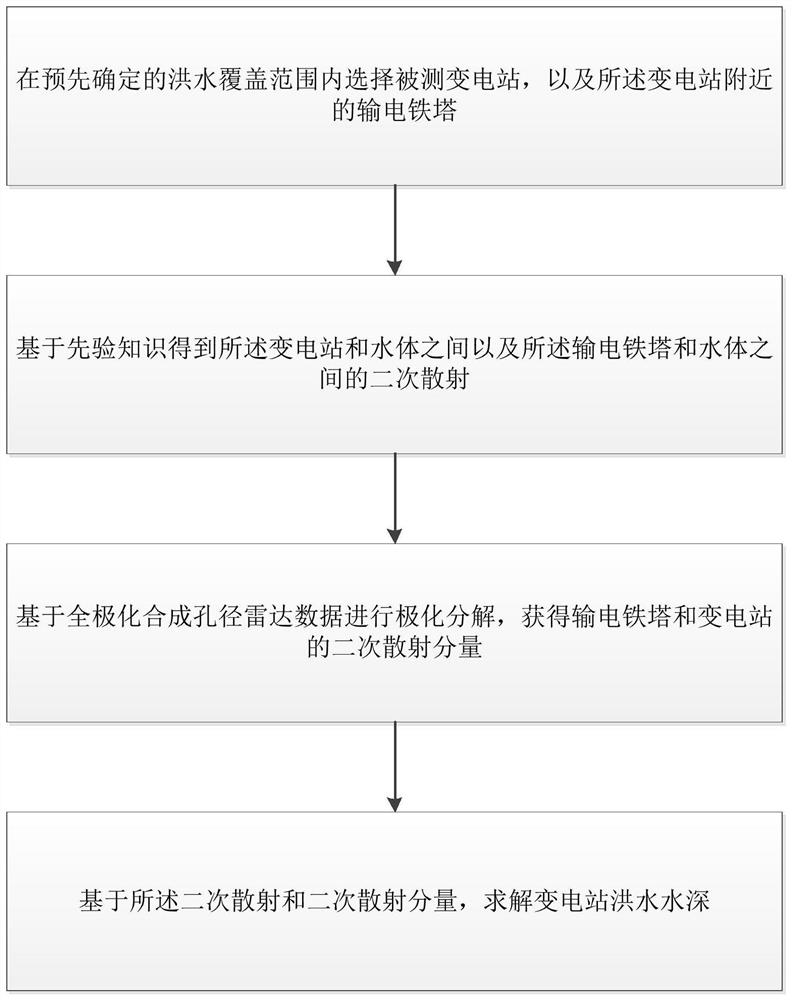
[0058] like figure 1 Shown is a substation flood depth detection method of the present invention, comprising the following steps:
[0059] Step 1: Select the substation to be tested and the transmission tower near the substation within the predetermined flood coverage;
[0060] Step 2: Obtain secondary scattering between the substation and the water body and between the transmission tower and the water body based on prior knowledge;
[0061] Step 3: Perform polarization decomposition based on full-polarization synthetic aperture radar data to obtain secondary scattering components of transmission towers and substations;
[0062]Step 4: Based on the secondary scattering and secondary scattering components, solve the flood depth of the substation.
[0063] Below in conjunction with specific embodiment, the inventive step of the present invention is further explained:
[0064] Explanation for the determination of the flood range in step 1:
[0065] Flood Coverage Monitoring T...
Embodiment 2
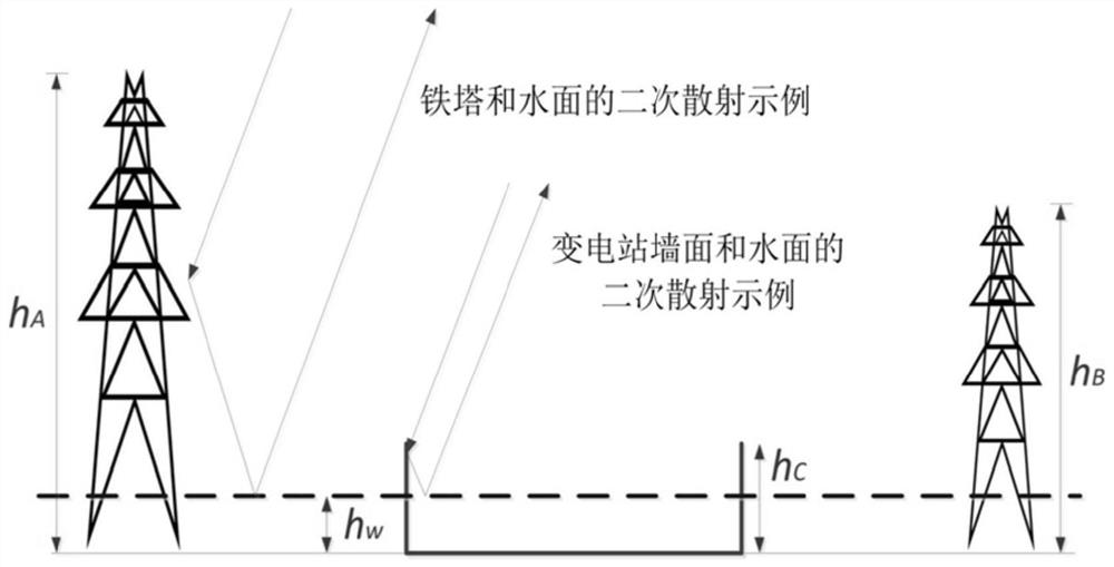
[0104] The first transmission tower height h A , the height of the second transmission tower h B , substation wall height h C , substation perimeter l, transmission tower material and complex dielectric constant ξ T , Substation wall material and complex permittivity ξ B , the wavenumber k of the SAR image, the azimuth angle of the first transmission tower Azimuth of the second transmission tower Azimuth of the substation Incidence angle θ of the first transmission tower A , the second transmission tower incident angle θ B , substation incident angle θ C , the complex dielectric constant ξw of the flood water surface, the standard root height s of the water surface and the standard length L of the water surface.
[0105] like figure 2 It is shown that in the method of this patent, it is necessary to select the substation and two nearby transmission towers with different heights as the basic elements of the equation construction. h A , h B and h C are the heigh...
Embodiment 3
[0114] The invention also relates to a substation flood water depth detection system, comprising:
[0115]Selecting the tested target module: used to select the tested substation and the transmission tower near the substation within the predetermined flood coverage;
[0116] Obtaining secondary scattering module: used to obtain secondary scattering between the substation and the water body and between the transmission tower and the water body based on prior knowledge;
[0117] Obtaining secondary scattering component module: used for polarization decomposition based on full-polarization synthetic aperture radar data to obtain secondary scattering components of transmission towers and substations;
[0118] Solve flood depth module: used to solve the substation flood depth based on the secondary scattering and secondary scattering components.
[0119] The module for selecting the measured target includes a first water body range determination unit, a second water body range det...
PUM
 Abstract
Description
Claims
Application Information
 - R&D
- Intellectual Property
- Life Sciences
- Materials
- Tech Scout
- Unparalleled Data Quality
- Higher Quality Content
- 60% Fewer Hallucinations
Browse by: Latest US Patents, China's latest patents, Technical Efficacy Thesaurus, Application Domain, Technology Topic, Popular Technical Reports.
© 2025 PatSnap. All rights reserved.Legal|Privacy policy|Modern Slavery Act Transparency Statement|Sitemap|About US| Contact US: help@patsnap.com


