A spacecraft based on the genetic reconstruction image relative navigation method

A technology for relative navigation and image reconstruction, applied in the field of spacecraft navigation, it can solve problems such as incomplete target images, and achieve the effects of fewer particles, high navigation accuracy, and reduced power consumption requirements.

Active Publication Date: 2022-08-05
SHANGHAI AEROSPACE CONTROL TECH INST
View PDF9 Cites 0 Cited by
  • Summary
  • Abstract
  • Description
  • Claims
  • Application Information

AI Technical Summary

Problems solved by technology

[0007] Further, in view of the incomplete target image obtained by the visual camera in the space environment, a generative confrontation method is used to restore the complete image from the partial image for relative navigation;

Method used


Image

  • A spacecraft based on the genetic reconstruction image relative navigation method
  • A spacecraft based on the genetic reconstruction image relative navigation method
  • A spacecraft based on the genetic reconstruction image relative navigation method

Examples


Embodiment Construction

[0024] The present invention will be further elaborated below by describing a preferred specific embodiment in detail with reference to the accompanying drawings.

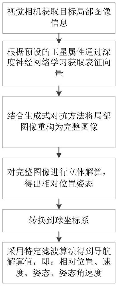
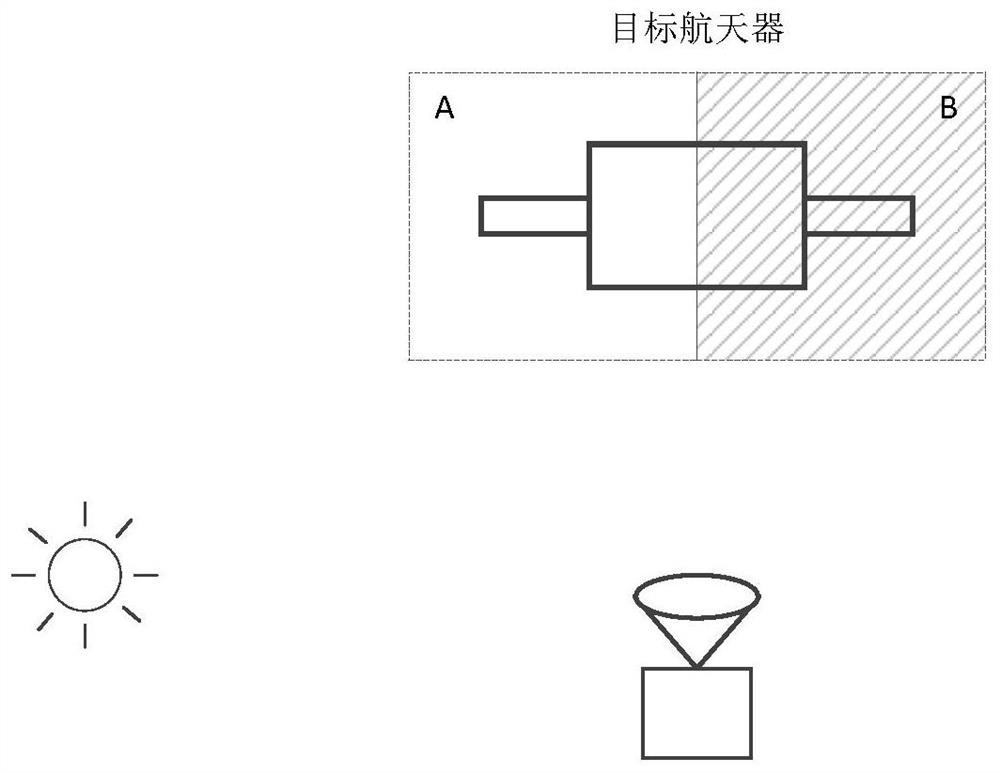
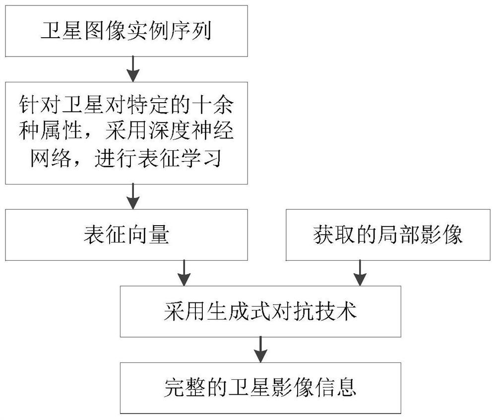
[0025] like figure 1 As shown, a relative navigation method for spacecraft based on generative reconstructed images is characterized in that the target local image information obtained by the visual camera is used as the input quantity, and the representation vector is obtained through deep neural network learning according to the preset satellite attributes, combined with The generative adversarial method reconstructs the partial image obtained by the visual camera into a complete image, performs a three-dimensional solution to the generated complete image, obtains the relative position and attitude, and converts the relative quantity to the spherical coordinate system as the measurement of the navigation system value, the relative motion equation in the spherical coordinate system is used as the navigation state ...


PUM


Abstract

The invention discloses a relative navigation method for a spacecraft based on a generative reconstructed image. Since the sunlight in the space environment where the spacecraft is located is parallel light, the contrast between the illuminated area and the shadow area of ​​the target satellite is strong when it is illuminated by sunlight, resulting in The target image obtained by the vision camera is incomplete. The invention takes the target local image information obtained by the visual camera as the input, obtains the representation vector through deep neural network learning according to the preset satellite attributes, and combines the generative confrontation method to reconstruct the partial image obtained by the visual camera into a complete image, and the generated The complete image is solved in three-dimensional, and the relative position and attitude are obtained, and the relative quantity is converted into the spherical coordinate system as the measurement value of the navigation system, and the relative motion equation in the spherical coordinate system is used as the navigation state equation. The algorithm completes the relative navigation solution. The present invention can complete relative navigation only through passive imaging devices such as visual cameras.

Description

technical field [0001] The invention belongs to the technical field of spacecraft navigation, in particular to relative measurement and navigation technology, and in particular to a relative navigation method for spacecraft based on a generative reconstructed image. technical background [0002] Visual navigation is an important way of relative measurement and navigation between spacecraft. Since the sunlight in the space environment where the spacecraft is located is parallel light, the contrast between the illuminated area and the shadow area of ​​the target satellite is strong when it is illuminated by sunlight. It is easy to produce overexposure; on the contrary, the part that is not illuminated cannot be imaged in the dark. As a result, the target satellite imagery often produces a sharp light-dark demarcation that is only partially visible. How to solve this problem has become one of the research hotspots in the current field. [0003] The existing methods usually a...

Claims


Application Information

Patent Timeline
Patent Type & Authority Patents(China)
IPC IPC(8): G01C21/24G01C21/20
CPCG01C21/20G01C21/24
Inventor 韩飞王兆龙阳光朱文山贺亮梁彦
Owner SHANGHAI AEROSPACE CONTROL TECH INST
Why Eureka
Try Eureka