Real-time evaluation method for submarine topographic survey quality of multi-beam sonar based on amplitude method

A terrain measurement, multi-beam technology, applied in radio wave measurement systems, measurement devices, sound wave re-radiation and other directions, can solve problems such as difficulty in estimation, and achieve the effect of simple and clear judgment criteria, accurate depth estimation, and real-time quality monitoring.

Pending Publication Date: 2019-03-15
HARBIN ENG UNIV
View PDF4 Cites 8 Cited by
  • Summary
  • Abstract
  • Description
  • Claims
  • Application Information

AI Technical Summary

Problems solved by technology

The processing effect of this method is very good, but it also has very obvious limitations. Since it is usually very difficult to estimate the actual signal-to-noise ratio, this method is more suitable for performance prediction analysis or system design, not suitable for Quality monitoring of field data in a routine operating environment

Method used


Image

  • Real-time evaluation method for submarine topographic survey quality of multi-beam sonar based on amplitude method
  • Real-time evaluation method for submarine topographic survey quality of multi-beam sonar based on amplitude method
  • Real-time evaluation method for submarine topographic survey quality of multi-beam sonar based on amplitude method

Examples


Embodiment Construction

[0017] Below in conjunction with accompanying drawing and implementation the present invention will be further introduced:

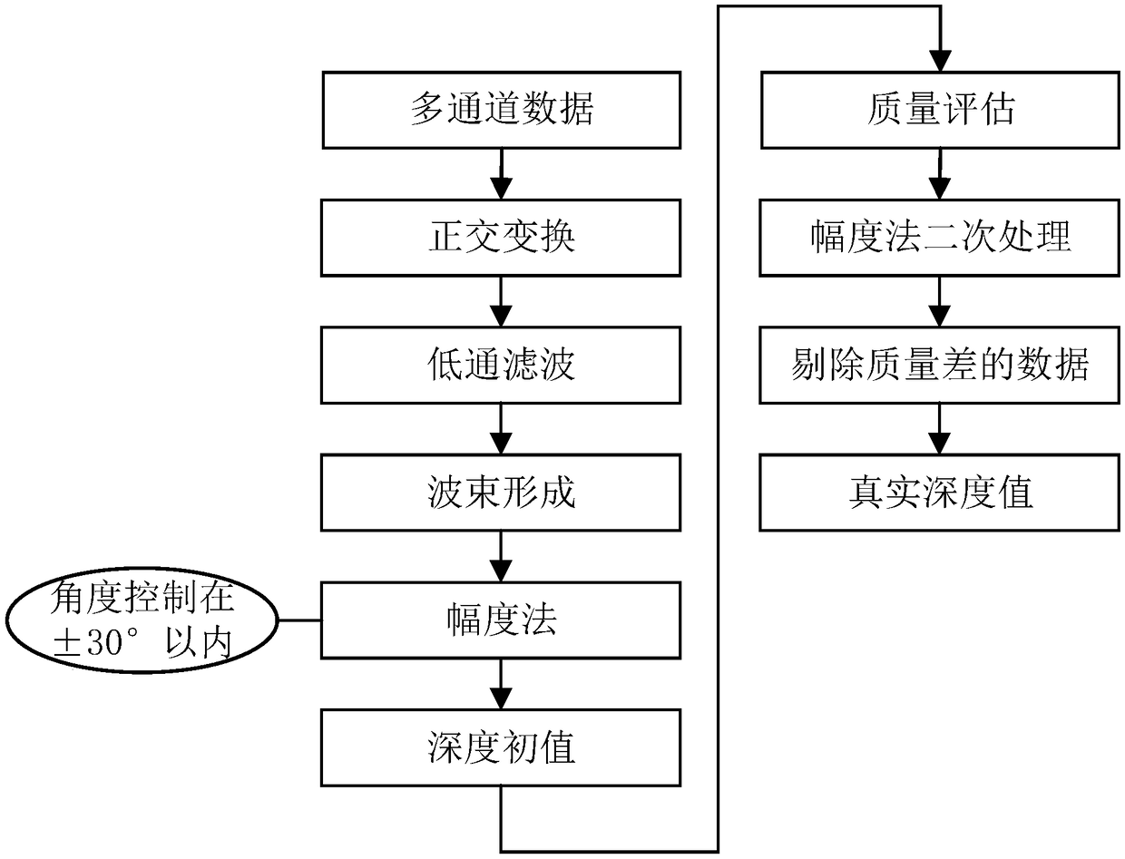
[0018] figure 1 It is a flow chart of multi-beam sonar seabed topographic survey data processing based on the amplitude method, in which the multi-channel data-depth initial value process is the conventional multi-beam sonar amplitude method seabed topographic survey process, and the specific process is as follows: 1. Multi-channel data undergoes orthogonal transformation Finally, a complex signal composed of orthogonal real and imaginary parts is obtained; 2. After the multi-channel data is subjected to orthogonal transformation, the signal is converted into a zero-frequency signal and a multiplied signal in the frequency domain, and the multiplied 3. Perform beamforming processing on the obtained zero-frequency envelope signal to obtain multiple receiving beams distributed perpendicular to the track direction under the preset beam angle, and obtain Th...


PUM


Abstract

The invention relates to a real-time evaluation method for the submarine topographic survey quality of multi-beam sonar based on an amplitude method. The method comprises the steps that based on the statistical characteristics of submarine reverberation, the relative depth sounding error of a multi-beam sonar amplitude method is analyzed by adopting a method of probability statistics, thus an evaluation model of the depth sounding data quality of the amplitude method is established, quality factors of uncertainty of the depth measurement by the quantitative measurement amplitude method are obtained, the method has the characteristic of being independent of any equipment or hydrological conditions, and effective quality evaluation can be carried out on depth data obtained by the multi-beamsonar amplitude method.

Description

technical field [0001] The invention belongs to the field of sonar measurement, in particular to a method for real-time evaluation of the quality of multi-beam sonar seabed topographic measurement based on the amplitude method. Background technique [0002] In the process of multi-beam sonar seabed topographic survey, it is necessary to objectively estimate the error of each calculated depth value. In fact, since the acoustic scattering signal is fluctuating in nature, the estimation of the arrival time or angle is also random, and the fluctuation level is related to the signal-to-noise ratio (SNR) of the received echo signal. In the process of data collection, the error of the detection value in an environment that is too noisy is relatively large, which is not reliable, so the device should have the ability to identify and eliminate these data. And for those parts that have reached the preset threshold and are regarded as reliable detection values, objective indicators re...

Claims


Application Information

Patent Timeline
Patent Type & Authority Applications(China)
IPC IPC(8): G01S15/88G01S7/52
CPCG01S7/52004G01S15/88
Inventor 徐超周天王璐瑶杜伟东陈宝伟
Owner HARBIN ENG UNIV
Why Eureka
Try Eureka